District → Mandi
State → Himachal Pradesh
Kotli is a town and Tehsil in the Mandi district of the Himachal Pradesh. In India, a Tehsil is a subdivision of a district responsible for the administration and revenue collection of a specific area within the district. Tehsils play a crucial role in the local governance structure, contributing significantly to the development and administration of their communities.
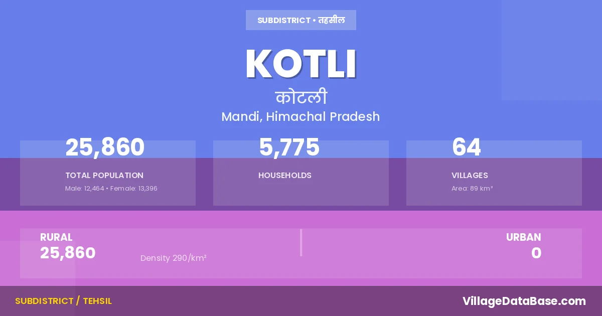
According to the 2011 census The total area of Kotli Tehsil is 89 km², with a population of 25860 people. The population density is 290 inhabitants per square kilometre, and there are approximately 5775 houses in the sub district.
Kotli Tehsil comprises about 64 villages. Below is a list of these villages along with information about their respective gram panchayats and the nearest town:
| # | Village Name | Gram Panchayat | Nearest Town |
|---|---|---|---|
| 1 | Alag | Kot Rew | Mandi |
| 2 | Arnodi | Kotli Rew | Mandi |
| 3 | Arthi | Khalanu Rew | Mandi |
| 4 | Badgaon | Kashan | Mandi |
| 5 | Badyar | Bhargaon Rew | Mandi |
| 6 | Baggi | Baggi Tungal | Mandi |
| 7 | Balahar | Kotli Rew | Mandi |
| 8 | Banog | Lagdhar Rew | Mandi |
| 9 | Barnota | Khalanu Rew | Mandi |
| 10 | Baroha | Kot Rew | Mandi |
| 11 | Batahar | Baggi Tungal | Mandi |
| 12 | Batour | Baggi Tungal | Mandi |
| 13 | Bhargaon | Bhargaon Rew | Mandi |
| 14 | Chaloh | Sai Rew | Mandi |
| 15 | D P F Janitri | Lagdhar Rew | Mandi |
| 16 | D P F Nagan | Baggi Tungal | Mandi |
| 17 | D P F Rachhera | Kotli Rew | Mandi |
| 18 | Darubal | Kot Rew | Mandi |
| 19 | Dawahan | Dawahan | Mandi |
| 20 | Dhalwani | Lagdhar Rew | Mandi |
| 21 | Dhandal | Dhanyara Rew | Mandi |
| 22 | Dhaniara | Dhanyara Rew | Mandi |
| 23 | Dhawali Badehar | Lagdhar Rew | Mandi |
| 24 | Dhawansari | Kot Rew | Mandi |
| 25 | Fagla | Dhanyara Rew | Mandi |
| 26 | Gharaun | Kotli Rew | Mandi |
| 27 | Hart | Kotli Rew | Mandi |
| 28 | Jalaun | Sadoh | Mandi |
| 29 | Jandrola | Tarnoh Rew | Mandi |
| 30 | Kalag | Lagdhar Rew | Mandi |
| 31 | Kalgraum | Sehli Rew | Mandi |
| 32 | Kalothar | Dawahan | Mandi |
| 33 | Kasan | Khalanu Rew | Mandi |
| 34 | Khad Khalyana | Tarnoh Rew | Mandi |
| 35 | Khalwanu | Khalanu Rew | Mandi |
| 36 | Kot | Kot Rew | Mandi |
| 37 | Kotli | Kotli Rew | Mandi |
| 38 | Kun | Kot Rew | Mandi |
| 39 | Kusmul | Dhanyara Rew | Mandi |
| 40 | Kutli | Tarnoh Rew | Mandi |
| 41 | Lagdhar | Lagdhar Rew | Mandi |
| 42 | Laswai Khad | Sadoh | Mandi |
| 43 | Luharad | Bhargaon Rew | Mandi |
| 44 | Mahan | Khalanu Rew | Mandi |
| 45 | Mandokhar | Kot Rew | Mandi |
| 46 | Nalsan | Sai Rew | Mandi |
| 47 | Ropa Matyal | Kot Rew | Mandi |
| 48 | Ropru | Kotli Rew | Mandi |
| 49 | Sadoh | Sadoh | Mandi |
| 50 | Sai | Sai Rew | Mandi |
| 51 | Sain | Uparli Sarwari | Mandi |
| 52 | Samrahan | Dhanyara Rew | Mandi |
| 53 | Saploh | Uparli Sarwari | Mandi |
| 54 | Sarwahan | Nichla Lot Rew | Mandi |
| 55 | Sarwari Buhli | Uparli Sarwari | Mandi |
| 56 | Sarwari Uperli | Uparli Sarwari | Mandi |
| 57 | Satahan | Lagdhar Rew | Mandi |
| 58 | Sathol | Sehli Rew | Mandi |
| 59 | Sehli | Sehli Rew | Mandi |
| 60 | Sikan | Uparli Sarwari | Mandi |
| 61 | Sukhsal | Kotli Rew | Mandi |
| 62 | Tarnoh | Tarnoh Rew | Mandi |
| 63 | Taryasal | Dawahan | Mandi |
| 64 | Thanaut | Sehli Rew | Mandi |
The population is distributed between urban and rural areas as follows:
| Particulars | Rural | Urban | Total |
|---|---|---|---|
| Total Population | 25860 | 0 | 25860 |
| Male Population | 12464 | 0 | 12464 |
| Female Population | 13396 | 0 | 13396 | Population Density | 290 / km² | 290 / km² |
The distribution of households in the Kotli is:
| Rural Households | Urban Households | Total Households |
|---|---|---|
| 5775 | 0 | 5775 |
Q: What is Kotli?
A: Kotli is a town and in the Mandi district of the Himachal Pradesh.
Q: What is the total area of Kotli Tehsil?
A: The total area of Kotli Tehsil is 89 km².
Q: What is the population of Kotli Tehsil according to the 2011 census?
A: According to the 2011 census, the population of Kotli Tehsil is 25860.
Q: What is the population density of Kotli Tehsil?
A: The population density of Kotli Tehsil is 290 inhabitants per square kilometre.
Q: How many houses are there in Kotli Tehsil?
A: There are approximately 5775 houses in Kotli Tehsil.
Q: How many villages are there in Kotli Tehsil?
A: There are about 64 villages in Kotli Tehsil.
Q: Which is the largest village by population in Kotli Tehsil?
A: The largest village by population in Kotli Tehsil is Batour, with 995 people.
Q: Which is the smallest village by population in Kotli Tehsil?
A: The smallest village by population in Kotli Tehsil is D P F Janitri, with 0 people.
Q: Which is the largest village by area in Kotli Tehsil?
A: The largest village by area in Kotli Tehsil is D P F Janitri, with 585 km².
Q: Which is the smallest village by area in Kotli Tehsil?
A: The smallest village by area in Kotli Tehsil is Mandokhar, with 16 km².
Q: What is the population distribution between urban and rural areas in Kotli Tehsil?
A: The population distribution in Kotli Tehsil is entirely rural, with a total rural population of 25860.
Q: What is the male population of Kotli Tehsil?
A: The male population of Kotli Tehsil is 12464.
Q: What is the female population of Kotli Tehsil?
A: The female population of Kotli Tehsil is 13396.
Q: How is the household distribution in Kotli Tehsil?
A: The household distribution in Kotli Tehsil is entirely rural, with a total of 5775 households.
Q: How many villages in Kotli Tehsil have a population of less than 100?
A: There are 4 villages in Kotli Tehsil with a population of less than 100.
Q: How many villages in Kotli Tehsil have a population between 100 and 499?
A: There are 46 villages in Kotli Tehsil with a population between 100 and 499.
Q: How many villages in Kotli Tehsil have a population between 500 and 999?
A: There are 14 villages in Kotli Tehsil with a population between 500 and 999.
| Total Population | Villages in Sub District Of Kotli |
|---|---|
| Less than 100 | 4 |
| 100-499 | 46 |
| 500-999 | 14 |