Welcome Back

Forgot password?
Don't have an account?
🏘️ Menu
Ganderbal District 0.0 / 5 (0)

Rayil Village Detailed Information

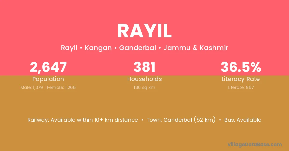
Rayil village is located in the Kangan Tehsil of the Ganderbal district in Jammu & Kashmir .

About Rayil Village

Block / Tehsil → Kangan

District → Ganderbal

State → Jammu & Kashmir

Rayil village has a total population of 2,647 people, of which 1,379 are males and 1,268 are females.

The literacy rate of Rayil village is 36.53%. Male literacy stands at 45.98% and female literacy at 26.26%.

There are approximately 381 households in Rayil village.

Ganderbal (52 km) is the nearest town to Rayil village for major economic activities and is located approximately 52 km away.

Population of Rayil Village

The population of Rayil village is distributed between literate and illiterate residents as follows:

Population distribution of Rayil village by literacy and gender
Particulars Male Female Total
Literate 634 333 967
Illiterate 745 935 1,680
Total 1,379 1,268 2,647

Source: Census 2011

Nearby Villages

List of nearby villages around Rayil village
Village District
Forest Block Anantnag
Forest Block Badgam
Forest Block Badgam
Forest Block Badgam
Forest Block Bandipore
Forest Block Baramula
Forest Block Doda
Forest Block Doda
Forest Block Doda
Forest Block Doda
Forest Block Ganderbal
Gotli Bagh Ganderbal
Forest Block Ganderbal
Fraw Haknar Ganderbal
Gund Sarsingh Ganderbal
Hari Ganiwan Ganderbal
Kolan Ganderbal
Nilagrar Ganderbal
Porajat Gagangir Ganderbal
Sonamarg Ganderbal
Soraf Raw Ganderbal
Sumbal Bala Ganderbal
Kolan Jammu
Forest Block Kathua
Forest Block Kathua
Forest Block Kathua
Forest Block Kishtwar
Forest Block Kulgam
Forest Block Kupwara
Forest Block Punch
Forest Block Punch
Forest Block Rajouri
Forest Block Ramban
Forest Block Ramban
Forest Block Reasi
Forest Block Udhampur
Forest Block Purbi Singhbhum
Forest Block Saraikela Kharsawan
Forest Block Chittaurgarh

Frequently Asked Questions

Rayil village is located in the Kangan Tehsil of the Ganderbal district in Jammu & Kashmir.
The total population is 2,647 people.
1,379 males and 1,268 females.
The literacy rate is 36.53%.
Male literacy rate is 45.98%, and female literacy rate is 26.26%.
There are approximately 381 houses in Rayil village.
Ganderbal (52 km) is the nearest town, located approximately 52 km away.

Reviews and Ratings

0.0 / 5 (0 reviews)

Reviews

No reviews yet. Be the first to review this village!

Rayil Village Statistics

Population
2647
Area
186 km²
Households
381
Nearest Town :
Ganderbal (52 km)

Quick Information

State / UT : Jammu & Kashmir
Total Area : 186 km²
Population : 2647
Households : 381
Gram Panchayat : Rayil
Nearest Town : Ganderbal (52 km)

Connectivity of Rayil

🚂 Railway Station

Available within 10+ km distance

🚌 Public Bus Service

Available within village

🚌 Private Bus Service

Available within village

Need Help?

Contact local tourism office for assistance