Surankote: A Town and Tehsil in Punch district
District → Punch
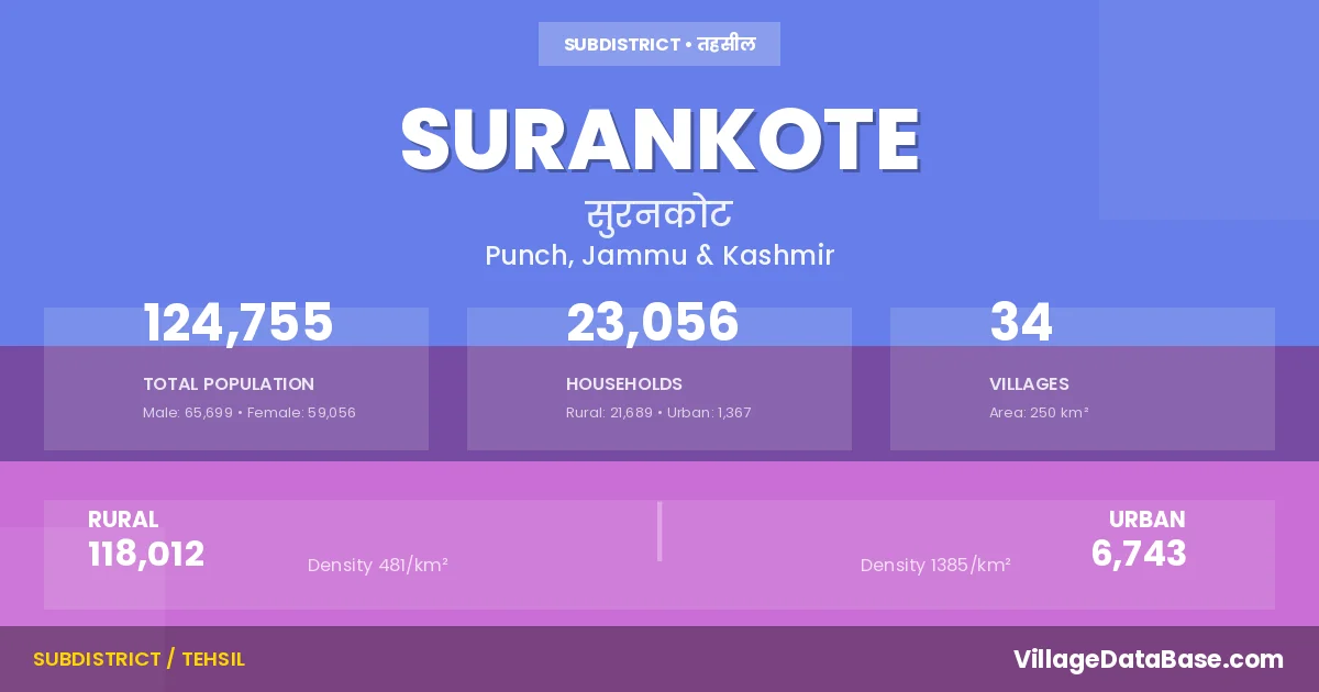
State → Jammu & Kashmir
Surankote is a town and Tehsil in the Punch district of the Jammu & Kashmir. In India, a Tehsil is a subdivision of a district responsible for the administration and revenue collection of a specific area within the district. Tehsils play a crucial role in the local governance structure, contributing significantly to the development and administration of their communities.
According to the 2011 census The total area of Surankote Tehsil is 250 km², with a population of 124755 people. The population density is 499 inhabitants per square kilometre, and there are approximately 23056 houses in the sub district.
Surankote Tehsil comprises about 34 villages. Below is a list of these villages along with information about their respective gram panchayats and the nearest town:
| # | Village Name | Gram Panchayat | Nearest Town |
|---|---|---|---|
| 1 | Bafliaz | Buffliaz A | Surankote (38 km) |
| 2 | Behrangala | Behramgala | Surankote (23 km) |
| 3 | Buni Khet | Bhunikhet | Surankote (33 km) |
| 4 | Chananser | Sailan | Surankote (6 km) |
| 5 | Chandi Marh | Chandimarh | Surankote (22 km) |
| 6 | Dandi Dhara | Dandi Dhara | Surankote (7 km) |
| 7 | Daraba | Draba | Surankote (4 km) |
| 8 | Dhara Mohara | Dhara Mohra | Surankote (12 km) |
| 9 | Dodi | Dodi | Surankote (16 km) |
| 10 | Dogey | Dogran Lower | Surankote (28 km) |
| 11 | Dundhak | Dundak | Surakote (4 km) |
| 12 | Fazal Abad | Fazalabad Bhatair | Surankote (35 km) |
| 13 | Forest Block | Buffliaz A | Surankote (21 km) |
| 14 | Gaunthal | Gunthal Lower | Surankote (6 km) |
| 15 | Hari | Hari Lower | Surankote (12 km) |
| 16 | Kalar Kattal | Kallar Kattal | Surankote (35 km) |
| 17 | Lassana | Lassana Lower | Surankote (6 km) |
| 18 | Lathung | Lathoung | Surankote (6 km) |
| 19 | Mahara | Mahara | Surankote (43 km) |
| 20 | Malhan | Malhan | Surankote (12 km) |
| 21 | Marhote | Marhote Lower Left | Surankote (13 km) |
| 22 | Mohra Bachhai | Mohra Bachhai Lower | Surankote (8 km) |
| 23 | Morha | Murrah Lower Kulali | Surankote (5 km) |
| 24 | Pamrote | Pamrote | Surankote (33 km) |
| 25 | Phagla | Phagla | Surankote (10 km) |
| 26 | Poshiana | Poshana | Surankote (31 km) |
| 27 | Potha | Potha Lower | Surankote |
| 28 | Sailan | Sailan | Surankote (43 km) |
| 29 | Samote | Surankote (31 km) | |
| 30 | Sanei | Sanai Lower | Surankote (3 km) |
| 31 | Sangla | Dara Sangla | Surankote (10 km) |
| 32 | Sangliani | Sanglani | Surankote (4 km) |
| 33 | Surankot | Surankote Lower | Surankote |
| 34 | Traran Wali | Tarranwali | Surankote (4 km) |
The population is distributed between urban and rural areas as follows:
| Particulars | Rural | Urban | Total |
|---|---|---|---|
| Total Population | 118012 | 6743 | 124755 |
| Male Population | 62158 | 3541 | 65699 |
| Female Population | 55854 | 3202 | 59056 | Population Density | 481 / km² | 1385 / km² | 499 / km² |
The distribution of households in the Surankote is:
| Rural Households | Urban Households | Total Households |
|---|---|---|
| 21689 | 1367 | 23056 |
Q: What is Surankote?
A: Surankote is a town and in the Punch district of the Jammu & Kashmir.
Q: What is the total area of Surankote Tehsil?
A: The total area of Surankote Tehsil is 250 km².
Q: What is the population of Surankote Tehsil according to the 2011 census?
A: According to the 2011 census, the population of Surankote Tehsil is 124755.
Q: What is the population density of Surankote Tehsil?
A: The population density of Surankote Tehsil is 499 inhabitants per square kilometre.
Q: How many houses are there in Surankote Tehsil?
A: There are approximately 23056 houses in Surankote Tehsil.
Q: How many villages are there in Surankote Tehsil?
A: There are about 34 villages in Surankote Tehsil.
Q: Which is the largest village by population in Surankote Tehsil?
A: The largest village by population in Surankote Tehsil is Fazal Abad, with 8044 people.
Q: Which is the smallest village by population in Surankote Tehsil?
A: The smallest village by population in Surankote Tehsil is Forest Block, with 0 people.
Q: Which is the largest village by area in Surankote Tehsil?
A: The largest village by area in Surankote Tehsil is Morha, with 2429 km².
Q: Which is the smallest village by area in Surankote Tehsil?
A: The smallest village by area in Surankote Tehsil is Forest Block, with 0 km².
Q: What is the male population of Surankote Tehsil?
A: The male population of Surankote Tehsil is 65699.
Q: What is the female population of Surankote Tehsil?
A: The female population of Surankote Tehsil is 59056.
Q: How many villages in Surankote Tehsil have a population of less than 100?
A: There are 1 villages in Surankote Tehsil with a population of less than 100.
Q: How many villages in Surankote Tehsil have a population between 500 and 999?
A: There are 3 villages in Surankote Tehsil with a population between 500 and 999.
Q: How many villages in Surankote Tehsil have a population between 1000 and 1999?
A: There are 6 villages in Surankote Tehsil with a population between 1000 and 1999.
Q: How many villages in Surankote Tehsil have a population between 2000 and 2999?
A: There is 5 village in Surankote Tehsil with a population between 2000 and 2999.
Q: How many villages in Surankote Tehsil have a population between 3000 and 3999?
A: There is 7 village in Surankote Tehsil with a population between 3000 and 3999.
Q: How many villages in Surankote Tehsil have a population between 4000 and 4999?
A: There is 5 village in Surankote Tehsil with a population between 4000 and 4999.
Q: How many villages in Surankote Tehsil have a population of 5000 and above?
A: There is 7 village in Surankote Tehsil with a population of 5000 and above.
| Total Population | Villages in Sub District Of Surankote |
|---|---|
| Less than 100 | 1 |
| 500-999 | 3 |
| 1000-1999 | 6 |
| 2000-2999 | 5 |
| 3000-3999 | 7 |
| 4000-4999 | 5 |
| 5000 And Above | 7 |