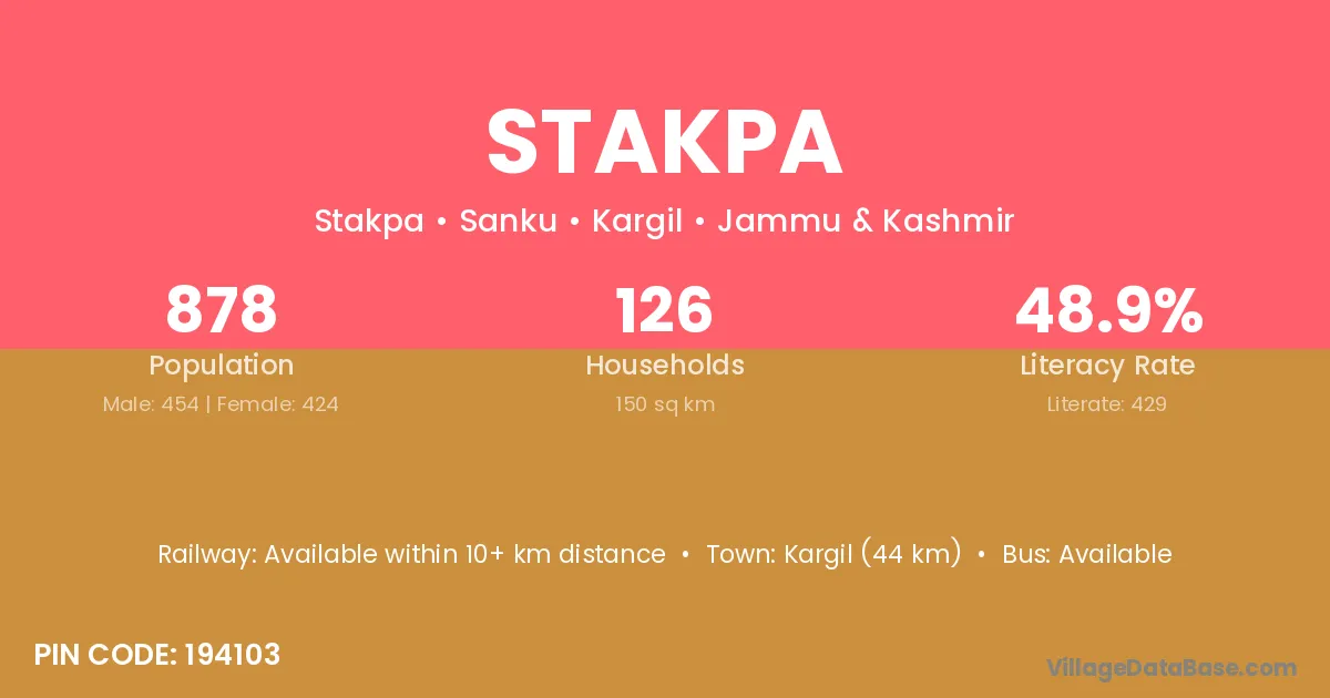
Stakpa village is located in the Sanku Tehsil of the Kargil district in Jammu & Kashmir .
Block / Tehsil → Sanku
District → Kargil
State → Jammu & Kashmir
According to Census 2011 information, the village code of Stakpa village is 194103.
Stakpa village has a total population of 878 people, of which 454 are males and 424 are females.
The literacy rate of Stakpa village is 48.86%. Male literacy stands at 59.69% and female literacy at 37.26%.
There are approximately 126 households in Stakpa village.
Kargil (44 km) is the nearest town to Stakpa village for major economic activities and is located approximately 44 km away.
The population of Stakpa village is distributed between literate and illiterate residents as follows:
| Particulars | Male | Female | Total |
|---|---|---|---|
| Literate | 271 | 158 | 429 |
| Illiterate | 183 | 266 | 449 |
| Total | 454 | 424 | 878 |
Source: Census 2011
| Village | District |
|---|---|
| Barsoo | Ganderbal |
| Barsoo | Kargil |
| Barto | Mandi |
| Barto | Kargil |
| Itchoo | Kargil |
| Karchey Khar | Kargil |
| Karpo Khar | Kargil |
| Lankarchey | Kargil |
| Nagmakusar | Kargil |
| Sangra | Raigarh |
| Sangra | Banas Kantha |
| Sangra | Kargil |
| Sangra | Kapurthala |
| Shergandi | Kargil |
| Thang Dumbur | Kargil |
| Umba | Junagadh |
| Umba | Kheda |
| Umba | Kargil |
No reviews yet. Be the first to review this village!
Available within 10+ km distance
Available within 10+ km distance
Available within village