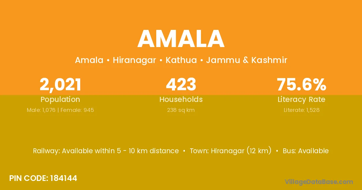
Amala village is located in the Hiranagar Tehsil of the Kathua district in Jammu & Kashmir .
Block / Tehsil → Hiranagar
District → Kathua
State → Jammu & Kashmir
According to Census 2011 information, the village code of Amala village is 184144.
Amala village has a total population of 2,021 people, of which 1,076 are males and 945 are females.
The literacy rate of Amala village is 75.61%. Male literacy stands at 80.20% and female literacy at 70.37%.
There are approximately 423 households in Amala village.
Hiranagar (12 km) is the nearest town to Amala village for major economic activities and is located approximately 12 km away.
The population of Amala village is distributed between literate and illiterate residents as follows:
| Particulars | Male | Female | Total |
|---|---|---|---|
| Literate | 863 | 665 | 1,528 |
| Illiterate | 213 | 280 | 493 |
| Total | 1,076 | 945 | 2,021 |
Source: Census 2011
| Village | District |
|---|---|
| Balaahr | Kathua |
| Bann | Kathua |
| Chhan Rorian | Kathua |
| Dhaloti | Kathua |
| Dhamaal | Kathua |
| Dhandiyari | Kathua |
| Gurah Suraj | Kathua |
| Hamir Pur | Doda |
| Hamir Pur | Kathua |
| Hamir Pur | Farrukhabad |
| Hamir Pur | Kannauj |
| Hamir Pur | Kannauj |
| Rakh Sarkar Jar Bagni | Kathua |
| Sande Chak | Kathua |
| Thath | Kathua |
No reviews yet. Be the first to review this village!
Available within 5 - 10 km distance
Available within <5 km distance
Available within <5 km distance