Welcome Back

Forgot password?
Don't have an account?
🏘️ Menu
Bangalore District 0.0 / 5 (0)

Jangal Palya Village Detailed Information

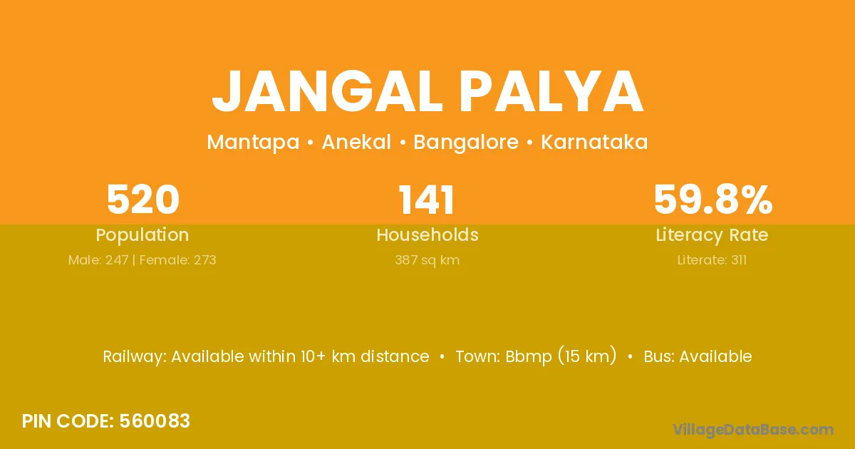
Jangal Palya village is located in the Anekal Taluka of the Bangalore district in Karnataka .

About Jangal Palya Village

Block / Taluka → Anekal

District → Bangalore

State → Karnataka

According to Census 2011 information, the village code of Jangal Palya village is 560083.

Jangal Palya village has a total population of 520 people, of which 247 are males and 273 are females.

The literacy rate of Jangal Palya village is 59.81%. Male literacy stands at 65.59% and female literacy at 54.58%.

There are approximately 141 households in Jangal Palya village.

Bbmp (15 km) is the nearest town to Jangal Palya village for major economic activities and is located approximately 15 km away.

Population of Jangal Palya Village

The population of Jangal Palya village is distributed between literate and illiterate residents as follows:

Population distribution of Jangal Palya village by literacy and gender
Particulars Male Female Total
Literate 162 149 311
Illiterate 85 124 209
Total 247 273 520

Source: Census 2011

Nearby Villages

List of nearby villages around Jangal Palya village
Village District
Laxmipura Banas Kantha
Laxmipura Mahesana
Laxmipura Mahesana
Begihalli Bangalore
Bujangadasanakere Bangalore
Halesampigehalli Bangalore
Hullahalli Bangalore
Hullukasavanahalli Bangalore
Kalkere Bangalore
Laxmipura Bangalore
Mantapa Bangalore
Nallasandra Bangalore
Sakalawara Bangalore
Vaderahalli Bangalore
Vaderahalli Bangalore Rural
Kalkere Chikmagalur
Laxmipura Chikmagalur
Vaderahalli Chikmagalur
Vaderahalli Chitradurga
Kalkere Chitradurga
Vaderahalli Chitradurga
Kalkere Chitradurga
Vaderahalli Chitradurga
Kalkere Davanagere
Kalkere Davanagere
Vaderahalli Davanagere
Laxmipura Davanagere
Vaderahalli Davanagere
Hullahalli Hassan
Laxmipura Hassan
Vaderahalli Hassan
Laxmipura Hassan
Vaderahalli Hassan
Kalkere Hassan
Hullahalli Hassan
Laxmipura Hassan
Hullahalli Hassan
Kalkere Kolar
Kalkere Kolar
Laxmipura Mandya
Hullahalli Mandya
Hullahalli Mandya
Laxmipura Mandya
Vaderahalli Mandya
Vaderahalli Mysore
Laxmipura Mysore
Laxmipura Mysore
Hullahalli Mysore
Kalkere Mysore
Laxmipura Mysore
Vaderahalli Ramanagara
Kalkere Ramanagara
Vaderahalli Tumkur
Kalkere Tumkur
Vaderahalli Tumkur
Vaderahalli Tumkur
Kalkere Tumkur
Vaderahalli Tumkur
Kalkere Tumkur
Vaderahalli Tumkur
Kalkere Tumkur
Vaderahalli Tumkur
Laxmipura Ashoknagar
Laxmipura Bhind
Laxmipura Dewas
Laxmipura Dewas
Laxmipura Guna
Laxmipura Rajgarh
Laxmipura Rajgarh
Laxmipura Ratlam
Laxmipura Shivpuri
Laxmipura Ujjain
Laxmipura Ajmer
Laxmipura Ajmer
Laxmipura Ajmer
Laxmipura Ajmer
Laxmipura Banswara
Laxmipura Baran
Laxmipura Baran
Laxmipura Barmer
Laxmipura Bhilwara
Laxmipura Bhilwara
Laxmipura Bhilwara
Laxmipura Bhilwara
Laxmipura Bundi
Laxmipura Bundi
Laxmipura Bundi
Laxmipura Chittaurgarh
Laxmipura Jaipur
Laxmipura Jaipur
Laxmipura Jaipur
Laxmipura Jaipur
Laxmipura Jhalawar
Laxmipura Jhalawar
Laxmipura Jhalawar
Laxmipura Kota
Laxmipura Kota
Laxmipura Kota
Laxmipura Kota
Laxmipura Rajsamand
Laxmipura Rajsamand
Laxmipura Rajsamand
Laxmipura Sawai Madhopur
Laxmipura Tonk
Laxmipura Tonk
Laxmipura Tonk
Laxmipura Udaipur

Frequently Asked Questions

Jangal Palya village is located in the Anekal Taluka of the Bangalore district in Karnataka.
The total population is 520 people.
247 males and 273 females.
The literacy rate is 59.81%.
Male literacy rate is 65.59%, and female literacy rate is 54.58%.
There are approximately 141 houses in Jangal Palya village.
Bbmp (15 km) is the nearest town, located approximately 15 km away.

Reviews and Ratings

0.0 / 5 (0 reviews)

Reviews

No reviews yet. Be the first to review this village!

Jangal Palya Village Statistics

Population
520
Area
387 km²
Households
141
Nearest Town :
Bbmp (15 km)

Quick Information

State / UT : Karnataka
Pincode : 560083
Total Area : 387 km²
Population : 520
Households : 141
Gram Panchayat : Mantapa
Nearest Town : Bbmp (15 km)

Connectivity of Jangal Palya

🚂 Railway Station

Available within 10+ km distance

🚌 Public Bus Service

Available within village

🚌 Private Bus Service

Available within village

Need Help?

Contact local tourism office for assistance