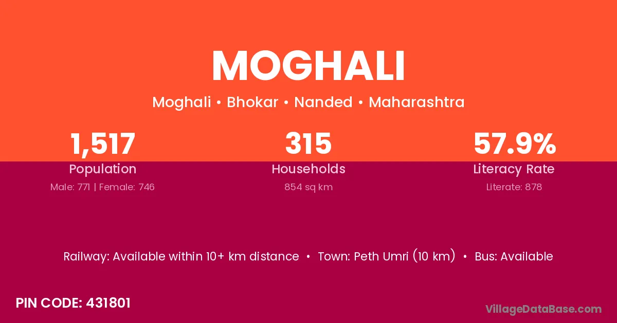
Moghali village is located in the Bhokar Tehsil of the Nanded district in Maharashtra .
Block / Tehsil → Bhokar
District → Nanded
State → Maharashtra
According to Census 2011 information, the village code of Moghali village is 431801.
Moghali village has a total population of 1,517 people, of which 771 are males and 746 are females.
The literacy rate of Moghali village is 57.88%. Male literacy stands at 65.76% and female literacy at 49.73%.
There are approximately 315 households in Moghali village.
Peth Umri (10 km) is the nearest town to Moghali village for major economic activities and is located approximately 10 km away.
The population of Moghali village is distributed between literate and illiterate residents as follows:
| Particulars | Male | Female | Total |
|---|---|---|---|
| Literate | 507 | 371 | 878 |
| Illiterate | 264 | 375 | 639 |
| Total | 771 | 746 | 1,517 |
Source: Census 2011
| Village | District |
|---|---|
| Ballal | Nanded |
| Bendri | Durg |
| Bendri | Raipur |
| Bendri | Raipur |
| Bendri | Rajnandgaon |
| Bendri | Chhatarpur |
| Bendri | Shivpuri |
| Bendri | Nanded |
| Bendri | Nanded |
| Bendri | Sangli |
| Dharjani | Nanded |
| Hadoli | Latur |
| Hadoli | Latur |
| Hadoli | Nanded |
| Hadoli | Dausa |
| Hadoli | Karauli |
| Halda | Kishanganj |
| Halda | Bastar |
| Halda | Solan |
| Halda | Aurangabad |
| Halda | Chandrapur |
| Halda | Nanded |
| Halda | Nanded |
| Halda | Washim |
| Halda | Mayurbhanj |
| Halda | Adilabad |
| Ilegaon Patti Bhokar | Nanded |
| Kamangaon | Nanded |
| Lamkani | Akola |
| Lamkani | Dhule |
| Lamkani | Nanded |
| Lamkani | Balangir |
| Nanda Bk | Nanded |
| Shivangaon | Jalna |
| Shivangaon | Nanded |
| Shivangaon | Nashik |
| Shivangaon | Wardha |
| Sindhi | Barwani |
| Sindhi | Bhandara |
| Sindhi | Nanded |
| Sindhi | Yavatmal |
| Sindhi | Kandhamal |
No reviews yet. Be the first to review this village!
Available within 10+ km distance
Available within village
Available within 10+ km distance