District → Parbhani
State → Maharashtra
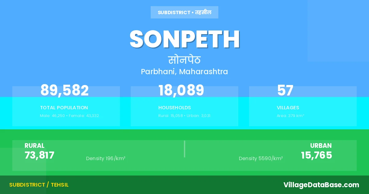
Sonpeth is a town and Tehsil in the Parbhani district of the Maharashtra. In India, a Tehsil is a subdivision of a district responsible for the administration and revenue collection of a specific area within the district. Tehsils play a crucial role in the local governance structure, contributing significantly to the development and administration of their communities.
According to the 2011 census The total area of Sonpeth Tehsil is 379 km², with a population of 89582 people. The population density is 237 inhabitants per square kilometre, and there are approximately 18089 houses in the sub district.
Sonpeth Tehsil comprises about 57 villages. Below is a list of these villages along with information about their respective gram panchayats and the nearest town:
| # | Village Name | Gram Panchayat | Nearest Town |
|---|---|---|---|
| 1 | Awalgaon | Awalgaon | Sonpeth (18 km) |
| 2 | Bhaucha Tanda | Shelgaon Maratha | Sonpeth (8 km) |
| 3 | Bhisegaon | Bhisegaon | Sonpeth (16 km) |
| 4 | Bondargaon | Bondargaon | Sonpeth (14 km) |
| 5 | Buktarwadi | Buktarwadi | Parli (15 km) |
| 6 | Chukar Pimpri | Chukar Pimpri | Sonpeth (20 km) |
| 7 | Devinagar Tanda | Devinagar Tanda | Sonpeth (16 km) |
| 8 | Dhamoni | Dhamoni | Sonpeth (17 km) |
| 9 | Dhardighol | Dhar Dighol | Sonpeth (10 km) |
| 10 | Dighol Islampur | Dighol Islampur | Sonpeth (6 km) |
| 11 | Dobadi Tanda | Kanhegaon | Gangakhed (26 km) |
| 12 | Dudhgaon | Dudhgaon | Sonpeth (3 km) |
| 13 | Ganga Pimpri | Ganga Pimpri | Sonpeth (15 km) |
| 14 | Gauli Pimpri | Gawali Pimpri | Sonpeth (3 km) |
| 15 | Golegaon | Ganga Pimpri | Sonpeth (17 km) |
| 16 | Kanhegaon | Kanhegaon | Gangakhed (23 km) |
| 17 | Karam | Karam | Sonpeth (24 km) |
| 18 | Khadka | Khadaka | Gangakhed (20 km) |
| 19 | Khapat Pimpri | Khapat Pimpri | Sonpeth (4 km) |
| 20 | Kortek | Kortek | Gangakhed (12 km) |
| 21 | Kothala | Kothala | Sonpeth (12 km) |
| 22 | Kothala Tanda | Kothala | Sonpeth (13 km) |
| 23 | Lasina | Lasina | Sonpeth (10 km) |
| 24 | Lohigram | Lohigram | Sonpeth (15 km) |
| 25 | Lohigram Tanda | Lohigram | Sonpeth (12 km) |
| 26 | Mansiram Tanda | Devinagar Tanda | Sonpeth (16 km) |
| 27 | Margalwadi | Wadgaon | Gangakhed (12 km) |
| 28 | Mohala | Mohala | Gangakhed (19 km) |
| 29 | Naikota | Naikota | Gangakhed (20 km) |
| 30 | Narwadi | Narwadi | Sonpeth (10 km) |
| 31 | Nila | Nila | Gangakhed (15 km) |
| 32 | Nimgaon | Nimgaon | Sonpeth (6 km) |
| 33 | Paradhwadi | Paradhwadi | Parli (10 km) |
| 34 | Pohandul | Pohondul | Gangakhed (16 km) |
| 35 | Pohandul Tanda | Pohondul | Gangakhed (13 km) |
| 36 | Rewa Tanda | Dighol Islampur | Gangakhed (45 km) |
| 37 | Saikheda | Saikheda | Sonpeth (16 km) |
| 38 | Sakharam Tanda | Shrisi Budruk | Sonpeth (11 km) |
| 39 | Shelgaon Hatkar | Shelgaon Maratha | Sonpeth (10 km) |
| 40 | Shelgaon Maratha | Shelgaon Maratha | Sonpeth (10 km) |
| 41 | Sirori | Shirori | Sonpeth (18 km) |
| 42 | Sirsi Bk | Shrisi Budruk | Sonpeth (20 km) |
| 43 | Thadi Pimpalgaon | Thadi Pimpalgaon | Sonpeth (14 km) |
| 44 | Thadiukkadgaon | Thadi Ukkadgaon | Sonpeth (12 km) |
| 45 | Tiwathana | Tiwthana | Gangakhed (10 km) |
| 46 | Tukai Tanda | Saikheda | Sonpeth (16 km) |
| 47 | Ukhali Bk | Ukhali Budruk | Parli (12 km) |
| 48 | Ukhali Tanda | Paradhwadi | Parli (10 km) |
| 49 | Ukkadgaon Makta | Ukkadgaon Makta | Gangakhed (20 km) |
| 50 | Vita Kh | Vita Khurd | Sonpeth (4 km) |
| 51 | Wadgaon | Wadgaon | Gangakhed (13 km) |
| 52 | Wadi Naikata | Bondargaon | Gangakhed (20 km) |
| 53 | Wadi Pimpalgaon | Wadi Pimpalgaon | Sonpeth (13 km) |
| 54 | Waghalgaon | Vita Khurd | Sonpeth (6 km) |
| 55 | Waitagwadi | Waitagwadi | Gangakhed (12 km) |
| 56 | Wandan | Wandan | Gangakhed (16 km) |
| 57 | Wanisangam | Wanisangam | Sonpeth (3 km) |
The population is distributed between urban and rural areas as follows:
| Particulars | Rural | Urban | Total |
|---|---|---|---|
| Total Population | 73817 | 15765 | 89582 |
| Male Population | 38130 | 8120 | 46250 |
| Female Population | 35687 | 7645 | 43332 | Population Density | 196 / km² | 5590 / km² | 237 / km² |
The distribution of households in the Sonpeth is:
| Rural Households | Urban Households | Total Households |
|---|---|---|
| 15058 | 3031 | 18089 |
Q: What is Sonpeth?
A: Sonpeth is a town and in the Parbhani district of the Maharashtra.
Q: What is the total area of Sonpeth Tehsil?
A: The total area of Sonpeth Tehsil is 379 km².
Q: What is the population of Sonpeth Tehsil according to the 2011 census?
A: According to the 2011 census, the population of Sonpeth Tehsil is 89582.
Q: What is the population density of Sonpeth Tehsil?
A: The population density of Sonpeth Tehsil is 237 inhabitants per square kilometre.
Q: How many houses are there in Sonpeth Tehsil?
A: There are approximately 18089 houses in Sonpeth Tehsil.
Q: How many villages are there in Sonpeth Tehsil?
A: There are about 57 villages in Sonpeth Tehsil.
Q: Which is the largest village by population in Sonpeth Tehsil?
A: The largest village by population in Sonpeth Tehsil is Dighol Islampur, with 3605 people.
Q: Which is the smallest village by population in Sonpeth Tehsil?
A: The smallest village by population in Sonpeth Tehsil is Golegaon, with 183 people.
Q: Which is the largest village by area in Sonpeth Tehsil?
A: The largest village by area in Sonpeth Tehsil is Dighol Islampur, with 2538 km².
Q: Which is the smallest village by area in Sonpeth Tehsil?
A: The smallest village by area in Sonpeth Tehsil is Golegaon, with 153 km².
Q: What is the male population of Sonpeth Tehsil?
A: The male population of Sonpeth Tehsil is 46250.
Q: What is the female population of Sonpeth Tehsil?
A: The female population of Sonpeth Tehsil is 43332.
Q: How many villages in Sonpeth Tehsil have a population between 100 and 499?
A: There are 11 villages in Sonpeth Tehsil with a population between 100 and 499.
Q: How many villages in Sonpeth Tehsil have a population between 500 and 999?
A: There are 15 villages in Sonpeth Tehsil with a population between 500 and 999.
Q: How many villages in Sonpeth Tehsil have a population between 1000 and 1999?
A: There are 19 villages in Sonpeth Tehsil with a population between 1000 and 1999.
Q: How many villages in Sonpeth Tehsil have a population between 2000 and 2999?
A: There is 8 village in Sonpeth Tehsil with a population between 2000 and 2999.
Q: How many villages in Sonpeth Tehsil have a population between 3000 and 3999?
A: There is 4 village in Sonpeth Tehsil with a population between 3000 and 3999.
| Total Population | Villages in Sub District Of Sonpeth |
|---|---|
| 100-499 | 11 |
| 500-999 | 15 |
| 1000-1999 | 19 |
| 2000-2999 | 8 |
| 3000-3999 | 4 |