Welcome Back

Forgot password?
Don't have an account?
🏘️ Menu
Pune District 0.0 / 5 (0)

Charholi Kh Village Detailed Information

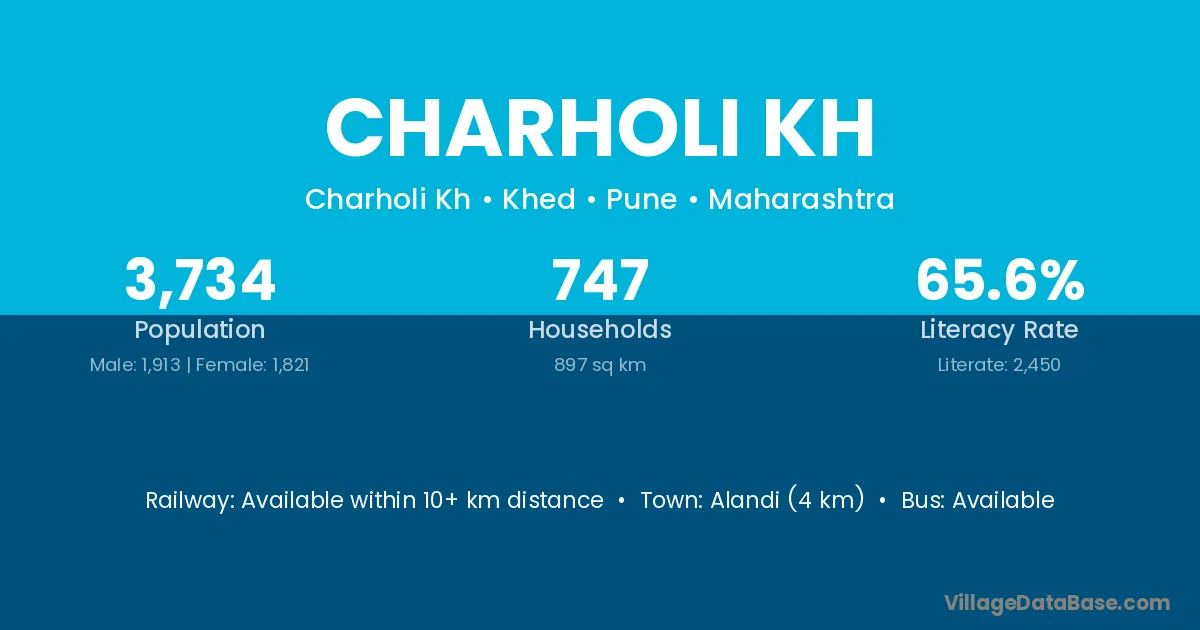
Charholi Kh village is located in the Khed Tehsil of the Pune district in Maharashtra .

About Charholi Kh Village

Block / Tehsil → Khed

District → Pune

State → Maharashtra

Charholi Kh village has a total population of 3,734 people, of which 1,913 are males and 1,821 are females.

The literacy rate of Charholi Kh village is 65.61%. Male literacy stands at 70.94% and female literacy at 60.02%.

There are approximately 747 households in Charholi Kh village.

Alandi (4 km) is the nearest town to Charholi Kh village for major economic activities and is located approximately 4 km away.

Population of Charholi Kh Village

The population of Charholi Kh village is distributed between literate and illiterate residents as follows:

Population distribution of Charholi Kh village by literacy and gender
Particulars Male Female Total
Literate 1,357 1,093 2,450
Illiterate 556 728 1,284
Total 1,913 1,821 3,734

Source: Census 2011

Nearby Villages

List of nearby villages around Charholi Kh village
Village District
Chakan Sirsa
Chakan Pune
Chakan Mansa
Dhanore Kathua
Dhanore Ahmadnagar
Dhanore Akola
Dhanore Jalgaon
Dhanore Jalgaon
Dhanore Nandurbar
Dhanore Nashik
Dhanore Nashik
Dhanore Pune
Dhanore Pune
Dhanore Solapur
Dhanore Solapur
Dhanore Solapur
Golegaon Ahmadnagar
Golegaon Akola
Golegaon Amravati
Golegaon Amravati
Golegaon Aurangabad
Golegaon Aurangabad
Golegaon Bid
Golegaon Buldana
Golegaon Hingoli
Golegaon Jalna
Golegaon Nanded
Golegaon Nanded
Golegaon Nanded
Golegaon Nashik
Golegaon Osmanabad
Golegaon Osmanabad
Golegaon Parbhani
Golegaon Pune
Golegaon Pune
Golegaon Pune
Golegaon Satara
Kharabwadi Latur
Kharabwadi Pune
Markal Chikmagalur
Markal Yadgir
Markal Gadchiroli
Markal Pune
Markal Rangareddy
Medankarwadi Pune
Nanekarwadi Pune
Pimpalgaon Tarf Chakan Pune
Rajgurunagar Pune
Sawale Pune
Solu Pune

Frequently Asked Questions

Charholi Kh village is located in the Khed Tehsil of the Pune district in Maharashtra.
The total population is 3,734 people.
1,913 males and 1,821 females.
The literacy rate is 65.61%.
Male literacy rate is 70.94%, and female literacy rate is 60.02%.
There are approximately 747 houses in Charholi Kh village.
Alandi (4 km) is the nearest town, located approximately 4 km away.

Reviews and Ratings

0.0 / 5 (0 reviews)

Reviews

No reviews yet. Be the first to review this village!

Charholi Kh Village Statistics

Population
3734
Area
897 km²
Households
747
Nearest Town :
Alandi (4 km)

Quick Information

State / UT : Maharashtra
Total Area : 897 km²
Population : 3734
Households : 747
Gram Panchayat : Charholi Kh
Nearest Town : Alandi (4 km)

Connectivity of Charholi Kh

🚂 Railway Station

Available within 10+ km distance

🚌 Public Bus Service

Available within village

🚌 Private Bus Service

Available within <5 km distance

Need Help?

Contact local tourism office for assistance