Ambarnath: A Town and Tehsil in Thane district
District → Thane
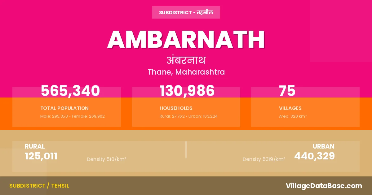
State → Maharashtra
Ambarnath is a town and Tehsil in the Thane district of the Maharashtra. In India, a Tehsil is a subdivision of a district responsible for the administration and revenue collection of a specific area within the district. Tehsils play a crucial role in the local governance structure, contributing significantly to the development and administration of their communities.
According to the 2011 census The total area of Ambarnath Tehsil is 328 km², with a population of 565340 people. The population density is 1,723 inhabitants per square kilometre, and there are approximately 130986 houses in the sub district.
Ambarnath Tehsil comprises about 75 villages. Below is a list of these villages along with information about their respective gram panchayats and the nearest town:
| # | Village Name | Gram Panchayat | Nearest Town |
|---|---|---|---|
| 1 | Adivali Dhokali | Kalyan (17 km) | |
| 2 | Ambarnath | Ambarnath | |
| 3 | Ambeshiv Bk | Abeshiv | Badlapur (8 km) |
| 4 | Ambeshiv Kh | Dhoke | Badlapur (8 km) |
| 5 | Ambhe | Kharad | Kalyan (16 km) |
| 6 | Amboshi | Posari | Ambarnath |
| 7 | Ashele | Ulhasnagar (6 km) | |
| 8 | Asnoli | Asnoli | Badlapur (12 km) |
| 9 | Asode | Burdul | Ambarnath |
| 10 | Bandhanwadi | Wadi | Kalyan (17 km) |
| 11 | Bendshil | Chamtoli | Badlapur (6 km) |
| 12 | Bhal | Kalyan (6 km) | |
| 13 | Bhoj | Dahivali | Badlapur (5 km) |
| 14 | Bohonoli | Mangarul | Ambarnath (7 km) |
| 15 | Burdul | Burdul | Kalyan-dombivli (17 km) |
| 16 | Chamtoli | Chamtoli | Badlapur (4 km) |
| 17 | Chandap | Sagaon | Badlapur (20 km) |
| 18 | Chargaon | Chargoan | Badlapur (12 km) |
| 19 | Chinchavali | Chamtoli | Badlapur (10 km) |
| 20 | Chinchavali Bk | Nevali | Kalyan (10 km) |
| 21 | Chinchpada | Kalyan-dombivli (3 km) | |
| 22 | Chirad | Posari | Ambarnath (15 km) |
| 23 | Chon | Chon | Badlapur (8 km) |
| 24 | Dahivali | Dahivali | Badlapur (4 km) |
| 25 | Dapivali | Dhoke | Badlapur (8 km) |
| 26 | Dawrali | Kalyan (4 km) | |
| 27 | Devaloli | Savare | Badlapur (3 km) |
| 28 | Dhavale | Dhavle | Badlapur (10 km) |
| 29 | Dhoke | Kharad | Kalyan (16 km) |
| 30 | Done | Done | Badlapur (13 km) |
| 31 | Goregaon | Goregoan | Badlapur (7 km) |
| 32 | Gorpe | Mangarul | Ambarnath (4 km) |
| 33 | Indgaon | Karav | Badlapur (12 km) |
| 34 | Jambhale | Savare | Badlapur (5 km) |
| 35 | Jambhilghar | Rahatoli | Badlapur (7 km) |
| 36 | Kakadwal | Nevali | Kalyan (14 km) |
| 37 | Kakole | Kakole | Ambarnath (6 km) |
| 38 | Kanhor | Kanhor | Badlapur (8 km) |
| 39 | Karand | Chon | Badlapur (17 km) |
| 40 | Karav | Karav | Badlapur (8 km) |
| 41 | Karavale Kh | Narhen | Kalyan (14 km) |
| 42 | Kasgaon | Kasgoan | Badlapur (6 km) |
| 43 | Kharad | Kharad | Kalyan (15 km) |
| 44 | Khuntavali | Dahivali | Ambarnath |
| 45 | Kudsavare | Dhavle | Badlapur (13 km) |
| 46 | Kumbharli | Narhen | Kalyan (17 km) |
| 47 | Kushivali | Kharad | Kalyan (17 km) |
| 48 | Manere | Ulhasnagar (6 km) | |
| 49 | Mangrul | Mangarul | Kalyan (13 km) |
| 50 | Mulgaon | Mulgaon | Badlapur (8 km) |
| 51 | Narhen | Narhen | Kalyan-dombivli (16 km) |
| 52 | Nevali | Nevali | Ambarnath (7 km) |
| 53 | Pachon | Abeshiv | Badlapur (9 km) |
| 54 | Padirpada | Sagaon | Badlapur (15 km) |
| 55 | Pali | Posari | Kalyan (10 km) |
| 56 | Pimploli | Asnoli | Badlapur (16 km) |
| 57 | Posari | Posari | Kalyan (15 km) |
| 58 | Rahatoli | Rahatoli | Badlapur (3 km) |
| 59 | Sagaon | Sagaon | Badlapur (15 km) |
| 60 | Sai | Sai | Kalyan-dombivli (5 km) |
| 61 | Sakharoli | Wadi | Ambarnath |
| 62 | Sape | Dahivali | Badlapur (3 km) |
| 63 | Savare | Savare | Badlapur (4 km) |
| 64 | Savaroli | Dahivali | Badlapur (9 km) |
| 65 | Shil | Karav | Badlapur (15 km) |
| 66 | Shiravali | Mangarul | Kalyan (17 km) |
| 67 | Sonavale | Mulgaon | Badlapur (9 km) |
| 68 | Tan | Chamtoli | Badlapur (6 km) |
| 69 | Umbroli | Dombivali (6 km) | |
| 70 | Usatane | Usatne | Kalyan (16 km) |
| 71 | Vangani | Wangani | Ambarnath |
| 72 | Varade | Dahivali | Badlapur (7 km) |
| 73 | Wadi | Wadi | Kalyan (17 km) |
| 74 | Wasar | Kalyan-dombivli (6 km) | |
| 75 | Yeve | Asnoli | Badlapur (15 km) |
The population is distributed between urban and rural areas as follows:
| Particulars | Rural | Urban | Total |
|---|---|---|---|
| Total Population | 125011 | 440329 | 565340 |
| Male Population | 65804 | 229554 | 295358 |
| Female Population | 59207 | 210775 | 269982 | Population Density | 510 / km² | 5319 / km² | 1,723 / km² |
The distribution of households in the Ambarnath is:
| Rural Households | Urban Households | Total Households |
|---|---|---|
| 27762 | 103224 | 130986 |
Q: What is Ambarnath?
A: Ambarnath is a town and in the Thane district of the Maharashtra.
Q: What is the total area of Ambarnath Tehsil?
A: The total area of Ambarnath Tehsil is 328 km².
Q: What is the population of Ambarnath Tehsil according to the 2011 census?
A: According to the 2011 census, the population of Ambarnath Tehsil is 565340.
Q: What is the population density of Ambarnath Tehsil?
A: The population density of Ambarnath Tehsil is 1,723 inhabitants per square kilometre.
Q: How many houses are there in Ambarnath Tehsil?
A: There are approximately 130986 houses in Ambarnath Tehsil.
Q: How many villages are there in Ambarnath Tehsil?
A: There are about 75 villages in Ambarnath Tehsil.
Q: Which is the largest village by population in Ambarnath Tehsil?
A: The largest village by population in Ambarnath Tehsil is Ashele, with 22946 people.
Q: Which is the smallest village by population in Ambarnath Tehsil?
A: The smallest village by population in Ambarnath Tehsil is Ambarnath, with 0 people.
Q: Which is the largest village by area in Ambarnath Tehsil?
A: The largest village by area in Ambarnath Tehsil is Chargaon, with 1974 km².
Q: Which is the smallest village by area in Ambarnath Tehsil?
A: The smallest village by area in Ambarnath Tehsil is Ambarnath, with 0 km².
Q: What is the male population of Ambarnath Tehsil?
A: The male population of Ambarnath Tehsil is 295358.
Q: What is the female population of Ambarnath Tehsil?
A: The female population of Ambarnath Tehsil is 269982.
Q: How many villages in Ambarnath Tehsil have a population of less than 100?
A: There are 9 villages in Ambarnath Tehsil with a population of less than 100.
Q: How many villages in Ambarnath Tehsil have a population between 100 and 499?
A: There are 9 villages in Ambarnath Tehsil with a population between 100 and 499.
Q: How many villages in Ambarnath Tehsil have a population between 500 and 999?
A: There are 24 villages in Ambarnath Tehsil with a population between 500 and 999.
Q: How many villages in Ambarnath Tehsil have a population between 1000 and 1999?
A: There are 22 villages in Ambarnath Tehsil with a population between 1000 and 1999.
Q: How many villages in Ambarnath Tehsil have a population between 2000 and 2999?
A: There is 3 village in Ambarnath Tehsil with a population between 2000 and 2999.
Q: How many villages in Ambarnath Tehsil have a population between 3000 and 3999?
A: There is 3 village in Ambarnath Tehsil with a population between 3000 and 3999.
Q: How many villages in Ambarnath Tehsil have a population between 4000 and 4999?
A: There is 1 village in Ambarnath Tehsil with a population between 4000 and 4999.
Q: How many villages in Ambarnath Tehsil have a population of 5000 and above?
A: There is 4 village in Ambarnath Tehsil with a population of 5000 and above.
| Total Population | Villages in Sub District Of Ambarnath |
|---|---|
| Less than 100 | 9 |
| 100-499 | 9 |
| 500-999 | 24 |
| 1000-1999 | 22 |
| 2000-2999 | 3 |
| 3000-3999 | 3 |
| 4000-4999 | 1 |
| 5000 And Above | 4 |