Welcome Back

Forgot password?
Don't have an account?
🏘️ Menu
Yavatmal District 0.0 / 5 (0)

Karanji Road Village Detailed Information

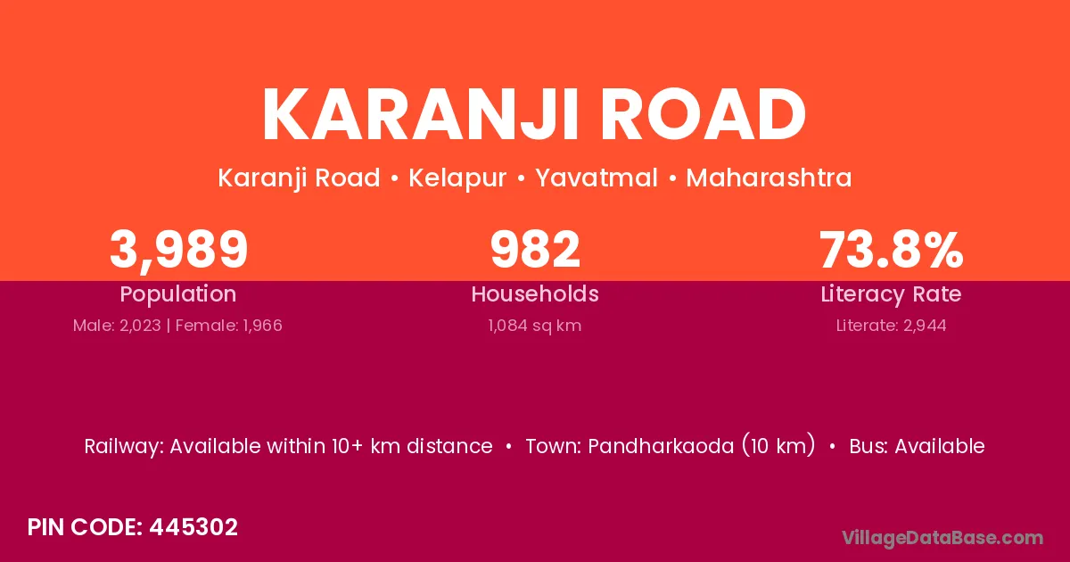
Karanji Road village is located in the Kelapur Tehsil of the Yavatmal district in Maharashtra .

About Karanji Road Village

Block / Tehsil → Kelapur

District → Yavatmal

State → Maharashtra

According to Census 2011 information, the village code of Karanji Road village is 445302.

Karanji Road village has a total population of 3,989 people, of which 2,023 are males and 1,966 are females.

The literacy rate of Karanji Road village is 73.80%. Male literacy stands at 79.68% and female literacy at 67.75%.

There are approximately 982 households in Karanji Road village.

Pandharkaoda (10 km) is the nearest town to Karanji Road village for major economic activities and is located approximately 10 km away.

Population of Karanji Road Village

The population of Karanji Road village is distributed between literate and illiterate residents as follows:

Population distribution of Karanji Road village by literacy and gender
Particulars Male Female Total
Literate 1,612 1,332 2,944
Illiterate 411 634 1,045
Total 2,023 1,966 3,989

Source: Census 2011

Nearby Villages

List of nearby villages around Karanji Road village
Village District
Adni Yavatmal
Adni Uttarkashi
Chanai Bid
Chanai Yavatmal
Khatara Darrang
Khatara Yavatmal
Kinhala Bhandara
Kinhala Chandrapur
Kinhala Gadchiroli
Kinhala Nagpur
Kinhala Nagpur
Kinhala Nagpur
Kinhala Wardha
Kinhala Wardha
Kinhala Wardha
Kinhala Wardha
Kinhala Wardha
Kinhala Yavatmal
Kinhala Yavatmal
Kinhala Yavatmal
Munzala Yavatmal
Sakhi Bk Yavatmal
Singaldip Pashchimi Singhbhum
Singaldip Yavatmal
Sonurli Chandrapur
Sonurli Chandrapur
Sonurli Chandrapur
Sonurli Kolhapur
Sonurli Nagpur
Sonurli Sindhudurg
Sonurli Yavatmal
Sonurli Yavatmal
Wadhona Bk Nagpur
Wadhona Bk Yavatmal
Wadhona Kh Nagpur
Wadhona Kh Yavatmal
Wadhona Kh Yavatmal
Zolapur Ahmadabad
Zolapur Yavatmal

Frequently Asked Questions

Karanji Road village is located in the Kelapur Tehsil of the Yavatmal district in Maharashtra.
The total population is 3,989 people.
2,023 males and 1,966 females.
The literacy rate is 73.80%.
Male literacy rate is 79.68%, and female literacy rate is 67.75%.
There are approximately 982 houses in Karanji Road village.
Pandharkaoda (10 km) is the nearest town, located approximately 10 km away.

Reviews and Ratings

0.0 / 5 (0 reviews)

Reviews

No reviews yet. Be the first to review this village!

Karanji Road Village Statistics

Population
3989
Area
1084 km²
Households
982
Nearest Town :
Pandharkaoda (10 km)

Quick Information

State / UT : Maharashtra
Pincode : 445302
Total Area : 1084 km²
Population : 3989
Households : 982
Gram Panchayat : Karanji Road
Nearest Town : Pandharkaoda (10 km)

Connectivity of Karanji Road

🚂 Railway Station

Available within 10+ km distance

🚌 Public Bus Service

Available within village

🚌 Private Bus Service

Available within village

Need Help?

Contact local tourism office for assistance