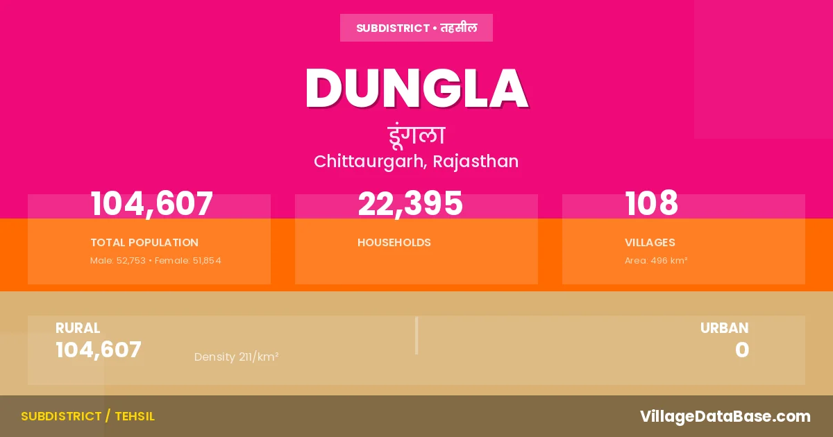
Dungla: A Town and Tehsil in Chittaurgarh district
District → Chittaurgarh
State → Rajasthan
Dungla is a town and Tehsil in the Chittaurgarh district of the Rajasthan. In India, a Tehsil is a subdivision of a district responsible for the administration and revenue collection of a specific area within the district. Tehsils play a crucial role in the local governance structure, contributing significantly to the development and administration of their communities.
According to the 2011 census The total area of Dungla Tehsil is 496 km², with a population of 104607 people. The population density is 211 inhabitants per square kilometre, and there are approximately 22395 houses in the sub district.
Dungla Tehsil comprises about 108 villages. Below is a list of these villages along with information about their respective gram panchayats and the nearest town:
| # | Village Name | Gram Panchayat | Nearest Town |
|---|---|---|---|
| 1 | Ajeetpura | Rawat Pura | Kanor (2 km) |
| 2 | Ala Kheri | Alod | Bari Sadri (13 km) |
| 3 | Alod | Alod | Bari Sadri (11 km) |
| 4 | Anandpura | Alod | Bari Sadri (18 km) |
| 5 | Arned | Arned | Bhinder (13 km) |
| 6 | Arniya | Sangesara | Kapasan (50 km) |
| 7 | Arthala | Semaliya Peelakhera | Kanor (12 km) |
| 8 | Azampura | Morwan | Bhinder (36 km) |
| 9 | Badwai | Badwai | Kanor (8 km) |
| 10 | Bagpura | Arned | Bhinder (12 km) |
| 11 | Beeron Ka Khera | Rawat Pura | Kanor (4 km) |
| 12 | Bhana Kheri | Biloda | Kanor (14 km) |
| 13 | Bhanpa | Rawat Pura | Kanor (3 km) |
| 14 | Bhatoli Bagariyan | Bhatoli Bagriyan | Bari Sadri (25 km) |
| 15 | Bhatoli Goojran | Bhatoli | Bari Sadri (25 km) |
| 16 | Bheela Khera | Morwan | Kapasan (21 km) |
| 17 | Bhoot Khera | Nada Khera | Nimbahera (38 km) |
| 18 | Bhopji Ka Khera | Badwai | Kanor (6 km) |
| 19 | Bhurkiya Khurd | Bilot | Bari Sadri (20 km) |
| 20 | Bihari Pura | Bhatoli | Nimbahera (36 km) |
| 21 | Biloda | Biloda | Bhinder (14 km) |
| 22 | Bilot | Bilot | Bari Sadri (15 km) |
| 23 | Chaktiya | Nangawali | Kanor (31 km) |
| 24 | Chhajvi | Delwas | Kanor (10 km) |
| 25 | Chhapri | Negadiya | Bhinder (14 km) |
| 26 | Chikarda | Chikarda | Nimbahera (25 km) |
| 27 | Daulaipura | Morwan | Kanor (20 km) |
| 28 | Daulatpura | Bhatoli | Kanor (20 km) |
| 29 | Delwas | Delwas | Bari Sadri (20 km) |
| 30 | Deoli | Pirana | Bari Sadri (20 km) |
| 31 | Deva Khera | Bhatoli Bagriyan | Bari Sadri (25 km) |
| 32 | Devipura | Kishan Kareri | Kanor (13 km) |
| 33 | Doongla | Doongla | Kanor (12 km) |
| 34 | Durga Khera | Bilot | Bari Sadri (19 km) |
| 35 | Fateh Chikarda | Doongla | Kanor (12 km) |
| 36 | Gadariyawas | Morwan | Bhinder (23 km) |
| 37 | Garawala | Biloda | Kanor (14 km) |
| 38 | Ghora Khera | Nada Khera | Nimbahera (38 km) |
| 39 | Ghoronka Ka Khera | Rawat Pura | Kanor (2 km) |
| 40 | Gumanpura | Phalodra | Bari Sadri (30 km) |
| 41 | Gurha | Badwai | Kanor (10 km) |
| 42 | Gurjaniya | Karsana | Kanor (9 km) |
| 43 | Hamer Singh Ji Ka Khera | Rawat Pura | Kanor (4 km) |
| 44 | Hariya Kheri | Negadiya | Bhinder (20 km) |
| 45 | Idra | Idra | Bhinder (15 km) |
| 46 | Jal Kheri | Lothiyana | Kanor (35 km) |
| 47 | Jalampura | Karsana | Kanor (8 km) |
| 48 | Jetpura | Bhatoli Bagriyan | Bari Sadri (24 km) |
| 49 | Jhanjhalwas | Bilot | Bari Sadri (16 km) |
| 50 | Jhar Sadri | Bhatoli Bagriyan | Bari Sadri (26 km) |
| 51 | Kareempura | Sangesara | Kapasan (50 km) |
| 52 | Karsana | Karsana | Kanor (8 km) |
| 53 | Katera | Phalodra | Bari Sadri (15 km) |
| 54 | Khera Aheeran | Pirana | Kanor (15 km) |
| 55 | Kheta Khera | Idra | Bhinder (15 km) |
| 56 | Kishan Kareri | Kishan Kareri | Kanor (7 km) |
| 57 | Kishorji Ka Khera | Negadiya | Bhinder (16 km) |
| 58 | Kumhar Khera | Sangesara | Kapasan (30 km) |
| 59 | Lakhmipura | Morwan | Kapasan (35 km) |
| 60 | Lambi Choti | Badwai | Kanor (6 km) |
| 61 | Laxmi Pura | Arned | Bhinder (12 km) |
| 62 | Lothiyana | Lothiyana | Kanor (33 km) |
| 63 | Mahuri Khera | Bilot | Bari Sadri (14 km) |
| 64 | Malook Das Ki Kheri | Alod | Bari Sadri (15 km) |
| 65 | Mangalwar | Mangalwar | Kanor (25 km) |
| 66 | Mata Khera | Semaliya Peelakhera | Kanor (14 km) |
| 67 | Mircha Kheri | Mangalwar | Kanor (27 km) |
| 68 | Mohammad Ganj | Sangesara | Kapasan (30 km) |
| 69 | Morwan | Morwan | Bhinder (23 km) |
| 70 | Nada Khera | Nada Khera | Kapasan (40 km) |
| 71 | Nanga Khera | Bhatoli Bagriyan | Bari Sadri (22 km) |
| 72 | Nangawali | Nangawali | Kapasan (25 km) |
| 73 | Nangpura | Morwan | Kanor (30 km) |
| 74 | Nayakhera | Nangawali | Kanor (31 km) |
| 75 | Neemgaon | Bhatoli Bagriyan | Bari Sadri (27 km) |
| 76 | Negadiya | Negadiya | Bhinder (15 km) |
| 77 | Nimodara | Kishan Kareri | Kanor (5 km) |
| 78 | Nogawan | Nogawan | Nimbahera (30 km) |
| 79 | Norangabad Kalan | Doongla | Kanor (14 km) |
| 80 | Norangabad Khurd | Biloda | Bhinder (14 km) |
| 81 | Padampura | Palod | Kanor (19 km) |
| 82 | Pal Kheri | Nangawali | Kapasan (28 km) |
| 83 | Palod | Palod | Kanor (17 km) |
| 84 | Parana | Karsana | Kanor (8 km) |
| 85 | Parmeshwarpura | Nogawan | Nimbahera (34 km) |
| 86 | Phalasiya | Phalodra | Kanor (12 km) |
| 87 | Phalodra | Phalodra | Bari Sadri (28 km) |
| 88 | Pirana | Pirana | Bari Sadri (18 km) |
| 89 | Rama Khera | Nangawali | Kanor (32 km) |
| 90 | Rawatpura | Rawat Pura | Bhinder (17 km) |
| 91 | Rodji Ka Khera | Idra | Bhinder (19 km) |
| 92 | Sameliya Mahadeo | Lothiyana | Kanor (34 km) |
| 93 | Sangariya | Lothiyana | Kanor (29 km) |
| 94 | Sangesara | Sangesara | Kapasan (32 km) |
| 95 | Sarangpura | Nogawan | Kanor (26 km) |
| 96 | Sataliyawas | Sangesara | Kapasan (28 km) |
| 97 | Semaliya Mal | Arned | Kanor (13 km) |
| 98 | Semaliya Peela Khera | Semaliya Peelakhera | Kanor (17 km) |
| 99 | Sethwana | Delwas | Kanor (11 km) |
| 100 | Suja Khera | Bhatoli | Kanor (24 km) |
| 101 | Surera | Kishan Kareri | Kanor (7 km) |
| 102 | Talau | Semaliya Peelakhera | Bari Sadri (12 km) |
| 103 | Talawada | Bilot | Bari Sadri (20 km) |
| 104 | Teela Khera | Bhatoli Bagriyan | Bari Sadri (15 km) |
| 105 | Titarda | Negadiya | Bhinder (25 km) |
| 106 | Ummedpura | Badwai | Bhinder (10 km) |
| 107 | Wazeerabad | Palod | Kanor (18 km) |
| 108 | Wazeerpura | Nogawan | Nimbahera (34 km) |
The population is distributed between urban and rural areas as follows:
| Particulars | Rural | Urban | Total |
|---|---|---|---|
| Total Population | 104607 | 0 | 104607 |
| Male Population | 52753 | 0 | 52753 |
| Female Population | 51854 | 0 | 51854 | Population Density | 211 / km² | 211 / km² |
The distribution of households in the Dungla is:
| Rural Households | Urban Households | Total Households |
|---|---|---|
| 22395 | 0 | 22395 |
Q: What is Dungla?
A: Dungla is a town and in the Chittaurgarh district of the Rajasthan.
Q: What is the total area of Dungla Tehsil?
A: The total area of Dungla Tehsil is 496 km².
Q: What is the population of Dungla Tehsil according to the 2011 census?
A: According to the 2011 census, the population of Dungla Tehsil is 104607.
Q: What is the population density of Dungla Tehsil?
A: The population density of Dungla Tehsil is 211 inhabitants per square kilometre.
Q: How many houses are there in Dungla Tehsil?
A: There are approximately 22395 houses in Dungla Tehsil.
Q: How many villages are there in Dungla Tehsil?
A: There are about 108 villages in Dungla Tehsil.
Q: Which is the largest village by population in Dungla Tehsil?
A: The largest village by population in Dungla Tehsil is Doongla, with 7713 people.
Q: Which is the smallest village by population in Dungla Tehsil?
A: The smallest village by population in Dungla Tehsil is Anandpura, with 0 people.
Q: Which is the largest village by area in Dungla Tehsil?
A: The largest village by area in Dungla Tehsil is Mangalwar, with 1961 km².
Q: Which is the smallest village by area in Dungla Tehsil?
A: The smallest village by area in Dungla Tehsil is Hamer Singh Ji Ka Khera, with 18 km².
Q: What is the population distribution between urban and rural areas in Dungla Tehsil?
A: The population distribution in Dungla Tehsil is entirely rural, with a total rural population of 104607.
Q: What is the male population of Dungla Tehsil?
A: The male population of Dungla Tehsil is 52753.
Q: What is the female population of Dungla Tehsil?
A: The female population of Dungla Tehsil is 51854.
Q: How is the household distribution in Dungla Tehsil?
A: The household distribution in Dungla Tehsil is entirely rural, with a total of 22395 households.
Q: How many villages in Dungla Tehsil have a population of less than 100?
A: There are 7 villages in Dungla Tehsil with a population of less than 100.
Q: How many villages in Dungla Tehsil have a population between 100 and 499?
A: There are 32 villages in Dungla Tehsil with a population between 100 and 499.
Q: How many villages in Dungla Tehsil have a population between 500 and 999?
A: There are 37 villages in Dungla Tehsil with a population between 500 and 999.
Q: How many villages in Dungla Tehsil have a population between 1000 and 1999?
A: There are 23 villages in Dungla Tehsil with a population between 1000 and 1999.
Q: How many villages in Dungla Tehsil have a population between 2000 and 2999?
A: There is 5 village in Dungla Tehsil with a population between 2000 and 2999.
Q: How many villages in Dungla Tehsil have a population between 3000 and 3999?
A: There is 2 village in Dungla Tehsil with a population between 3000 and 3999.
Q: How many villages in Dungla Tehsil have a population of 5000 and above?
A: There is 2 village in Dungla Tehsil with a population of 5000 and above.
| Total Population | Villages in Sub District Of Dungla |
|---|---|
| Less than 100 | 7 |
| 100-499 | 32 |
| 500-999 | 37 |
| 1000-1999 | 23 |
| 2000-2999 | 5 |
| 3000-3999 | 2 |
| 5000 And Above | 2 |