Welcome Back

Forgot password?
Don't have an account?
🏘️ Menu
Chittaurgarh District 0.0 / 5 (0)

Mata Khera Village Detailed Information

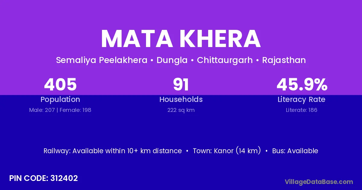
Mata Khera village is located in the Dungla Tehsil of the Chittaurgarh district in Rajasthan .

About Mata Khera Village

Block / Tehsil → Dungla

District → Chittaurgarh

State → Rajasthan

According to Census 2011 information, the village code of Mata Khera village is 312402.

Mata Khera village has a total population of 405 people, of which 207 are males and 198 are females.

The literacy rate of Mata Khera village is 45.93%. Male literacy stands at 63.29% and female literacy at 27.78%.

There are approximately 91 households in Mata Khera village.

Kanor (14 km) is the nearest town to Mata Khera village for major economic activities and is located approximately 14 km away.

Population of Mata Khera Village

The population of Mata Khera village is distributed between literate and illiterate residents as follows:

Population distribution of Mata Khera village by literacy and gender
Particulars Male Female Total
Literate 131 55 186
Illiterate 76 143 219
Total 207 198 405

Source: Census 2011

Nearby Villages

List of nearby villages around Mata Khera village
Village District
Ala Kheri Chittaurgarh
Alod Narsimhapur
Alod Bundi
Alod Chittaurgarh
Alod Kota
Anandpura Aurangabad
Anandpura Nawada
Anandpura Ahmadabad
Anandpura Ahmadabad
Anandpura Banas Kantha
Anandpura Mahesana
Anandpura Mahesana
Anandpura Vadodara
Anandpura Neemuch
Anandpura Rajgarh
Anandpura Banswara
Anandpura Baran
Anandpura Bikaner
Anandpura Chittaurgarh
Anandpura Dausa
Anandpura Dausa
Anandpura Jaipur
Anandpura Jhalawar
Anandpura Jhalawar
Anandpura Jhalawar
Anandpura Jhunjhunun
Anandpura Jodhpur
Anandpura Nagaur
Anandpura Udaipur
Arthala Chittaurgarh
Doongla Chittaurgarh
Fateh Chikarda Chittaurgarh
Karsana Panch Mahals
Karsana Chittaurgarh
Karsana Kanshiram Nagar
Khera Aheeran Chittaurgarh
Pirana Chittaurgarh
Semaliya Peela Khera Chittaurgarh
Talau Neemuch
Talau Chittaurgarh
Talau Lalitpur

Frequently Asked Questions

Mata Khera village is located in the Dungla Tehsil of the Chittaurgarh district in Rajasthan.
The total population is 405 people.
207 males and 198 females.
The literacy rate is 45.93%.
Male literacy rate is 63.29%, and female literacy rate is 27.78%.
There are approximately 91 houses in Mata Khera village.
Kanor (14 km) is the nearest town, located approximately 14 km away.

Reviews and Ratings

0.0 / 5 (0 reviews)

Reviews

No reviews yet. Be the first to review this village!

Mata Khera Village Statistics

Population
405
Area
222 km²
Households
91
Nearest Town :
Kanor (14 km)

Quick Information

State / UT : Rajasthan
Pincode : 312402
Total Area : 222 km²
Population : 405
Households : 91
Gram Panchayat : Semaliya Peelakhera
Nearest Town : Kanor (14 km)

Connectivity of Mata Khera

🚂 Railway Station

Available within 10+ km distance

🚌 Public Bus Service

Available within village

🚌 Private Bus Service

Available within <5 km distance

Need Help?

Contact local tourism office for assistance