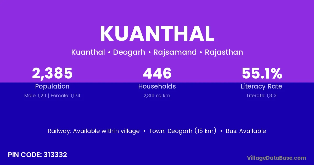
Kuanthal village is located in the Deogarh Tehsil of the Rajsamand district in Rajasthan .
Block / Tehsil → Deogarh
District → Rajsamand
State → Rajasthan
According to Census 2011 information, the village code of Kuanthal village is 313332.
Kuanthal village has a total population of 2,385 people, of which 1,211 are males and 1,174 are females.
The literacy rate of Kuanthal village is 55.05%. Male literacy stands at 67.05% and female literacy at 42.67%.
There are approximately 446 households in Kuanthal village.
Deogarh (15 km) is the nearest town to Kuanthal village for major economic activities and is located approximately 15 km away.
The population of Kuanthal village is distributed between literate and illiterate residents as follows:
| Particulars | Male | Female | Total |
|---|---|---|---|
| Literate | 812 | 501 | 1,313 |
| Illiterate | 399 | 673 | 1,072 |
| Total | 1,211 | 1,174 | 2,385 |
Source: Census 2011
| Village | District |
|---|---|
| Beeyana | Rajsamand |
| Darada | Chamba |
| Darada | Baleshwar |
| Darada | Jagatsinghapur |
| Darada | Kandhamal |
| Darada | Khordha |
| Darada | Rajsamand |
| Halela | Chamba |
| Halela | Rajsamand |
| Jawarji Ka Khera | Rajsamand |
| Kerpura | Chittaurgarh |
| Kerpura | Nagaur |
| Kerpura | Nagaur |
| Kerpura | Rajsamand |
| Kerpura | Sikar |
| Kerpura | Sikar |
| Kerpura | Udaipur |
| Kerpura | Udaipur |
| Kerpura | Udaipur |
| Malaji Ka Gurha | Rajsamand |
| Mata Ka Gaon | Rajsamand |
| Panri | Rajsamand |
| Peetha Ka Khera | Rajsamand |
| Ran | Jamnagar |
| Ran | Chamba |
| Ran | Rajsamand |
| Tapalon Ka Khera | Rajsamand |
No reviews yet. Be the first to review this village!
Available within village
Available within village
Available within village