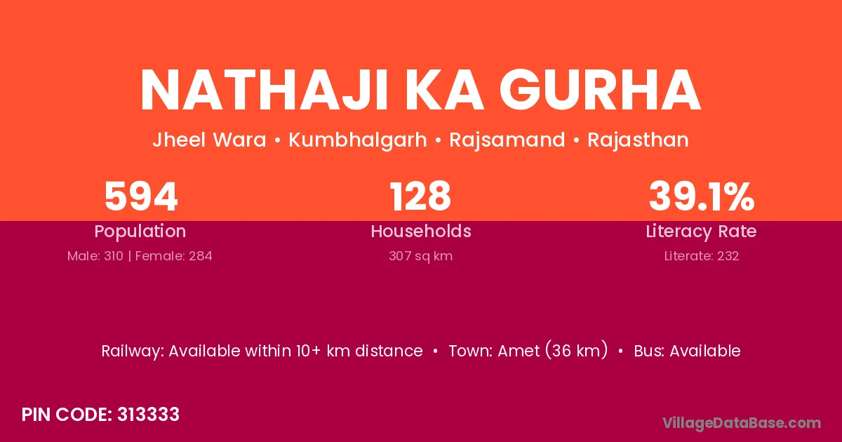
Nathaji Ka Gurha village is located in the Kumbhalgarh Tehsil of the Rajsamand district in Rajasthan .
Block / Tehsil → Kumbhalgarh
District → Rajsamand
State → Rajasthan
According to Census 2011 information, the village code of Nathaji Ka Gurha village is 313333.
Nathaji Ka Gurha village has a total population of 594 people, of which 310 are males and 284 are females.
The literacy rate of Nathaji Ka Gurha village is 39.06%. Male literacy stands at 46.45% and female literacy at 30.99%.
There are approximately 128 households in Nathaji Ka Gurha village.
Amet (36 km) is the nearest town to Nathaji Ka Gurha village for major economic activities and is located approximately 36 km away.
The population of Nathaji Ka Gurha village is distributed between literate and illiterate residents as follows:
| Particulars | Male | Female | Total |
|---|---|---|---|
| Literate | 144 | 88 | 232 |
| Illiterate | 166 | 196 | 362 |
| Total | 310 | 284 | 594 |
Source: Census 2011
| Village | District |
|---|---|
| Beera Ki Bhagal | Rajsamand |
| Chadana Ki Bhagal | Rajsamand |
| Chadana Ki Bhagal | Udaipur |
| Chechiyon Ka Gurha | Rajsamand |
| Dhola Ki Or | Rajsamand |
| Gawar | Hisar |
| Gawar | Mandi |
| Gawar | Jammu |
| Gawar | Yavatmal |
| Gawar | Pali |
| Gawar | Rajsamand |
| Gawar | Chamoli |
| Gawar | Garhwal |
| Kardon Ka Gurha | Rajsamand |
| Majhera | Kangra |
| Majhera | Guna |
| Majhera | Sagar |
| Majhera | Sagar |
| Majhera | Shivpuri |
| Majhera | Vidisha |
| Majhera | Baran |
| Majhera | Rajsamand |
| Majhera | Bageshwar |
| Majhera | Champawat |
| Majhera | Champawat |
| Majhera | Nainital |
| Majhera | Nainital |
| Majhera | Nainital |
| Majhera | Pithoragarh |
| Mewariya | Ajmer |
| Mewariya | Rajsamand |
| Morana | Jamnagar |
| Morana | Porbandar |
| Morana | Kota |
| Morana | Rajsamand |
| Qila Kumbhalgarh | Rajsamand |
| Thurawar | Rajsamand |
No reviews yet. Be the first to review this village!
Available within 10+ km distance
Available within <5 km distance
Available within <5 km distance