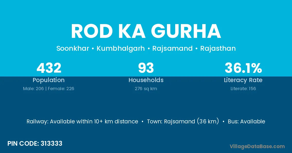
Rod Ka Gurha village is located in the Kumbhalgarh Tehsil of the Rajsamand district in Rajasthan .
Block / Tehsil → Kumbhalgarh
District → Rajsamand
State → Rajasthan
According to Census 2011 information, the village code of Rod Ka Gurha village is 313333.
Rod Ka Gurha village has a total population of 432 people, of which 206 are males and 226 are females.
The literacy rate of Rod Ka Gurha village is 36.11%. Male literacy stands at 48.54% and female literacy at 24.78%.
There are approximately 93 households in Rod Ka Gurha village.
Rajsamand (36 km) is the nearest town to Rod Ka Gurha village for major economic activities and is located approximately 36 km away.
The population of Rod Ka Gurha village is distributed between literate and illiterate residents as follows:
| Particulars | Male | Female | Total |
|---|---|---|---|
| Literate | 100 | 56 | 156 |
| Illiterate | 106 | 170 | 276 |
| Total | 206 | 226 | 432 |
Source: Census 2011
| Village | District |
|---|---|
| Antaliya | Amreli |
| Antaliya | Navsari |
| Antaliya | Rajsamand |
| Antaliya | Udaipur |
| Chadana Ki Bhagal | Rajsamand |
| Chadana Ki Bhagal | Udaipur |
| Chechiyon Ka Gurha | Rajsamand |
| Joor | Surguja |
| Joor | Shivpuri |
| Joor | Rajsamand |
| Kardon Ka Gurha | Rajsamand |
| Mewariya | Ajmer |
| Mewariya | Rajsamand |
| Morana | Jamnagar |
| Morana | Porbandar |
| Morana | Kota |
| Morana | Rajsamand |
| Nathaji Ka Gurha | Rajsamand |
| Ovri Ka Valra | Rajsamand |
| Rati Talai | Dhar |
| Rati Talai | Banswara |
| Rati Talai | Chittaurgarh |
| Rati Talai | Jhalawar |
| Rati Talai | Rajsamand |
| Soonkhar | Rajsamand |
No reviews yet. Be the first to review this village!
Available within 10+ km distance
Available within 5 - 10 km distance
Available within 5 - 10 km distance