Namchi: A Town and Subdivision in South District district
District → South District
State → Sikkim
Namchi is a town and Subdivision in the South District district of the Sikkim. In India, a Subdivision is a subdivision of a district responsible for the administration and revenue collection of a specific area within the district. Subdivisions play a crucial role in the local governance structure, contributing significantly to the development and administration of their communities.
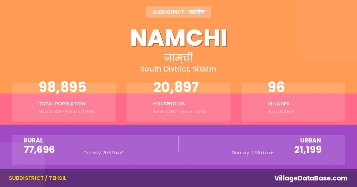
According to the 2011 census The total area of Namchi Subdivision is 298 km², with a population of 98895 people. The population density is 332 inhabitants per square kilometre, and there are approximately 20897 houses in the sub district.
Namchi Subdivision comprises about 96 villages. Below is a list of these villages along with information about their respective gram panchayats and the nearest town:
| # | Village Name | Gram Panchayat | Nearest Town |
|---|---|---|---|
| 1 | Aifaltar | Temi | Namchi (26 km) |
| 2 | Assangthang | Assangthang | Namchi (5 km) |
| 3 | Barnyak | Barnayak Tokal | Singtam (16 km) |
| 4 | Bikmat | Tangzi Bikmat | Namchi (15 km) |
| 5 | Bomtar | Mikkhola Boomtar | Namchi (2 km) |
| 6 | Bul | Rong Bul | Namchi (7 km) |
| 7 | Burul | Rameng Nizrameng | Singtam (26 km) |
| 8 | Chemchey | Damthang | Namchi (18 km) |
| 9 | Chisopani | Tinik Chisopani | Jorethang (6 km) |
| 10 | Chuba | Chuba Phong | Namchi (20 km) |
| 11 | Chumlok | Wok Omchu | Jorethang (14 km) |
| 12 | Damthang | Damthang | Namchi (13 km) |
| 13 | Denchung | Poklok Denchung | Namchi (10 km) |
| 14 | Dhargaon | Salghari | Namchi (9 km) |
| 15 | Donok | Turung Mamring | Rangpo (10 km) |
| 16 | Doring | Namphing | Singtam (9 km) |
| 17 | Dorop | Salghari | Namchi (8 km) |
| 18 | Gangchung | Temi | Namchi (19 km) |
| 19 | Gom | Sorok Shyampani | Namchi (12 km) |
| 20 | Jaubari | Damthang | Namchi (8 km) |
| 21 | Jorethang Forest Block | Tinik Chisopani | Jorethang |
| 22 | Kabrey | Nagi Karek | Rangpo (24 km) |
| 23 | Kamarey | Lungchok Kamarey | Jorethang (15 km) |
| 24 | Kamrang | Mamley Kamrang | Namchi (8 km) |
| 25 | Kanamtek | Namthang Maneydara | Rangpo (17 km) |
| 26 | Karek | Nagi Karek | Namchi (32 km) |
| 27 | Kartickey | Sumbuk Kartikey | Jorethang (13 km) |
| 28 | Kateng Bokrang | Kateng Pamphok | Namchi (34 km) |
| 29 | Kerabari | Mellidara Paiyong | Namchi (26 km) |
| 30 | Kitam | Kitam Manpur | Namchi (15 km) |
| 31 | Kopchey | Mikkhola Boomtar | Namchi (1 km) |
| 32 | Longchok | Lungchok Kamarey | Namchi (17 km) |
| 33 | Majhitar Forest Block | West Pendam | Jorethang (8 km) |
| 34 | Mamley | Mamley Kamrang | Namchi (5 km) |
| 35 | Mamring | Turung Mamring | Rangpo (2 km) |
| 36 | Mamring Forest Block | Turung Mamring | Rangpo (7 km) |
| 37 | Maneydara | Namthang Maneydara | Rangpo (20 km) |
| 38 | Maniram | Maniram Phalidara | Namchi (13 km) |
| 39 | Manpur | Kitam Manpur | Namchi (16 km) |
| 40 | Melli | Mellidara Paiyong | Rangpo (18 km) |
| 41 | Melli Forest Block | Mellidara Paiyong | Namchi (30 km) |
| 42 | Mellidara | Mellidara Paiyong | Rangpo (28 km) |
| 43 | Mikkhola | Mikkhola Boomtar | Namchi (5 km) |
| 44 | Nagi | Nagi Karek | Namchi (20 km) |
| 45 | Nalam Kolbong | Namthang Maneydara | Rangpo (16 km) |
| 46 | Namchi Forest Block | Mamley Kamrang | Namchi (10 km) |
| 47 | Namphing | Namphing | Singtam (6 km) |
| 48 | Namthang Forest Block | Namthang Maneydara | Namchi (15 km) |
| 49 | Nijarmeng | Rameng Nizrameng | Singtam (30 km) |
| 50 | Omchu | Wok Omchu | Jorethang (17 km) |
| 51 | Pabong | Tingrithang | Namchi (12 km) |
| 52 | Paiyong | Mellidara Paiyong | Rangpo (26 km) |
| 53 | Pajer | Tingrithang | Namchi (18 km) |
| 54 | Paleytam | Namthang Maneydara | Rangpo (22 km) |
| 55 | Palum | Rong Bul | Namchi (11 km) |
| 56 | Pamphok | Kateng Pamphok | Rangpo (22 km) |
| 57 | Panchgharey | Turuk Ramabung | Namchi (25 km) |
| 58 | Parbing | Perbing Dovan | Namchi (14 km) |
| 59 | Passi | Rateypani | Namchi (30 km) |
| 60 | Phalidara | Maniram Phalidara | Namchi (8 km) |
| 61 | Phong | Chuba Phong | Namchi (20 km) |
| 62 | Poklok | Poklok Denchung | Namchi (11 km) |
| 63 | Rabikhola | Tangzi Bikmat | Namchi (14 km) |
| 64 | Rabitar | Sadam Suntoley | Namchi (14 km) |
| 65 | Ramabong | Turuk Ramabung | Namchi (24 km) |
| 66 | Rameng | Rameng Nizrameng | Namchi (30 km) |
| 67 | Rashyap | Namphing | Singtam (7 km) |
| 68 | Rateypani | Rateypani | Namchi (17 km) |
| 69 | Rong | Rong Bul | Namchi (13 km) |
| 70 | Sadam | Sadam Suntoley | Namchi (16 km) |
| 71 | Saleumbong | Mikkhola Boomtar | Namchi (7 km) |
| 72 | Salghari | Salghari | Jorethang (8 km) |
| 73 | Sangbung | Assangthang | Namchi (5 km) |
| 74 | Shyampani | Sorok Shyampani | Namchi (9 km) |
| 75 | Singhithang | Mikkhola Boomtar | Namchi (1 km) |
| 76 | Singtam | Rong Bul | Namchi (8 km) |
| 77 | Sorok | Sorok Shyampani | Namchi (7 km) |
| 78 | Sukrabarey | Sadam Suntoley | Namchi (17 km) |
| 79 | Sumbuk | Sumbuk Kartikey | Namchi (16 km) |
| 80 | Suntaley | Sumbuk Kartikey | Namchi (16 km) |
| 81 | Tanak | Tarku | Singtam (16 km) |
| 82 | Tangji | Tangzi Bikmat | Namchi (20 km) |
| 83 | Tarku | Tarku | Singtam (20 km) |
| 84 | Temi | Temi | Singtam (25 km) |
| 85 | Temi Forest Block | Temi | Namchi (20 km) |
| 86 | Temi Tea Estate | Temi | Namchi (20 km) |
| 87 | Thangsing | Barnayak Tokal | Singtam (18 km) |
| 88 | Tingrithang | Tingrithang | Namchi (5 km) |
| 89 | Tinik | Tinik Chisopani | Jorethang (5 km) |
| 90 | Tinzer | Mamley Kamrang | Namchi (1 km) |
| 91 | Tokal | Barnayak Tokal | Singtam (13 km) |
| 92 | Tokdey | Barnayak Tokal | Singtam (9 km) |
| 93 | Tsalumthang | Chalamthang Pacheykhani | Singtam (10 km) |
| 94 | Turuk | Turuk Ramabung | Namchi (22 km) |
| 95 | Turung | Turung Mamring | Rangpo (15 km) |
| 96 | Wak | Wok Omchu | Namchi (17 km) |
The population is distributed between urban and rural areas as follows:
| Particulars | Rural | Urban | Total |
|---|---|---|---|
| Total Population | 77696 | 21199 | 98895 |
| Male Population | 40517 | 10822 | 51339 |
| Female Population | 37179 | 10377 | 47556 | Population Density | 268 / km² | 2789 / km² | 332 / km² |
The distribution of households in the Namchi is:
| Rural Households | Urban Households | Total Households |
|---|---|---|
| 16057 | 4840 | 20897 |
Q: What is Namchi?
A: Namchi is a town and in the South District district of the Sikkim.
Q: What is the total area of Namchi Subdivision?
A: The total area of Namchi Subdivision is 298 km².
Q: What is the population of Namchi Subdivision according to the 2011 census?
A: According to the 2011 census, the population of Namchi Subdivision is 98895.
Q: What is the population density of Namchi Subdivision?
A: The population density of Namchi Subdivision is 332 inhabitants per square kilometre.
Q: How many houses are there in Namchi Subdivision?
A: There are approximately 20897 houses in Namchi Subdivision.
Q: How many villages are there in Namchi Subdivision?
A: There are about 96 villages in Namchi Subdivision.
Q: Which is the largest village by population in Namchi Subdivision?
A: The largest village by population in Namchi Subdivision is Melli, with 2602 people.
Q: Which is the smallest village by population in Namchi Subdivision?
A: The smallest village by population in Namchi Subdivision is Jorethang Forest Block, with 0 people.
Q: Which is the largest village by area in Namchi Subdivision?
A: The largest village by area in Namchi Subdivision is Namchi Forest Block, with 12405 km².
Q: Which is the smallest village by area in Namchi Subdivision?
A: The smallest village by area in Namchi Subdivision is Temi Tea Estate, with 0 km².
Q: What is the male population of Namchi Subdivision?
A: The male population of Namchi Subdivision is 51339.
Q: What is the female population of Namchi Subdivision?
A: The female population of Namchi Subdivision is 47556.
Q: How many villages in Namchi Subdivision have a population of less than 100?
A: There are 6 villages in Namchi Subdivision with a population of less than 100.
Q: How many villages in Namchi Subdivision have a population between 100 and 499?
A: There are 21 villages in Namchi Subdivision with a population between 100 and 499.
Q: How many villages in Namchi Subdivision have a population between 500 and 999?
A: There are 43 villages in Namchi Subdivision with a population between 500 and 999.
Q: How many villages in Namchi Subdivision have a population between 1000 and 1999?
A: There are 23 villages in Namchi Subdivision with a population between 1000 and 1999.
Q: How many villages in Namchi Subdivision have a population between 2000 and 2999?
A: There is 3 village in Namchi Subdivision with a population between 2000 and 2999.
| Total Population | Villages in Sub District Of Namchi |
|---|---|
| Less than 100 | 6 |
| 100-499 | 21 |
| 500-999 | 43 |
| 1000-1999 | 23 |
| 2000-2999 | 3 |