Sarangapur: A Town and Mandal in Karimnagar district
District → Karimnagar
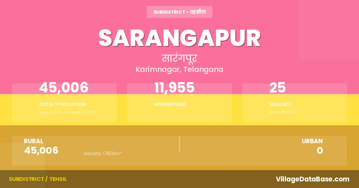
State → Telangana
Sarangapur is a town and Mandal in the Karimnagar district of the Telangana. In India, a Mandal is a subdivision of a district responsible for the administration and revenue collection of a specific area within the district. Mandals play a crucial role in the local governance structure, contributing significantly to the development and administration of their communities.
According to the 2011 census The total area of Sarangapur Mandal is 256 km², with a population of 45006 people. The population density is 176 inhabitants per square kilometre, and there are approximately 11955 houses in the sub district.
Sarangapur Mandal comprises about 25 villages. Below is a list of these villages along with information about their respective gram panchayats and the nearest town:
| # | Village Name | Gram Panchayat | Nearest Town |
|---|---|---|---|
| 1 | Arpapalle | Arpapalle | Jagtial (12 km) |
| 2 | Battapalle | Battapally | Jagtial (22 km) |
| 3 | Beerpur | Beerpur | Jagtial (30 km) |
| 4 | Cherlapalle | Cherlapalle | Jagtial (40 km) |
| 5 | Ganeshpalle | Potharam | Jagtial (19 km) |
| 6 | Kammunur | Kammunoor | Jagtial (38 km) |
| 7 | Kandlapalle | Kandlapalle | Jagtial (38 km) |
| 8 | Kolvai | Kolvai | Jagtial (31 km) |
| 9 | Komanpalle | Kolvai | Jagtial (36 km) |
| 10 | Konapur | Konapur | Jagtial (8 km) |
| 11 | Latchakkapet | Lachakkapet | Jagtial (8 km) |
| 12 | Laxmidevipalle | Laxmidevipally | Jagtial (12 km) |
| 13 | Mangela | Mangela | Jagtial (40 km) |
| 14 | Mothinagar | Thungur | Jagtial (36 km) |
| 15 | Nagunur | Nagunur | Jagtial (9 km) |
| 16 | Narsimlapalle | Narsimlapalle | Jagtial (25 km) |
| 17 | Pembetla | Pembatla | Jagtial (8 km) |
| 18 | Potharam | Potharam | Jagtial (21 km) |
| 19 | Rangapet | Rangapet | Jagtial (12 km) |
| 20 | Rangasagar | Rangasagar | Jagtial (46 km) |
| 21 | Rechapalle | Rechapally | Jagtial (18 km) |
| 22 | Rekulapalle | Rekulapally | Jagtial (35 km) |
| 23 | Sarangapur | Sarangapur | Jagtial (16 km) |
| 24 | Thalladharmaram | Thalladharmaram | Jagtial (36 km) |
| 25 | Thungur | Thungur | Jagtial (28 km) |
The population is distributed between urban and rural areas as follows:
| Particulars | Rural | Urban | Total |
|---|---|---|---|
| Total Population | 45006 | 0 | 45006 |
| Male Population | 21909 | 0 | 21909 |
| Female Population | 23097 | 0 | 23097 | Population Density | 176 / km² | 176 / km² |
The distribution of households in the Sarangapur is:
| Rural Households | Urban Households | Total Households |
|---|---|---|
| 11955 | 0 | 11955 |
Q: What is Sarangapur?
A: Sarangapur is a town and in the Karimnagar district of the Telangana.
Q: What is the total area of Sarangapur Mandal?
A: The total area of Sarangapur Mandal is 256 km².
Q: What is the population of Sarangapur Mandal according to the 2011 census?
A: According to the 2011 census, the population of Sarangapur Mandal is 45006.
Q: What is the population density of Sarangapur Mandal?
A: The population density of Sarangapur Mandal is 176 inhabitants per square kilometre.
Q: How many houses are there in Sarangapur Mandal?
A: There are approximately 11955 houses in Sarangapur Mandal.
Q: How many villages are there in Sarangapur Mandal?
A: There are about 25 villages in Sarangapur Mandal.
Q: Which is the largest village by population in Sarangapur Mandal?
A: The largest village by population in Sarangapur Mandal is Rechapalle, with 5175 people.
Q: Which is the smallest village by population in Sarangapur Mandal?
A: The smallest village by population in Sarangapur Mandal is Ganeshpalle, with 244 people.
Q: Which is the largest village by area in Sarangapur Mandal?
A: The largest village by area in Sarangapur Mandal is Kammunur, with 4590 km².
Q: Which is the smallest village by area in Sarangapur Mandal?
A: The smallest village by area in Sarangapur Mandal is Latchakkapet, with 197 km².
Q: What is the population distribution between urban and rural areas in Sarangapur Mandal?
A: The population distribution in Sarangapur Mandal is entirely rural, with a total rural population of 45006.
Q: What is the male population of Sarangapur Mandal?
A: The male population of Sarangapur Mandal is 21909.
Q: What is the female population of Sarangapur Mandal?
A: The female population of Sarangapur Mandal is 23097.
Q: How is the household distribution in Sarangapur Mandal?
A: The household distribution in Sarangapur Mandal is entirely rural, with a total of 11955 households.
Q: How many villages in Sarangapur Mandal have a population between 100 and 499?
A: There are 3 villages in Sarangapur Mandal with a population between 100 and 499.
Q: How many villages in Sarangapur Mandal have a population between 500 and 999?
A: There are 4 villages in Sarangapur Mandal with a population between 500 and 999.
Q: How many villages in Sarangapur Mandal have a population between 1000 and 1999?
A: There are 9 villages in Sarangapur Mandal with a population between 1000 and 1999.
Q: How many villages in Sarangapur Mandal have a population between 2000 and 2999?
A: There is 6 village in Sarangapur Mandal with a population between 2000 and 2999.
Q: How many villages in Sarangapur Mandal have a population between 3000 and 3999?
A: There is 2 village in Sarangapur Mandal with a population between 3000 and 3999.
Q: How many villages in Sarangapur Mandal have a population of 5000 and above?
A: There is 1 village in Sarangapur Mandal with a population of 5000 and above.
| Total Population | Villages in Sub District Of Sarangapur |
|---|---|
| 100-499 | 3 |
| 500-999 | 4 |
| 1000-1999 | 9 |
| 2000-2999 | 6 |
| 3000-3999 | 2 |
| 5000 And Above | 1 |