Munagala: A Town and Mandal in Nalgonda district
District → Nalgonda
State → Telangana
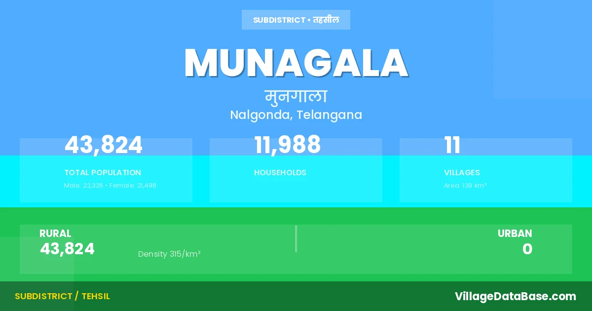
Munagala is a town and Mandal in the Nalgonda district of the Telangana. In India, a Mandal is a subdivision of a district responsible for the administration and revenue collection of a specific area within the district. Mandals play a crucial role in the local governance structure, contributing significantly to the development and administration of their communities.
According to the 2011 census The total area of Munagala Mandal is 139 km², with a population of 43824 people. The population density is 315 inhabitants per square kilometre, and there are approximately 11988 houses in the sub district.
Munagala Mandal comprises about 11 villages. Below is a list of these villages along with information about their respective gram panchayats and the nearest town:
| # | Village Name | Gram Panchayat | Nearest Town |
|---|---|---|---|
| 1 | Akupamula | Akupamula | Suryapet (38 km) |
| 2 | Barakatha Guda | Bharakatgudem | Suryapet (33 km) |
| 3 | Ganapavaram | Ganapavaram | Suryapet (28 km) |
| 4 | Kalakova | Kalakova | Suryapet (30 km) |
| 5 | Kokkireni | Kokkireni | Suryapet (26 km) |
| 6 | Madhavaram | Madharam | Suryapet (32 km) |
| 7 | Munagala | Munagala | Suryapet (30 km) |
| 8 | Nelamarri | Nelamarry | Suryapet (26 km) |
| 9 | Repala | Repala | Suryapet (35 km) |
| 10 | Syedmujavarpet | Munagala | Suryapet (30 km) |
| 11 | Tadvai | Tadvai | Suryapet (28 km) |
The population is distributed between urban and rural areas as follows:
| Particulars | Rural | Urban | Total |
|---|---|---|---|
| Total Population | 43824 | 0 | 43824 |
| Male Population | 22326 | 0 | 22326 |
| Female Population | 21498 | 0 | 21498 | Population Density | 315 / km² | 315 / km² |
The distribution of households in the Munagala is:
| Rural Households | Urban Households | Total Households |
|---|---|---|
| 11988 | 0 | 11988 |
Q: What is Munagala?
A: Munagala is a town and in the Nalgonda district of the Telangana.
Q: What is the total area of Munagala Mandal?
A: The total area of Munagala Mandal is 139 km².
Q: What is the population of Munagala Mandal according to the 2011 census?
A: According to the 2011 census, the population of Munagala Mandal is 43824.
Q: What is the population density of Munagala Mandal?
A: The population density of Munagala Mandal is 315 inhabitants per square kilometre.
Q: How many houses are there in Munagala Mandal?
A: There are approximately 11988 houses in Munagala Mandal.
Q: How many villages are there in Munagala Mandal?
A: There are about 11 villages in Munagala Mandal.
Q: Which is the largest village by population in Munagala Mandal?
A: The largest village by population in Munagala Mandal is Munagala, with 8942 people.
Q: Which is the smallest village by population in Munagala Mandal?
A: The smallest village by population in Munagala Mandal is Syedmujavarpet, with 720 people.
Q: Which is the largest village by area in Munagala Mandal?
A: The largest village by area in Munagala Mandal is Repala, with 3905 km².
Q: Which is the smallest village by area in Munagala Mandal?
A: The smallest village by area in Munagala Mandal is Ganapavaram, with 567 km².
Q: What is the population distribution between urban and rural areas in Munagala Mandal?
A: The population distribution in Munagala Mandal is entirely rural, with a total rural population of 43824.
Q: What is the male population of Munagala Mandal?
A: The male population of Munagala Mandal is 22326.
Q: What is the female population of Munagala Mandal?
A: The female population of Munagala Mandal is 21498.
Q: How is the household distribution in Munagala Mandal?
A: The household distribution in Munagala Mandal is entirely rural, with a total of 11988 households.
Q: How many villages in Munagala Mandal have a population between 500 and 999?
A: There are 1 villages in Munagala Mandal with a population between 500 and 999.
Q: How many villages in Munagala Mandal have a population between 1000 and 1999?
A: There are 2 villages in Munagala Mandal with a population between 1000 and 1999.
Q: How many villages in Munagala Mandal have a population between 2000 and 2999?
A: There is 2 village in Munagala Mandal with a population between 2000 and 2999.
Q: How many villages in Munagala Mandal have a population between 3000 and 3999?
A: There is 2 village in Munagala Mandal with a population between 3000 and 3999.
Q: How many villages in Munagala Mandal have a population between 4000 and 4999?
A: There is 1 village in Munagala Mandal with a population between 4000 and 4999.
Q: How many villages in Munagala Mandal have a population of 5000 and above?
A: There is 3 village in Munagala Mandal with a population of 5000 and above.
| Total Population | Villages in Sub District Of Munagala |
|---|---|
| 500-999 | 1 |
| 1000-1999 | 2 |
| 2000-2999 | 2 |
| 3000-3999 | 2 |
| 4000-4999 | 1 |
| 5000 And Above | 3 |