Vemulapalle: A Town and Mandal in Nalgonda district
District → Nalgonda
State → Telangana
Vemulapalle is a town and Mandal in the Nalgonda district of the Telangana. In India, a Mandal is a subdivision of a district responsible for the administration and revenue collection of a specific area within the district. Mandals play a crucial role in the local governance structure, contributing significantly to the development and administration of their communities.
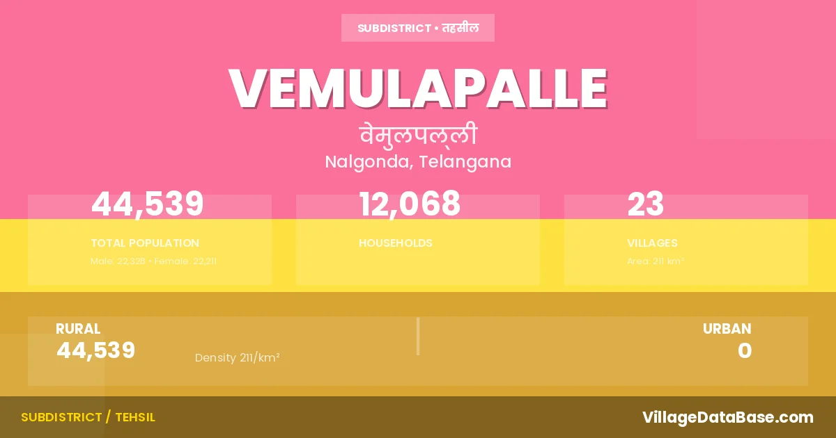
According to the 2011 census The total area of Vemulapalle Mandal is 211 km², with a population of 44539 people. The population density is 211 inhabitants per square kilometre, and there are approximately 12068 houses in the sub district.
Vemulapalle Mandal comprises about 23 villages. Below is a list of these villages along with information about their respective gram panchayats and the nearest town:
| # | Village Name | Gram Panchayat | Nearest Town |
|---|---|---|---|
| 1 | Agamothkur | Agamothkur | Suryapet (25 km) |
| 2 | Amangal | Amangal | Suryapet (15 km) |
| 3 | Annapareddiguda | Annapureddy Gudem | Miryalaguda (6 km) |
| 4 | Bheeman Palle | Bheemana Pally | Suryapet (20 km) |
| 5 | Bommakal | Bommakal | Suryapet (28 km) |
| 6 | Buggabavi Guda | Vemulapally | Miryalaguda (11 km) |
| 7 | Chali Chimala Palem | Vemulapally | Suryapet (20 km) |
| 8 | Chirumarthy | Chirumarthy | Suryapet (20 km) |
| 9 | Gandravaniguda | Vemulapally | Miryalaguda (17 km) |
| 10 | Itikyala | Vemulapally | Miryalaguda (8 km) |
| 11 | Kalvalapalem | Kalvala Palem | Suryapet (15 km) |
| 12 | Kamepalle | Kamepally | Miryalaguda (20 km) |
| 13 | Koyalpahad | Vemulapally | Suryapet (28 km) |
| 14 | Kukkadam | Kukkadam | Miryalaguda (13 km) |
| 15 | Molka Patnam | Molkapatnam | Miryalaguda (14 km) |
| 16 | Mundlapahad | Vemulapally | Miryalaguda (8 km) |
| 17 | Pamulapahad | Pamula Pahad | Suryapet (15 km) |
| 18 | Ravula Penta | Ravulapenta | Suryapet (23 km) |
| 19 | Salkunur | Salkunoor | Suryapet (19 km) |
| 20 | Settipalem | Shetti Palem | Miryalaguda (6 km) |
| 21 | Thimmareddiguda | Thimmareddy Gudem | Miryalaguda (10 km) |
| 22 | Thopucherla | Thopucharla | Miryalaguda (20 km) |
| 23 | Vemulapalle | Vemulapally | Miryalaguda (5 km) |
The population is distributed between urban and rural areas as follows:
| Particulars | Rural | Urban | Total |
|---|---|---|---|
| Total Population | 44539 | 0 | 44539 |
| Male Population | 22328 | 0 | 22328 |
| Female Population | 22211 | 0 | 22211 | Population Density | 211 / km² | 211 / km² |
The distribution of households in the Vemulapalle is:
| Rural Households | Urban Households | Total Households |
|---|---|---|
| 12068 | 0 | 12068 |
Q: What is Vemulapalle?
A: Vemulapalle is a town and in the Nalgonda district of the Telangana.
Q: What is the total area of Vemulapalle Mandal?
A: The total area of Vemulapalle Mandal is 211 km².
Q: What is the population of Vemulapalle Mandal according to the 2011 census?
A: According to the 2011 census, the population of Vemulapalle Mandal is 44539.
Q: What is the population density of Vemulapalle Mandal?
A: The population density of Vemulapalle Mandal is 211 inhabitants per square kilometre.
Q: How many houses are there in Vemulapalle Mandal?
A: There are approximately 12068 houses in Vemulapalle Mandal.
Q: How many villages are there in Vemulapalle Mandal?
A: There are about 23 villages in Vemulapalle Mandal.
Q: Which is the largest village by population in Vemulapalle Mandal?
A: The largest village by population in Vemulapalle Mandal is Vemulapalle, with 4646 people.
Q: Which is the smallest village by population in Vemulapalle Mandal?
A: The smallest village by population in Vemulapalle Mandal is Mundlapahad, with 19 people.
Q: Which is the largest village by area in Vemulapalle Mandal?
A: The largest village by area in Vemulapalle Mandal is Thopucherla, with 2524 km².
Q: Which is the smallest village by area in Vemulapalle Mandal?
A: The smallest village by area in Vemulapalle Mandal is Chali Chimala Palem, with 272 km².
Q: What is the population distribution between urban and rural areas in Vemulapalle Mandal?
A: The population distribution in Vemulapalle Mandal is entirely rural, with a total rural population of 44539.
Q: What is the male population of Vemulapalle Mandal?
A: The male population of Vemulapalle Mandal is 22328.
Q: What is the female population of Vemulapalle Mandal?
A: The female population of Vemulapalle Mandal is 22211.
Q: How is the household distribution in Vemulapalle Mandal?
A: The household distribution in Vemulapalle Mandal is entirely rural, with a total of 12068 households.
Q: How many villages in Vemulapalle Mandal have a population of less than 100?
A: There are 1 villages in Vemulapalle Mandal with a population of less than 100.
Q: How many villages in Vemulapalle Mandal have a population between 100 and 499?
A: There are 1 villages in Vemulapalle Mandal with a population between 100 and 499.
Q: How many villages in Vemulapalle Mandal have a population between 500 and 999?
A: There are 5 villages in Vemulapalle Mandal with a population between 500 and 999.
Q: How many villages in Vemulapalle Mandal have a population between 1000 and 1999?
A: There are 5 villages in Vemulapalle Mandal with a population between 1000 and 1999.
Q: How many villages in Vemulapalle Mandal have a population between 2000 and 2999?
A: There is 6 village in Vemulapalle Mandal with a population between 2000 and 2999.
Q: How many villages in Vemulapalle Mandal have a population between 3000 and 3999?
A: There is 3 village in Vemulapalle Mandal with a population between 3000 and 3999.
Q: How many villages in Vemulapalle Mandal have a population between 4000 and 4999?
A: There is 2 village in Vemulapalle Mandal with a population between 4000 and 4999.
| Total Population | Villages in Sub District Of Vemulapalle |
|---|---|
| Less than 100 | 1 |
| 100-499 | 1 |
| 500-999 | 5 |
| 1000-1999 | 5 |
| 2000-2999 | 6 |
| 3000-3999 | 3 |
| 4000-4999 | 2 |