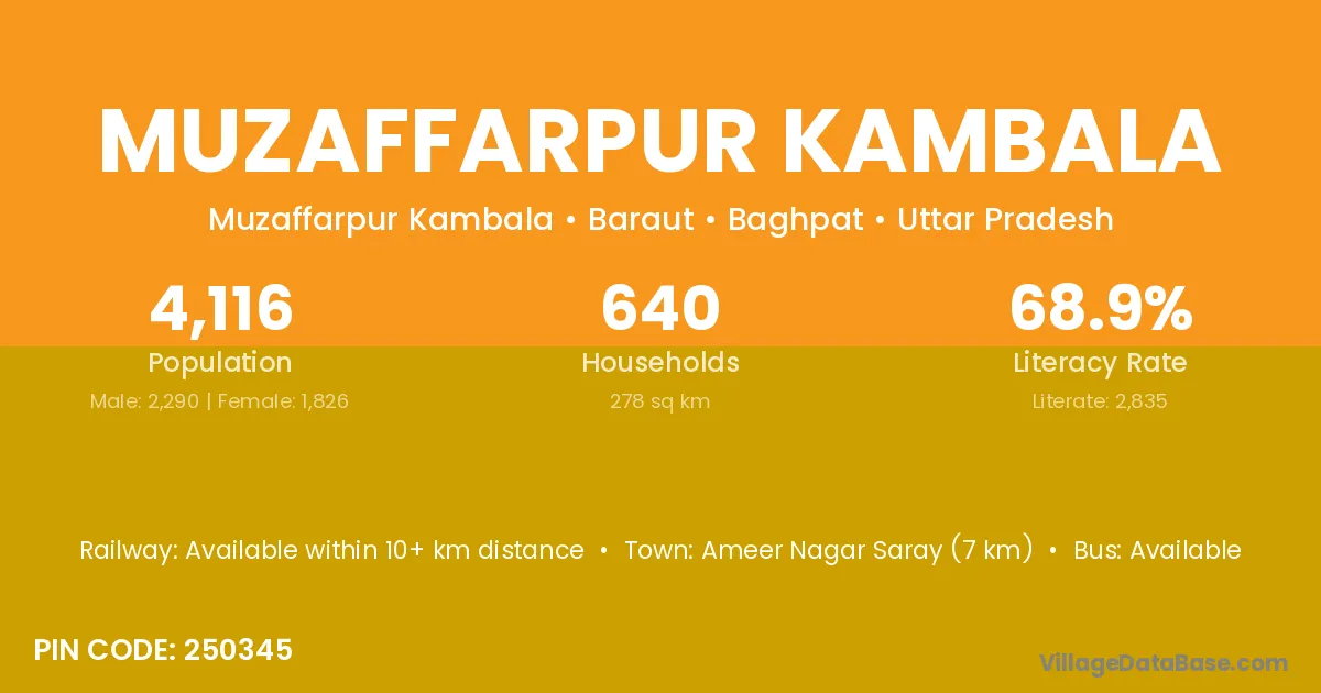
Muzaffarpur Kambala village is located in the Baraut Tehsil of the Baghpat district in Uttar Pradesh .
Block / Tehsil → Baraut
District → Baghpat
State → Uttar Pradesh
According to Census 2011 information, the village code of Muzaffarpur Kambala village is 250345.
Muzaffarpur Kambala village has a total population of 4,116 people, of which 2,290 are males and 1,826 are females.
The literacy rate of Muzaffarpur Kambala village is 68.88%. Male literacy stands at 76.59% and female literacy at 59.20%.
There are approximately 640 households in Muzaffarpur Kambala village.
Ameer Nagar Saray (7 km) is the nearest town to Muzaffarpur Kambala village for major economic activities and is located approximately 7 km away.
The population of Muzaffarpur Kambala village is distributed between literate and illiterate residents as follows:
| Particulars | Male | Female | Total |
|---|---|---|---|
| Literate | 1,754 | 1,081 | 2,835 |
| Illiterate | 536 | 745 | 1,281 |
| Total | 2,290 | 1,826 | 4,116 |
Source: Census 2011
| Village | District |
|---|---|
| Ahamadabad Garhi | Baghpat |
| Galheta | Baghpat |
| Hazurabad Garhi | Baghpat |
| Ibrahima Bad Gawri | Baghpat |
| Jainuddinpur Chirchiya | Baghpat |
| Kherae Islampur | Baghpat |
| Mawi Kalan | Baghpat |
| Muzaffarpur Poes | Baghpat |
| Rajpur Khampur | Baghpat |
| Sanjarpur Kaidwa | Baghpat |
| Tera | Kachchh |
| Tera | Baghpat |
| Tera | Banda |
| Tera | Bara Banki |
| Tera | Bareilly |
| Tera | Farrukhabad |
| Tera | Hardoi |
| Tera | Kanpur Dehat |
| Tera | Lalitpur |
| Tera | Shahjahanpur |
| Tera | Uttarkashi |
No reviews yet. Be the first to review this village!
Available within 10+ km distance
Available within <5 km distance
Available within 10+ km distance