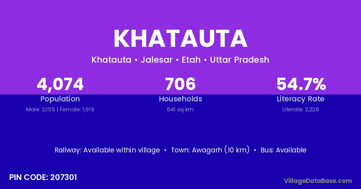
Khatauta village is located in the Jalesar Tehsil of the Etah district in Uttar Pradesh .
Block / Tehsil → Jalesar
District → Etah
State → Uttar Pradesh
According to Census 2011 information, the village code of Khatauta village is 207301.
Khatauta village has a total population of 4,074 people, of which 2,155 are males and 1,919 are females.
The literacy rate of Khatauta village is 54.69%. Male literacy stands at 63.53% and female literacy at 44.76%.
There are approximately 706 households in Khatauta village.
Awagarh (10 km) is the nearest town to Khatauta village for major economic activities and is located approximately 10 km away.
The population of Khatauta village is distributed between literate and illiterate residents as follows:
| Particulars | Male | Female | Total |
|---|---|---|---|
| Literate | 1,369 | 859 | 2,228 |
| Illiterate | 786 | 1,060 | 1,846 |
| Total | 2,155 | 1,919 | 4,074 |
Source: Census 2011
| Village | District |
|---|---|
| Aunera | Etah |
| Churthara | Etah |
| Hinauna | Etah |
| Jinawali | Gwalior |
| Jinawali | Etah |
| Mahmood Pur Kham | Kanshiram Nagar |
| Mahmood Pur Pukhta | Kanshiram Nagar |
| Mandawali | Chittaurgarh |
| Mandawali | Bijnor |
| Mandawali | Bulandshahr |
| Mandawali | Kanshiram Nagar |
| Mandawali | Hardwar |
| Rohina Mirzapur | Etah |
| Sahnaua | Etah |
| Sarani | Chhatarpur |
| Sarani | Thane |
| Sarani | Dhaulpur |
| Sarani | Ballia |
| Sarani | Etah |
| Tisar | Etah |
No reviews yet. Be the first to review this village!
Available within village
Available within 5 - 10 km distance
Available within 5 - 10 km distance