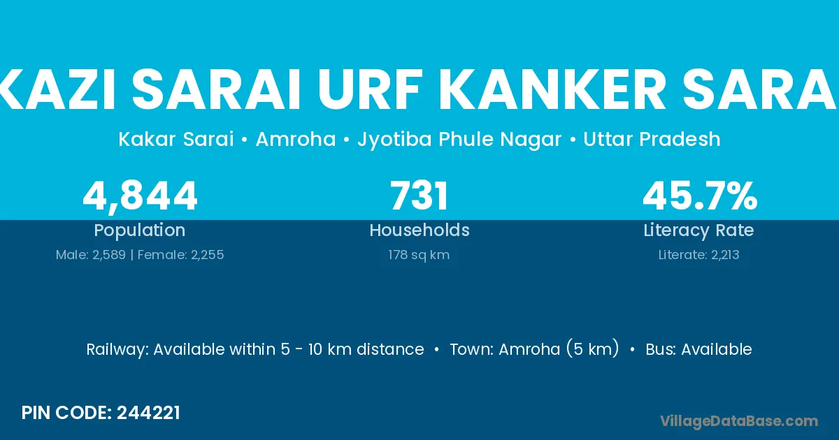
Kazi Sarai Urf Kanker Sarai village is located in the Amroha Tehsil of the Jyotiba Phule Nagar district in Uttar Pradesh .
Block / Tehsil → Amroha
District → Jyotiba Phule Nagar
State → Uttar Pradesh
According to Census 2011 information, the village code of Kazi Sarai Urf Kanker Sarai village is 244221.
Kazi Sarai Urf Kanker Sarai village has a total population of 4,844 people, of which 2,589 are males and 2,255 are females.
The literacy rate of Kazi Sarai Urf Kanker Sarai village is 45.69%. Male literacy stands at 55.43% and female literacy at 34.50%.
There are approximately 731 households in Kazi Sarai Urf Kanker Sarai village.
Amroha (5 km) is the nearest town to Kazi Sarai Urf Kanker Sarai village for major economic activities and is located approximately 5 km away.
The population of Kazi Sarai Urf Kanker Sarai village is distributed between literate and illiterate residents as follows:
| Particulars | Male | Female | Total |
|---|---|---|---|
| Literate | 1,435 | 778 | 2,213 |
| Illiterate | 1,154 | 1,477 | 2,631 |
| Total | 2,589 | 2,255 | 4,844 |
Source: Census 2011
| Village | District |
|---|---|
| Chak Dendera | Jyotiba Phule Nagar |
| Chak Nagli Asdullahpur | Jyotiba Phule Nagar |
| Daidera | Jyotiba Phule Nagar |
| Dhanora Urf Murad Nagar | Jyotiba Phule Nagar |
| Dhela Nagla | Jyotiba Phule Nagar |
| Jagga Nagla | Jyotiba Phule Nagar |
| Majoo Pura | Jyotiba Phule Nagar |
| Muneempur Waispur | Jyotiba Phule Nagar |
| Nagli Asdullahpur | Jyotiba Phule Nagar |
| Saidpur Khalsa | Begusarai |
| Saidpur Khalsa | Jyotiba Phule Nagar |
| Shahzadpur Khurd | Jyotiba Phule Nagar |
No reviews yet. Be the first to review this village!
Available within 5 - 10 km distance
Available within 5 - 10 km distance
Available within 5 - 10 km distance