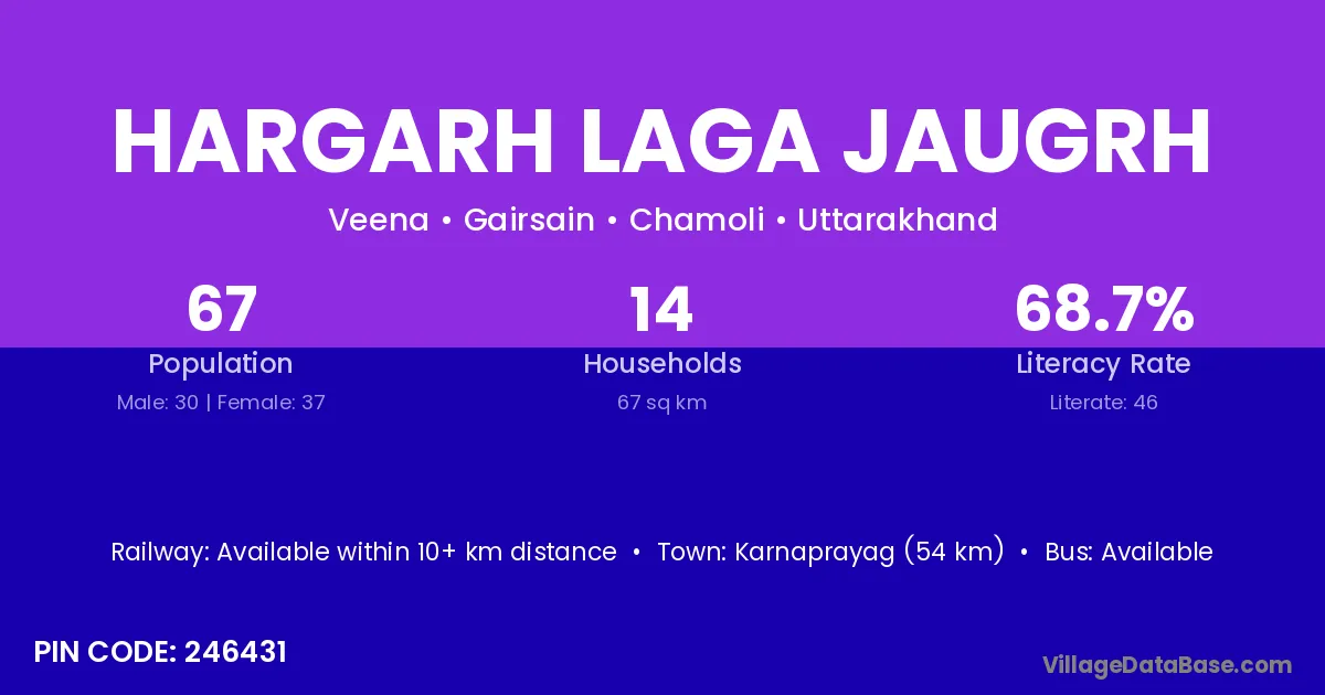
Hargarh Laga Jaugrh village is located in the Gairsain Tehsil of the Chamoli district in Uttarakhand .
Block / Tehsil → Gairsain
District → Chamoli
State → Uttarakhand
According to Census 2011 information, the village code of Hargarh Laga Jaugrh village is 246431.
Hargarh Laga Jaugrh village has a total population of 67 people, of which 30 are males and 37 are females.
The literacy rate of Hargarh Laga Jaugrh village is 68.66%. Male literacy stands at 80.00% and female literacy at 59.46%.
There are approximately 14 households in Hargarh Laga Jaugrh village.
Karnaprayag (54 km) is the nearest town to Hargarh Laga Jaugrh village for major economic activities and is located approximately 54 km away.
The population of Hargarh Laga Jaugrh village is distributed between literate and illiterate residents as follows:
| Particulars | Male | Female | Total |
|---|---|---|---|
| Literate | 24 | 22 | 46 |
| Illiterate | 6 | 15 | 21 |
| Total | 30 | 37 | 67 |
Source: Census 2011
| Village | District |
|---|---|
| Agar Laga Gawali | Chamoli |
| Agar Laga Jinagor | Chamoli |
| Bajyani | Chamoli |
| Bina | Supaul |
| Bina | Mandi |
| Bina | Alirajpur |
| Bina | Nagpur |
| Bina | Chamoli |
| Haragarh | Chamoli |
| Kunakhet | Chamoli |
| Maso Sera | Chamoli |
| Ramara Talla | Chamoli |
| Rohira | Anugul |
| Rohira | Sangrur |
| Rohira | Banswara |
| Rohira | Sirohi |
| Rohira | Chamoli |
| Saner Laga Jingor | Chamoli |
| Wasisem Laga Akshawara | Chamoli |
No reviews yet. Be the first to review this village!
Available within 10+ km distance
Available within 5 - 10 km distance
Available within 10+ km distance