Betalghat: A Town and Tehsil in Nainital district
District → Nainital
State → Uttarakhand
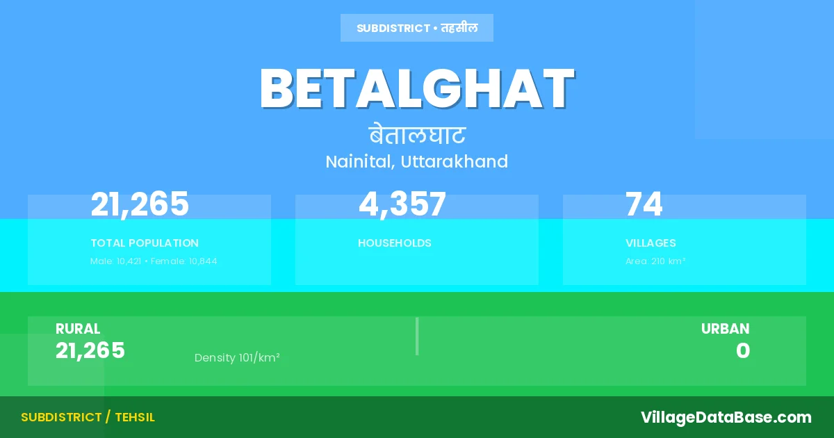
Betalghat is a town and Tehsil in the Nainital district of the Uttarakhand. In India, a Tehsil is a subdivision of a district responsible for the administration and revenue collection of a specific area within the district. Tehsils play a crucial role in the local governance structure, contributing significantly to the development and administration of their communities.
According to the 2011 census The total area of Betalghat Tehsil is 210 km², with a population of 21265 people. The population density is 101 inhabitants per square kilometre, and there are approximately 4357 houses in the sub district.
Betalghat Tehsil comprises about 74 villages. Below is a list of these villages along with information about their respective gram panchayats and the nearest town:
| # | Village Name | Gram Panchayat | Nearest Town |
|---|---|---|---|
| 1 | Aam Ki Sar | Ramnagar (70 km) | |
| 2 | Amel | Amail | Nainital (55 km) |
| 3 | Badhani Gaon | Talla Gaon | Ranikhet (55 km) |
| 4 | Bhatraunj Khan | Bhatroj | Ranikhet (34 km) |
| 5 | Binkote | Binkot | Ranikhet (39 km) |
| 6 | Bishguli | Katmeegajar | Ranikhet (60 km) |
| 7 | Bunga | Khearlibunga | Nainital (59 km) |
| 8 | Chandrakote | Chandra Kot | Ranikhet (35 km) |
| 9 | Chandula | Ghaghareti | Nainital (54 km) |
| 10 | Chauni | Chyuni | Ranikhet (34 km) |
| 11 | Chhapar | Nainital (59 km) | |
| 12 | Chuni Chak Adwari | Chakbaheri | Nainital (51 km) |
| 13 | Dabarbadi | Joshi Khola | Ranikhet (45 km) |
| 14 | Dadima | Darima | Nainital (57 km) |
| 15 | Dandesari | Malli Pali | Ranikhet (50 km) |
| 16 | Dhari | Dhari | Nainital (37 km) |
| 17 | Dholgaon | Dhol Gaon | Ranikhet (40 km) |
| 18 | Digthari | Digthari | Ranikhet (25 km) |
| 19 | Ghaghreti | Ghaghareti | Nainital (64 km) |
| 20 | Ghirauli | Ghiroli | Ranikhet (50 km) |
| 21 | Ghoria Halson | Ghoriya Halso | Ranikhet (50 km) |
| 22 | Haldyani | Haldyani | Ranikhet (43 km) |
| 23 | Halla Lagga Baroseer | Nainital (45 km) | |
| 24 | Halsau | Halso Kord | Nainital (46 km) |
| 25 | Harchnowly | Ghiroli | Ranikhet (50 km) |
| 26 | Hari Nagar | Sukha | Nainital (76 km) |
| 27 | Joshi Khola | Joshi Khola | Ranikhet (45 km) |
| 28 | Kanda | Kanda | Ranikhet (75 km) |
| 29 | Katimi | Katmeegajar | Ranikhet (58 km) |
| 30 | Kaul | Taurad | Nainital (55 km) |
| 31 | Khairali | Khearlibunga | Nainital (58 km) |
| 32 | Khairali Chak Patal | Amtoli | Nainital (57 km) |
| 33 | Kharainy | Khaireni | Nainital (38 km) |
| 34 | Korar | Korar | Nainital (44 km) |
| 35 | Kosi Range | Nainital (60 km) | |
| 36 | Lethra | Haldyani | Ranikhet (40 km) |
| 37 | Malla Bardho | Malla Bardho | Nainital (38 km) |
| 38 | Malla Gaon | Malla Gaon | Nainital (63 km) |
| 39 | Mallipali | Malli Pali | Ranikhet (55 km) |
| 40 | Nainichauba | Darima | Nainital (52 km) |
| 41 | Naughar | Naghar | Ranikhet (35 km) |
| 42 | Oda Basot | Oda Waskot | Nainital (67 km) |
| 43 | Oradadar | Nainital (85 km) | |
| 44 | Paharkote | Talli Pali | Ranikhet (50 km) |
| 45 | Patori | Nainital (55 km) | |
| 46 | Raheli | Khaireni | Nainital (42 km) |
| 47 | Rajsera | Nainital (60 km) | |
| 48 | Ranibagh | Naghar | Nainital (55 km) |
| 49 | Rauliagaon | Tiwari Gaon | Ranikhet (50 km) |
| 50 | Rauliya Lagga Gangadhar | Talli Pali | Ranikhet (50 km) |
| 51 | Rauliya Lagga Naini Chak | Nainital (52 km) | |
| 52 | Rikholi | Rikhauli | Nainital (70 km) |
| 53 | Ropa | Ropa | Ranikhet (50 km) |
| 54 | Seni Range | Ranikhet (30 km) | |
| 55 | Seti Belgaon | Shety Belgaon | Ranikhet (52 km) |
| 56 | Seti Bhandar | Ranikhet (50 km) | |
| 57 | Seti Dharkote | Shety Dharkot | Ranikhet (2 km) |
| 58 | Seti Majhgaon | Shety Belgaon | Ranikhet (51 km) |
| 59 | Sherbari | Ranikhet (50 km) | |
| 60 | Sirani | Haldyani | Ranikhet (43 km) |
| 61 | Sonli | Ranikhet (45 km) | |
| 62 | Sooka | Sukha | Ranikhet (60 km) |
| 63 | Sunsyari | Patori Sunsyari | Ranikhet (35 km) |
| 64 | Talla Bardho | Talla Bardho | Nainital (45 km) |
| 65 | Talla Gaon | Talla Gaon | Nainital (62 km) |
| 66 | Talli Pali | Talli Pali | Ranikhet (55 km) |
| 67 | Talli Sethi | Talli Sethi | Nainital (85 km) |
| 68 | Tangura Bara | Talli Pali | Ranikhet (50 km) |
| 69 | Tangura Chhota | Ghiroli | Ranikhet (55 km) |
| 70 | Tangura Lagga Ghiroli | Ghiroli | Ranikhet (55 km) |
| 71 | Taurar | Taurad | Nainital (50 km) |
| 72 | Thapla | Thapal Richi | Ranikhet (26 km) |
| 73 | Thapli | Malla Bardho | Nainital (35 km) |
| 74 | Tiwaregaon | Tiwari Gaon | Nainital (50 km) |
The population is distributed between urban and rural areas as follows:
| Particulars | Rural | Urban | Total |
|---|---|---|---|
| Total Population | 21265 | 0 | 21265 |
| Male Population | 10421 | 0 | 10421 |
| Female Population | 10844 | 0 | 10844 | Population Density | 101 / km² | 101 / km² |
The distribution of households in the Betalghat is:
| Rural Households | Urban Households | Total Households |
|---|---|---|
| 4357 | 0 | 4357 |
Q: What is Betalghat?
A: Betalghat is a town and in the Nainital district of the Uttarakhand.
Q: What is the total area of Betalghat Tehsil?
A: The total area of Betalghat Tehsil is 210 km².
Q: What is the population of Betalghat Tehsil according to the 2011 census?
A: According to the 2011 census, the population of Betalghat Tehsil is 21265.
Q: What is the population density of Betalghat Tehsil?
A: The population density of Betalghat Tehsil is 101 inhabitants per square kilometre.
Q: How many houses are there in Betalghat Tehsil?
A: There are approximately 4357 houses in Betalghat Tehsil.
Q: How many villages are there in Betalghat Tehsil?
A: There are about 74 villages in Betalghat Tehsil.
Q: Which is the largest village by population in Betalghat Tehsil?
A: The largest village by population in Betalghat Tehsil is Chhapar, with 1467 people.
Q: Which is the smallest village by population in Betalghat Tehsil?
A: The smallest village by population in Betalghat Tehsil is Khairali Chak Patal, with 0 people.
Q: Which is the largest village by area in Betalghat Tehsil?
A: The largest village by area in Betalghat Tehsil is Kosi Range, with 5087 km².
Q: Which is the smallest village by area in Betalghat Tehsil?
A: The smallest village by area in Betalghat Tehsil is Dabarbadi, with 2 km².
Q: What is the population distribution between urban and rural areas in Betalghat Tehsil?
A: The population distribution in Betalghat Tehsil is entirely rural, with a total rural population of 21265.
Q: What is the male population of Betalghat Tehsil?
A: The male population of Betalghat Tehsil is 10421.
Q: What is the female population of Betalghat Tehsil?
A: The female population of Betalghat Tehsil is 10844.
Q: How is the household distribution in Betalghat Tehsil?
A: The household distribution in Betalghat Tehsil is entirely rural, with a total of 4357 households.
Q: How many villages in Betalghat Tehsil have a population of less than 100?
A: There are 22 villages in Betalghat Tehsil with a population of less than 100.
Q: How many villages in Betalghat Tehsil have a population between 100 and 499?
A: There are 38 villages in Betalghat Tehsil with a population between 100 and 499.
Q: How many villages in Betalghat Tehsil have a population between 500 and 999?
A: There are 12 villages in Betalghat Tehsil with a population between 500 and 999.
Q: How many villages in Betalghat Tehsil have a population between 1000 and 1999?
A: There are 2 villages in Betalghat Tehsil with a population between 1000 and 1999.
| Total Population | Villages in Sub District Of Betalghat |
|---|---|
| Less than 100 | 22 |
| 100-499 | 38 |
| 500-999 | 12 |
| 1000-1999 | 2 |