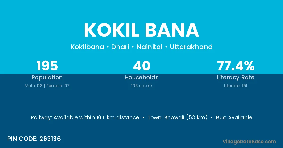
Kokil Bana village is located in the Dhari Tehsil of the Nainital district in Uttarakhand .
Block / Tehsil → Dhari
District → Nainital
State → Uttarakhand
According to Census 2011 information, the village code of Kokil Bana village is 263136.
Kokil Bana village has a total population of 195 people, of which 98 are males and 97 are females.
The literacy rate of Kokil Bana village is 77.44%. Male literacy stands at 84.69% and female literacy at 70.10%.
There are approximately 40 households in Kokil Bana village.
Bhowali (53 km) is the nearest town to Kokil Bana village for major economic activities and is located approximately 53 km away.
The population of Kokil Bana village is distributed between literate and illiterate residents as follows:
| Particulars | Male | Female | Total |
|---|---|---|---|
| Literate | 83 | 68 | 151 |
| Illiterate | 15 | 29 | 44 |
| Total | 98 | 97 | 195 |
Source: Census 2011
| Village | District |
|---|---|
| Bana | Gaya |
| Bana | Janjgir Champa |
| Bana | Kachchh |
| Bana | Reasi |
| Bana | Garhwa |
| Bana | Garhwa |
| Bana | Latehar |
| Bana | Palamu |
| Bana | Saraikela Kharsawan |
| Bana | Saraikela Kharsawan |
| Bana | Baleshwar |
| Bana | Shahid Bhagat Singh Nagar |
| Bana | Bikaner |
| Bana | Mathura |
| Bana | Meerut |
| Bana | Nainital |
| Bana | Pithoragarh |
| Boranshi | Nainital |
| Chaukhuta | Nainital |
| Chaukhuta Chak Gajar | Nainital |
| Chaukhuta Chak Rooshi | Nainital |
| Sunkiya | Nainital |
No reviews yet. Be the first to review this village!
Available within 10+ km distance
Available within village
Available within village