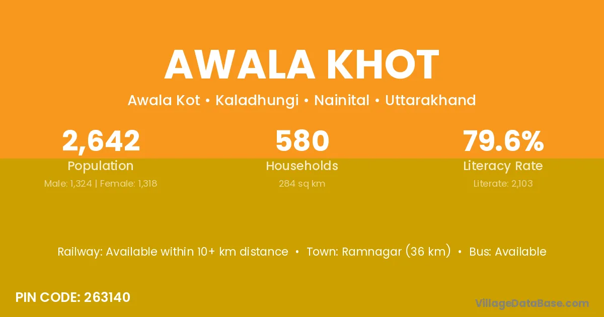
Awala Khot village is located in the Kaladhungi Tehsil of the Nainital district in Uttarakhand .
Block / Tehsil → Kaladhungi
District → Nainital
State → Uttarakhand
According to Census 2011 information, the village code of Awala Khot village is 263140.
Awala Khot village has a total population of 2,642 people, of which 1,324 are males and 1,318 are females.
The literacy rate of Awala Khot village is 79.60%. Male literacy stands at 85.05% and female literacy at 74.13%.
There are approximately 580 households in Awala Khot village.
Ramnagar (36 km) is the nearest town to Awala Khot village for major economic activities and is located approximately 36 km away.
The population of Awala Khot village is distributed between literate and illiterate residents as follows:
| Particulars | Male | Female | Total |
|---|---|---|---|
| Literate | 1,126 | 977 | 2,103 |
| Illiterate | 198 | 341 | 539 |
| Total | 1,324 | 1,318 | 2,642 |
Source: Census 2011
| Village | District |
|---|---|
| Bacha Bangar | Nainital |
| Dhamid Deh | Nainital |
| Gotia | Chatra |
| Gotia | Nainital |
| Haripur Roopsingh | Nainital |
| Jalaliaganja | Nainital |
| Khimaua Pipal | Nainital |
| Majhera | Kangra |
| Majhera | Guna |
| Majhera | Sagar |
| Majhera | Sagar |
| Majhera | Shivpuri |
| Majhera | Vidisha |
| Majhera | Baran |
| Majhera | Rajsamand |
| Majhera | Bageshwar |
| Majhera | Champawat |
| Majhera | Champawat |
| Majhera | Nainital |
| Majhera | Nainital |
| Majhera | Nainital |
| Majhera | Pithoragarh |
| Nathujala | Nainital |
| Selsiya | Nainital |
| Sonajala Naya Abad | Nainital |
| Sonjala Narsingh | Nainital |
No reviews yet. Be the first to review this village!
Available within 10+ km distance
Available within village
Available within village