District → Uttarkashi
State → Uttarakhand
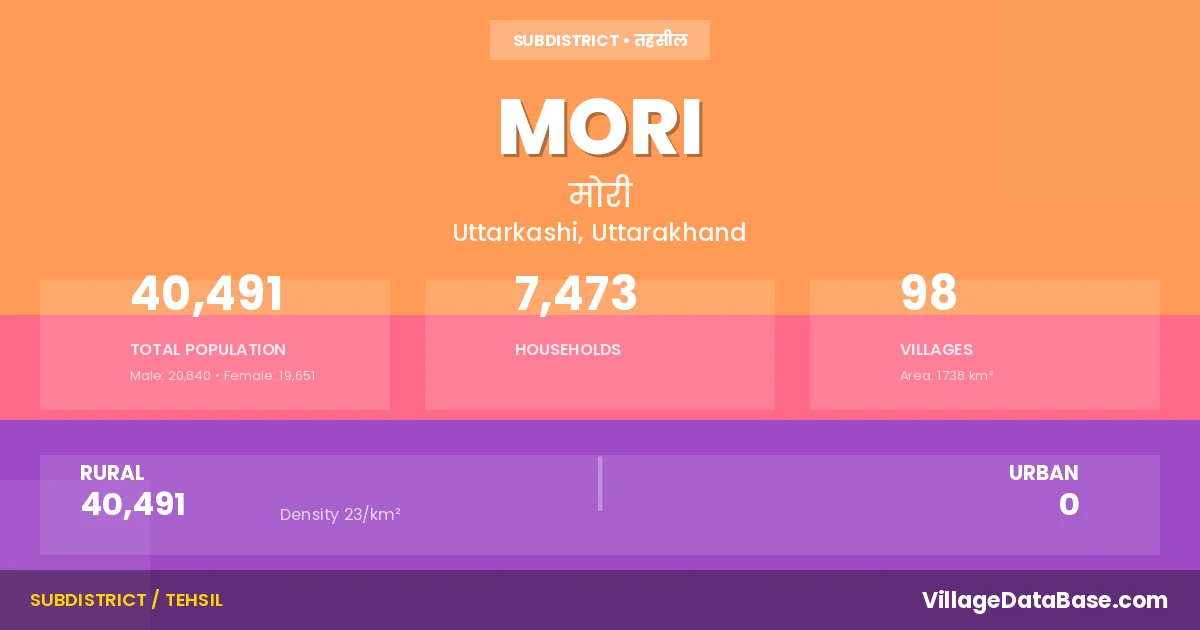
Mori is a town and Tehsil in the Uttarkashi district of the Uttarakhand. In India, a Tehsil is a subdivision of a district responsible for the administration and revenue collection of a specific area within the district. Tehsils play a crucial role in the local governance structure, contributing significantly to the development and administration of their communities.
According to the 2011 census The total area of Mori Tehsil is 1738 km², with a population of 40491 people. The population density is 23 inhabitants per square kilometre, and there are approximately 7473 houses in the sub district.
Mori Tehsil comprises about 98 villages. Below is a list of these villages along with information about their respective gram panchayats and the nearest town:
| # | Village Name | Gram Panchayat | Nearest Town |
|---|---|---|---|
| 1 | Adasu | Jhotadi | Rohadoo (49 km) |
| 2 | Arakot | Arakot | Rohadoo (36 km) |
| 3 | Balawate | Balawate | Rohadoo (53 km) |
| 4 | Barnali | Gokul | Rohadoo (47 km) |
| 5 | Bhakwar | Bhankwad | Barkot (94 km) |
| 6 | Bhitri | Bhitri | Barkot (82 km) |
| 7 | Bhutanu | Bhutanu | Barkot (103 km) |
| 8 | Chiwan | Chinwa | Rohadoo (50 km) |
| 9 | Dagoli | Dagoli | Barkot (112 km) |
| 10 | Damti Thunara | Damti Thunara | Rohadoo (44 km) |
| 11 | Danda Gaon | Ramalgaon | Barkot (65 km) |
| 12 | Dargar Gaon | Dangangaon | Barkot (82 km) |
| 13 | Devjani | Devjani | Barkot (58 km) |
| 14 | Devta Range | Barkot (77 km) | |
| 15 | Dewal | Pujeli | Barkot (83 km) |
| 16 | Dewara | Devra | Barkot (78 km) |
| 17 | Dewti | Dewti | Barkot (79 km) |
| 18 | Dhara | Jhotadi | Rohadoo (58 km) |
| 19 | Dhatmeer | Dhatmeer | Barkot (105 km) |
| 20 | Dobhal Gaon | Dobhalgaon | Barkot (70 km) |
| 21 | Doni | Doni | Barkot (94 km) |
| 22 | Duchanu | Duchanu | Barkot (113 km) |
| 23 | Fitari | Fitari | Barkot (105 km) |
| 24 | Gainchwan Gaon | Gainchwan Gaon | Barkot (77 km) |
| 25 | Gamri | Mainjni | Barkot (99 km) |
| 26 | Gangar | Gangar | Barkot (110 km) |
| 27 | Gawalgaun | Khanna | Barkot (93 km) |
| 28 | Gokul | Gokul | Rohadoo (57 km) |
| 29 | Gurari | Gurari | Barkot (74 km) |
| 30 | Haltari | Haltadi | Barkot (82 km) |
| 31 | Halywari | Hadwari | Barkot (23 km) |
| 32 | Jagta | Chinwa | Rohadoo (51 km) |
| 33 | Jakhol | Jakhol | Barkot (97 km) |
| 34 | Jewanu | Devjani | Barkot (59 km) |
| 35 | Jhotari | Jhotadi | Rohadoo (54 km) |
| 36 | Kalap | Kalap | Barkot (87 km) |
| 37 | Kalich | Kalich | Rohadoo (42 km) |
| 38 | Kamra | Pokhri | Barkot (62 km) |
| 39 | Kasla | Kasla | Barkot (117 km) |
| 40 | Khanna | Khanna | Barkot (94 km) |
| 41 | Khanyasani | Khanyasani | Barkot (79 km) |
| 42 | Kharsari | Kharsadi | Barkot (58 km) |
| 43 | Khedmi | Khedmi | Barkot (64 km) |
| 44 | Kiranu | Kiranu | Barkot (109 km) |
| 45 | Kirauli | Pawali | Barkot (106 km) |
| 46 | Kotgaon | Kotgaon | Barkot (81 km) |
| 47 | Kotigad Range | Barkot (24 km) | |
| 48 | Kukrera | Kukreda | Barkot (94 km) |
| 49 | Kunara | Kunara | Barkot (61 km) |
| 50 | Liwari | Liwari | Barkot (115 km) |
| 51 | Ludrala | Pokhri | Barkot (62 km) |
| 52 | Maijyani | Mainjni | Barkot (105 km) |
| 53 | Makuri | Makudi | Barkot (114 km) |
| 54 | Masari | Masari | Barkot (98 km) |
| 55 | Mautar | Mautar | Barkot (68 km) |
| 56 | Metrusa | Khedmi | Barkot (62 km) |
| 57 | Monda | Mounda | Rohadoo (55 km) |
| 58 | Naitwar | Naitwar | Barkot (76 km) |
| 59 | Nanai | Nanai | Barkot (65 km) |
| 60 | Nuranu | Nuranu | Barkot (90 km) |
| 61 | Odata | Odata | Barkot (68 km) |
| 62 | Osala | Osla | Barkot (114 km) |
| 63 | Paisar | Painsar | Barkot (75 km) |
| 64 | Panw Malla | Pav Talla | Barkot (94 km) |
| 65 | Panw Talla | Pav Talla | Barkot (94 km) |
| 66 | Pasa | Kunara | Barkot (73 km) |
| 67 | Pawali | Pawali | Barkot (103 km) |
| 68 | Pawani | Pawani | Barkot (113 km) |
| 69 | Petri | Saransh | Barkot (69 km) |
| 70 | Pokhri | Pokhri | Barkot (62 km) |
| 71 | Pujeli | Pujeli | Barkot (83 km) |
| 72 | Rala | Kasla | Barkot (114 km) |
| 73 | Ramal Gaon | Barkot (64 km) | |
| 74 | Regcha | Regcha | Barkot (106 km) |
| 75 | Rupin Range | Gainchwan Gaon | Barkot (26 km) |
| 76 | Salra | Salra | Barkot (71 km) |
| 77 | Sandra Range | Barkot (68 km) | |
| 78 | Sankari | Saur | Barkot (86 km) |
| 79 | Sankari Range | Barkot (92 km) | |
| 80 | Saransh | Saransh | Barkot (72 km) |
| 81 | Satta | Satta | Barkot (94 km) |
| 82 | Saturi | Satudi | Barkot (102 km) |
| 83 | Sauni | Satudi | Barkot (104 km) |
| 84 | Saur | Saur | Barkot (87 km) |
| 85 | Sewa | Sewa | Barkot (101 km) |
| 86 | Sidri | Sidri | Barkot (84 km) |
| 87 | Singtur Range | Barkot (66 km) | |
| 88 | Sirga | Sirga | Barkot (100 km) |
| 89 | Suchan Gaon | Haltadi | Barkot (82 km) |
| 90 | Sunkundi | Pav Talla | Barkot (96 km) |
| 91 | Supin Range | Gainchwan Gaon | Barkot (76 km) |
| 92 | Thali | Thali | Barkot (70 km) |
| 93 | Thapali | Balawate | Rohadoo (53 km) |
| 94 | Wainol | Mautar | Barkot (69 km) |
| 95 | Wamsu | Odata | Barkot (67 km) |
| 96 | Wari | Bari | Barkot (100 km) |
| 97 | Wegal | Bengal | Barkot (77 km) |
| 98 | Wigsari | Bingsari | Barkot (59 km) |
The population is distributed between urban and rural areas as follows:
| Particulars | Rural | Urban | Total |
|---|---|---|---|
| Total Population | 40491 | 0 | 40491 |
| Male Population | 20840 | 0 | 20840 |
| Female Population | 19651 | 0 | 19651 | Population Density | 23 / km² | 23 / km² |
The distribution of households in the Mori is:
| Rural Households | Urban Households | Total Households |
|---|---|---|
| 7473 | 0 | 7473 |
Q: What is Mori?
A: Mori is a town and in the Uttarkashi district of the Uttarakhand.
Q: What is the total area of Mori Tehsil?
A: The total area of Mori Tehsil is 1738 km².
Q: What is the population of Mori Tehsil according to the 2011 census?
A: According to the 2011 census, the population of Mori Tehsil is 40491.
Q: What is the population density of Mori Tehsil?
A: The population density of Mori Tehsil is 23 inhabitants per square kilometre.
Q: How many houses are there in Mori Tehsil?
A: There are approximately 7473 houses in Mori Tehsil.
Q: How many villages are there in Mori Tehsil?
A: There are about 98 villages in Mori Tehsil.
Q: Which is the largest village by population in Mori Tehsil?
A: The largest village by population in Mori Tehsil is Jakhol, with 1601 people.
Q: Which is the smallest village by population in Mori Tehsil?
A: The smallest village by population in Mori Tehsil is Rupin Range, with 3 people.
Q: Which is the largest village by area in Mori Tehsil?
A: The largest village by area in Mori Tehsil is Sankari Range, with 49984 km².
Q: Which is the smallest village by area in Mori Tehsil?
A: The smallest village by area in Mori Tehsil is Metrusa, with 17 km².
Q: What is the population distribution between urban and rural areas in Mori Tehsil?
A: The population distribution in Mori Tehsil is entirely rural, with a total rural population of 40491.
Q: What is the male population of Mori Tehsil?
A: The male population of Mori Tehsil is 20840.
Q: What is the female population of Mori Tehsil?
A: The female population of Mori Tehsil is 19651.
Q: How is the household distribution in Mori Tehsil?
A: The household distribution in Mori Tehsil is entirely rural, with a total of 7473 households.
Q: How many villages in Mori Tehsil have a population of less than 100?
A: There are 8 villages in Mori Tehsil with a population of less than 100.
Q: How many villages in Mori Tehsil have a population between 100 and 499?
A: There are 67 villages in Mori Tehsil with a population between 100 and 499.
Q: How many villages in Mori Tehsil have a population between 500 and 999?
A: There are 19 villages in Mori Tehsil with a population between 500 and 999.
Q: How many villages in Mori Tehsil have a population between 1000 and 1999?
A: There are 4 villages in Mori Tehsil with a population between 1000 and 1999.
| Total Population | Villages in Sub District Of Mori |
|---|---|
| Less than 100 | 8 |
| 100-499 | 67 |
| 500-999 | 19 |
| 1000-1999 | 4 |