Hirbandh: A Town and Subdivision in Bankura district
District → Bankura
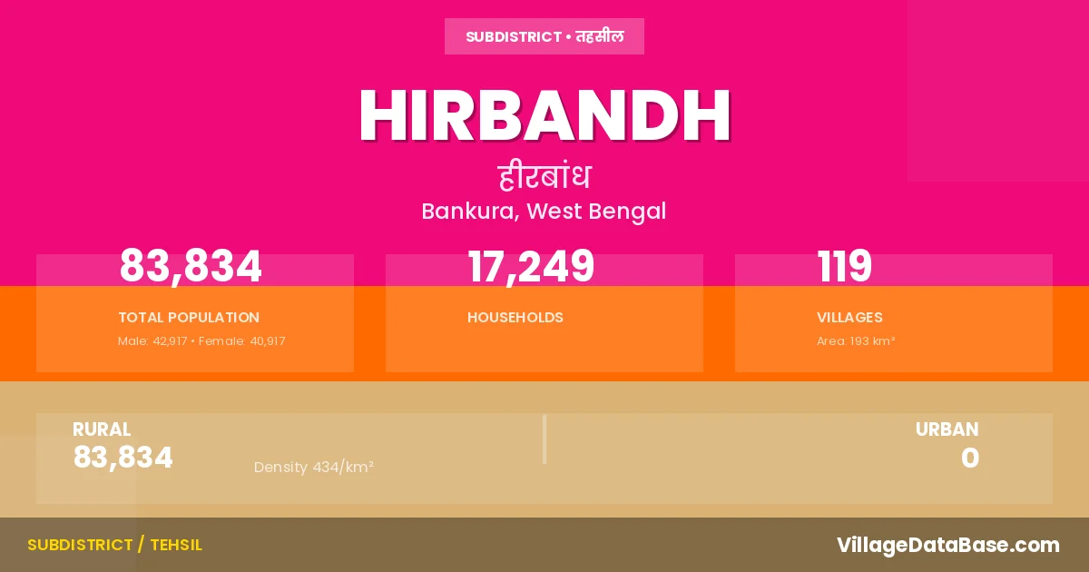
State → West Bengal
Hirbandh is a town and Subdivision in the Bankura district of the West Bengal. In India, a Subdivision is a subdivision of a district responsible for the administration and revenue collection of a specific area within the district. Subdivisions play a crucial role in the local governance structure, contributing significantly to the development and administration of their communities.
According to the 2011 census The total area of Hirbandh Subdivision is 193 km², with a population of 83834 people. The population density is 434 inhabitants per square kilometre, and there are approximately 17249 houses in the sub district.
Hirbandh Subdivision comprises about 119 villages. Below is a list of these villages along with information about their respective gram panchayats and the nearest town:
| # | Village Name | Gram Panchayat | Nearest Town |
|---|---|---|---|
| 1 | Amjhuri | Moshiara | Khatra (16 km) |
| 2 | Aral Chhota | Molian | Hirbandh |
| 3 | Aralbara | Molian | Khatra (24 km) |
| 4 | Arjunda | Hirbandh | Khatra (11 km) |
| 5 | Asberya | Baharamuri | Khatra (14 km) |
| 6 | Ashatara | Molian | Khatra (19 km) |
| 7 | Bagaldhara | Baharamuri | Khatra (16 km) |
| 8 | Bagjobra | Hirbandh | Khatra (6 km) |
| 9 | Baharamuri | Baharamuri | Khatra (11 km) |
| 10 | Bamni | Moshiara | Khatra (21 km) |
| 11 | Banagarya | Baharamuri | Khatra (12 km) |
| 12 | Bangopalpur | Gopalpur | Khatra (32 km) |
| 13 | Bansol | Gopalpur | Khatra (25 km) |
| 14 | Bara Gajra | Baharamuri | Khatra (13 km) |
| 15 | Barkania | Hirbandh | Khatra (14 km) |
| 16 | Basudebpur | Hirbandh | Khatra (14 km) |
| 17 | Batikara | Gopalpur | Khatra (26 km) |
| 18 | Bauridihi | Hirbandh | Khatra (13 km) |
| 19 | Belkanlia | Hirbandh | Khatra (9 km) |
| 20 | Benagaria | Molian | Khatra (19 km) |
| 21 | Bhedua | Moshiara | Khatra (20 km) |
| 22 | Bhelai Diha | Hirbandh | Khatra (14 km) |
| 23 | Bhogra | Baharamuri | Khatra (14 km) |
| 24 | Bhojda | Hirbandh | Khatra (6 km) |
| 25 | Bhuakana | Hirbandh | Khatra (13 km) |
| 26 | Bhubandihi | Baharamuri | Khatra (8 km) |
| 27 | Bhuchu Dungri | Hirbandh | Khatra (16 km) |
| 28 | Bhutardihi | Moshiara | Khatra (21 km) |
| 29 | Bijardihi | Moshiara | Khatra (21 km) |
| 30 | Biradihi | Moshiara | Khatra (26 km) |
| 31 | Brahma Danga | Molian | Khatra (18 km) |
| 32 | Chaka Doba | Hirbandh | Khatra (16 km) |
| 33 | Chakadoba | Moshiara | Khatra (13 km) |
| 34 | Chalka | Gopalpur | Khatra (32 km) |
| 35 | Chanpasol | Molian | Khatra (18 km) |
| 36 | Chatanibaid | Gopalpur | Khatra (32 km) |
| 37 | Damodarpur | Molian | Khatra (22 km) |
| 38 | Debidia | Molian | Khatra (25 km) |
| 39 | Deulagara | Hirbandh | Khatra (5 km) |
| 40 | Deuli | Molian | Khatra (21 km) |
| 41 | Dhairapara | Hirbandh | Khatra (14 km) |
| 42 | Dhajamanipur | Baharamuri | Khatra (13 km) |
| 43 | Dhanarangi | Gopalpur | Khatra (28 km) |
| 44 | Dhanga Dungri | Hirbandh | Hirbandh |
| 45 | Dharampur | Moshiara | Khatra (22 km) |
| 46 | Dias Dihi | Baharamuri | Khatra (13 km) |
| 47 | Dighi | Baharamuri | Khatra (14 km) |
| 48 | Diktor | Moshiara | Khatra (20 km) |
| 49 | Domohani | Hirbandh | Khatra (5 km) |
| 50 | Dulalpur | Molian | Khatra (21 km) |
| 51 | Elora | Gopalpur | Khatra (32 km) |
| 52 | Fetapur | Gopalpur | Khatra (27 km) |
| 53 | Gobarda | Hirbandh | Khatra (2 km) |
| 54 | Golakpur | Gopalpur | Hirbandh |
| 55 | Gopalpur | Moshiara | Khatra (32 km) |
| 56 | Guniada | Gopalpur | Khatra (32 km) |
| 57 | Harirampur | Gopalpur | Khatra (32 km) |
| 58 | Hir Bandh | Hirbandh | Khatra (14 km) |
| 59 | Hirakhon | Molian | Khatra (19 km) |
| 60 | Husum Danga | Baharamuri | Khatra (16 km) |
| 61 | Indpur | Hirbandh | Khatra (5 km) |
| 62 | Itamara | Hirbandh | Khatra (11 km) |
| 63 | Jadurbankata | Baharamuri | Khatra (16 km) |
| 64 | Jagatpur | Hirbandh | Khatra (16 km) |
| 65 | Jambeda | Hirbandh | Khatra (14 km) |
| 66 | Jambedya | Baharamuri | Hirbandh |
| 67 | Jamdahara | Hirbandh | Khatra (11 km) |
| 68 | Jhapandihi | Moshiara | Khatra (21 km) |
| 69 | Jharia Kucha | Gopalpur | Khatra (25 km) |
| 70 | Jhat Pukhuria | Hirbandh | Khatra (14 km) |
| 71 | Jibanpur | Moshiara | Khatra (21 km) |
| 72 | Kadamkarali | Hirbandh | Khatra (6 km) |
| 73 | Kadia | Gopalpur | Khatra (28 km) |
| 74 | Kaliahuta | Baharamuri | Khatra (16 km) |
| 75 | Kaliapathar | Baharamuri | Khatra (13 km) |
| 76 | Kendua | Moshiara | Hirbandh |
| 77 | Khandarani | Hirbandh | Khatra (6 km) |
| 78 | Khayer Kundi | Molian | Khatra (26 km) |
| 79 | Kundurka | Moshiara | Khatra (21 km) |
| 80 | Lachaipur | Gopalpur | Khatra (24 km) |
| 81 | Lalbazar | Molian | Khatra (19 km) |
| 82 | Lalraydihi | Hirbandh | Khatra (8 km) |
| 83 | Lutia | Moshiara | Khatra (22 km) |
| 84 | Madhupur | Hirbandh | Khatra (16 km) |
| 85 | Mahal Danga | Molian | Khatra (19 km) |
| 86 | Maiti Bandh | Baharamuri | Khatra (14 km) |
| 87 | Malian | Molian | Khatra (22 km) |
| 88 | Manora | Moshiara | Hirbandh |
| 89 | Masanjhar | Baharamuri | Khatra (8 km) |
| 90 | Mirgi | Hirbandh | Khatra (13 km) |
| 91 | Mosiara | Moshiara | Khatra (19 km) |
| 92 | Nanda | Gopalpur | Khatra (25 km) |
| 93 | Naria | Molian | Khatra (19 km) |
| 94 | Nipania | Molian | Khatra (18 km) |
| 95 | Nischintapur | Baharamuri | Khatra (13 km) |
| 96 | Nowadihi | Molian | Khatra (21 km) |
| 97 | Paira | Moshiara | Khatra (22 km) |
| 98 | Pakhuria | Molian | Khatra (24 km) |
| 99 | Palashbani | Hirbandh | Khatra (6 km) |
| 100 | Patasimul | Hirbandh | Khatra (7 km) |
| 101 | Pathardihi | Baharamuri | Khatra (11 km) |
| 102 | Ranga | Molian | Khatra (20 km) |
| 103 | Rangamati | Baharamuri | Khatra (8 km) |
| 104 | Rangametia | Moshiara | Khatra (24 km) |
| 105 | Salapahari | Gopalpur | Khatra (30 km) |
| 106 | Shyamnagar | Molian | Khatra (22 km) |
| 107 | Shyampur | Baharamuri | Khatra (15 km) |
| 108 | Simlabandh | Moshiara | Khatra (20 km) |
| 109 | Simul Kundi | Molian | Khatra (14 km) |
| 110 | Sitarampur | Moshiara | Khatra (16 km) |
| 111 | Soul Ponamara | Moshiara | Khatra (21 km) |
| 112 | Talgaria | Baharamuri | Khatra (11 km) |
| 113 | Tentulia | Molian | Khatra (22 km) |
| 114 | Tilabad | Gopalpur | Khatra (27 km) |
| 115 | Tilabani | Hirbandh | Khatra (9 km) |
| 116 | Tirsulia | Hirbandh | Khatra (11 km) |
| 117 | Topabari | Baharamuri | Khatra (13 km) |
| 118 | Uganpathar | Baharamuri | Khatra (13 km) |
| 119 | Uparhir | Baharamuri | Khatra (9 km) |
The population is distributed between urban and rural areas as follows:
| Particulars | Rural | Urban | Total |
|---|---|---|---|
| Total Population | 83834 | 0 | 83834 |
| Male Population | 42917 | 0 | 42917 |
| Female Population | 40917 | 0 | 40917 | Population Density | 434 / km² | 434 / km² |
The distribution of households in the Hirbandh is:
| Rural Households | Urban Households | Total Households |
|---|---|---|
| 17249 | 0 | 17249 |
Q: What is Hirbandh?
A: Hirbandh is a town and in the Bankura district of the West Bengal.
Q: What is the total area of Hirbandh Subdivision?
A: The total area of Hirbandh Subdivision is 193 km².
Q: What is the population of Hirbandh Subdivision according to the 2011 census?
A: According to the 2011 census, the population of Hirbandh Subdivision is 83834.
Q: What is the population density of Hirbandh Subdivision?
A: The population density of Hirbandh Subdivision is 434 inhabitants per square kilometre.
Q: How many houses are there in Hirbandh Subdivision?
A: There are approximately 17249 houses in Hirbandh Subdivision.
Q: How many villages are there in Hirbandh Subdivision?
A: There are about 119 villages in Hirbandh Subdivision.
Q: Which is the largest village by population in Hirbandh Subdivision?
A: The largest village by population in Hirbandh Subdivision is Mosiara, with 2559 people.
Q: Which is the smallest village by population in Hirbandh Subdivision?
A: The smallest village by population in Hirbandh Subdivision is Aral Chhota, with 0 people.
Q: Which is the largest village by area in Hirbandh Subdivision?
A: The largest village by area in Hirbandh Subdivision is Jharia Kucha, with 567 km².
Q: Which is the smallest village by area in Hirbandh Subdivision?
A: The smallest village by area in Hirbandh Subdivision is Jamdahara, with 17 km².
Q: What is the population distribution between urban and rural areas in Hirbandh Subdivision?
A: The population distribution in Hirbandh Subdivision is entirely rural, with a total rural population of 83834.
Q: What is the male population of Hirbandh Subdivision?
A: The male population of Hirbandh Subdivision is 42917.
Q: What is the female population of Hirbandh Subdivision?
A: The female population of Hirbandh Subdivision is 40917.
Q: How is the household distribution in Hirbandh Subdivision?
A: The household distribution in Hirbandh Subdivision is entirely rural, with a total of 17249 households.
Q: How many villages in Hirbandh Subdivision have a population of less than 100?
A: There are 11 villages in Hirbandh Subdivision with a population of less than 100.
Q: How many villages in Hirbandh Subdivision have a population between 100 and 499?
A: There are 49 villages in Hirbandh Subdivision with a population between 100 and 499.
Q: How many villages in Hirbandh Subdivision have a population between 500 and 999?
A: There are 32 villages in Hirbandh Subdivision with a population between 500 and 999.
Q: How many villages in Hirbandh Subdivision have a population between 1000 and 1999?
A: There are 21 villages in Hirbandh Subdivision with a population between 1000 and 1999.
Q: How many villages in Hirbandh Subdivision have a population between 2000 and 2999?
A: There is 6 village in Hirbandh Subdivision with a population between 2000 and 2999.
| Total Population | Villages in Sub District Of Hirbandh |
|---|---|
| Less than 100 | 11 |
| 100-499 | 49 |
| 500-999 | 32 |
| 1000-1999 | 21 |
| 2000-2999 | 6 |