Ausgram I: A Town and Subdivision in Barddhaman district
District → Barddhaman
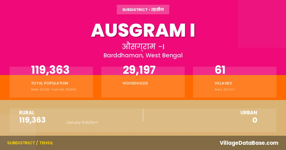
State → West Bengal
Ausgram I is a town and Subdivision in the Barddhaman district of the West Bengal. In India, a Subdivision is a subdivision of a district responsible for the administration and revenue collection of a specific area within the district. Subdivisions play a crucial role in the local governance structure, contributing significantly to the development and administration of their communities.
According to the 2011 census The total area of Ausgram I Subdivision is 221 km², with a population of 119363 people. The population density is 540 inhabitants per square kilometre, and there are approximately 29197 houses in the sub district.
Ausgram I Subdivision comprises about 61 villages. Below is a list of these villages along with information about their respective gram panchayats and the nearest town:
| # | Village Name | Gram Panchayat | Nearest Town |
|---|---|---|---|
| 1 | Alefnagar | Ausgram | Gushkara (11 km) |
| 2 | Aligram | Guskara Ii | Gushkara (10 km) |
| 3 | Alutia | Dignagar Ii | Gushkara (5 km) |
| 4 | Asinda | Bilwagram | Gurhara (18 km) |
| 5 | Ausgram | Ausgram | Gushkara (8 km) |
| 6 | Ausgram Chak | Ausgram | Ausgram I |
| 7 | Baburbandh | Berenda | Gushkara (17 km) |
| 8 | Bahamanpur | Ausgram | Gushkara (25 km) |
| 9 | Ban Nabagram | Ausgram | Gushkara (13 km) |
| 10 | Bara | Bilwagram | Gushkara (10 km) |
| 11 | Bara Chatra | Ausgram | Gushkara (18 km) |
| 12 | Batagram | Ukta | Gushkara (10 km) |
| 13 | Belari | Bilwagram | Burdwan (18 km) |
| 14 | Belgram | Bilwagram | Gushkara (11 km) |
| 15 | Beluti | Berenda | Gushkara (16 km) |
| 16 | Beranda | Berenda | Gushkara (18 km) |
| 17 | Bhada | Bilwagram | Gushkara (16 km) |
| 18 | Bhatgonna | Dignagar I | Gushkara (10 km) |
| 19 | Bhota | Bilwagram | Gushkara (18 km) |
| 20 | Brajapur | Bilwagram | Gurkara (16 km) |
| 21 | Chonari | Bilwagram | Gurhara (22 km) |
| 22 | Deasa | Guskara Ii | Gushkara (10 km) |
| 23 | Digha | Ukta | Gushkara (4 km) |
| 24 | Dignagar | Dignagar I | Gushkara (10 km) |
| 25 | Dwariapur | Dignagar Ii | Gushkara (10 km) |
| 26 | Gangarampur | Ukta | Ghuskara (8 km) |
| 27 | Gobindapur Purbba | Ukta | Gushkara (6 km) |
| 28 | Gonna | Dignagar I | Gushkara (10 km) |
| 29 | Jadabganj | Dignagar Ii | Gushkara (10 km) |
| 30 | Jaykrishnapur | Berenda | Gushkara (21 km) |
| 31 | Kalyanpur | Ukta | Gushkara (11 km) |
| 32 | Karanji | Bilwagram | Burdwan (20 km) |
| 33 | Karatia | Ausgram | Gushkara (10 km) |
| 34 | Kayrapur | Bilwagram | Gushkara (14 km) |
| 35 | Kumarganj | Dignagar Ii | Gushkara (15 km) |
| 36 | Kunjanagar | Ausgram | Ausgram I |
| 37 | Kurumba | Berenda | Gushkara (16 km) |
| 38 | Lakshmiganj | Dignagar Ii | Gushkara (5 km) |
| 39 | Majhergram | Berenda | Gushkara (10 km) |
| 40 | Mallikpur | Berenda | Gushkara (15 km) |
| 41 | Nabagram | Berenda | Gushkara (13 km) |
| 42 | Naoda | Guskara Ii | Gushkara (10 km) |
| 43 | Nripatigram | Berenda | Gushkara (15 km) |
| 44 | Parasurampur | Ukta | Gushkara (7 km) |
| 45 | Pichkuri | Baghar I | Gushkar (9 km) |
| 46 | Purbba Tati | Ausgram | Gushkara (15 km) |
| 47 | Ramchandrapur | Ausgram | Gushkara (16 km) |
| 48 | Sahapur | Berenda | Gushkara (12 km) |
| 49 | Shibada | Guskara Ii | Gushkara (5 km) |
| 50 | Shibbati | Ukta | Gushkara (5 km) |
| 51 | Shitalgram | Ukta | Gushkara (7 km) |
| 52 | Silut | Berenda | Gushkara (15 km) |
| 53 | Soara | Ukta | Gushkara (6 km) |
| 54 | Somaipur | Berenda | Gushkara (4 km) |
| 55 | Srikrishnapur | Berenda | Gushkara (17 km) |
| 56 | Srinagar | Berenda | Ausgram I |
| 57 | Sundalpur | Ukta | Gushkara (12 km) |
| 58 | Takipur | Bilwagram | Gushkara (20 km) |
| 59 | Telata | Dignagar I | Gushkara (2 km) |
| 60 | Ukta | Ukta | Guskara (10 km) |
| 61 | Warishpur | Ausgram | Gushkara (14 km) |
The population is distributed between urban and rural areas as follows:
| Particulars | Rural | Urban | Total |
|---|---|---|---|
| Total Population | 119363 | 0 | 119363 |
| Male Population | 60521 | 0 | 60521 |
| Female Population | 58842 | 0 | 58842 | Population Density | 540 / km² | 540 / km² |
The distribution of households in the Ausgram I is:
| Rural Households | Urban Households | Total Households |
|---|---|---|
| 29197 | 0 | 29197 |
Q: What is Ausgram I?
A: Ausgram I is a town and in the Barddhaman district of the West Bengal.
Q: What is the total area of Ausgram I Subdivision?
A: The total area of Ausgram I Subdivision is 221 km².
Q: What is the population of Ausgram I Subdivision according to the 2011 census?
A: According to the 2011 census, the population of Ausgram I Subdivision is 119363.
Q: What is the population density of Ausgram I Subdivision?
A: The population density of Ausgram I Subdivision is 540 inhabitants per square kilometre.
Q: How many houses are there in Ausgram I Subdivision?
A: There are approximately 29197 houses in Ausgram I Subdivision.
Q: How many villages are there in Ausgram I Subdivision?
A: There are about 61 villages in Ausgram I Subdivision.
Q: Which is the largest village by population in Ausgram I Subdivision?
A: The largest village by population in Ausgram I Subdivision is Dignagar, with 8313 people.
Q: Which is the smallest village by population in Ausgram I Subdivision?
A: The smallest village by population in Ausgram I Subdivision is Ausgram Chak, with 0 people.
Q: Which is the largest village by area in Ausgram I Subdivision?
A: The largest village by area in Ausgram I Subdivision is Dignagar, with 1571 km².
Q: Which is the smallest village by area in Ausgram I Subdivision?
A: The smallest village by area in Ausgram I Subdivision is Ausgram Chak, with 40 km².
Q: What is the population distribution between urban and rural areas in Ausgram I Subdivision?
A: The population distribution in Ausgram I Subdivision is entirely rural, with a total rural population of 119363.
Q: What is the male population of Ausgram I Subdivision?
A: The male population of Ausgram I Subdivision is 60521.
Q: What is the female population of Ausgram I Subdivision?
A: The female population of Ausgram I Subdivision is 58842.
Q: How is the household distribution in Ausgram I Subdivision?
A: The household distribution in Ausgram I Subdivision is entirely rural, with a total of 29197 households.
Q: How many villages in Ausgram I Subdivision have a population of less than 100?
A: There are 3 villages in Ausgram I Subdivision with a population of less than 100.
Q: How many villages in Ausgram I Subdivision have a population between 100 and 499?
A: There are 6 villages in Ausgram I Subdivision with a population between 100 and 499.
Q: How many villages in Ausgram I Subdivision have a population between 500 and 999?
A: There are 10 villages in Ausgram I Subdivision with a population between 500 and 999.
Q: How many villages in Ausgram I Subdivision have a population between 1000 and 1999?
A: There are 14 villages in Ausgram I Subdivision with a population between 1000 and 1999.
Q: How many villages in Ausgram I Subdivision have a population between 2000 and 2999?
A: There is 16 village in Ausgram I Subdivision with a population between 2000 and 2999.
Q: How many villages in Ausgram I Subdivision have a population between 3000 and 3999?
A: There is 5 village in Ausgram I Subdivision with a population between 3000 and 3999.
Q: How many villages in Ausgram I Subdivision have a population between 4000 and 4999?
A: There is 5 village in Ausgram I Subdivision with a population between 4000 and 4999.
Q: How many villages in Ausgram I Subdivision have a population of 5000 and above?
A: There is 2 village in Ausgram I Subdivision with a population of 5000 and above.
| Total Population | Villages in Sub District Of Ausgram I |
|---|---|
| Less than 100 | 3 |
| 100-499 | 6 |
| 500-999 | 10 |
| 1000-1999 | 14 |
| 2000-2999 | 16 |
| 3000-3999 | 5 |
| 4000-4999 | 5 |
| 5000 And Above | 2 |