Katwa II: A Town and Subdivision in Barddhaman district
District → Barddhaman
State → West Bengal
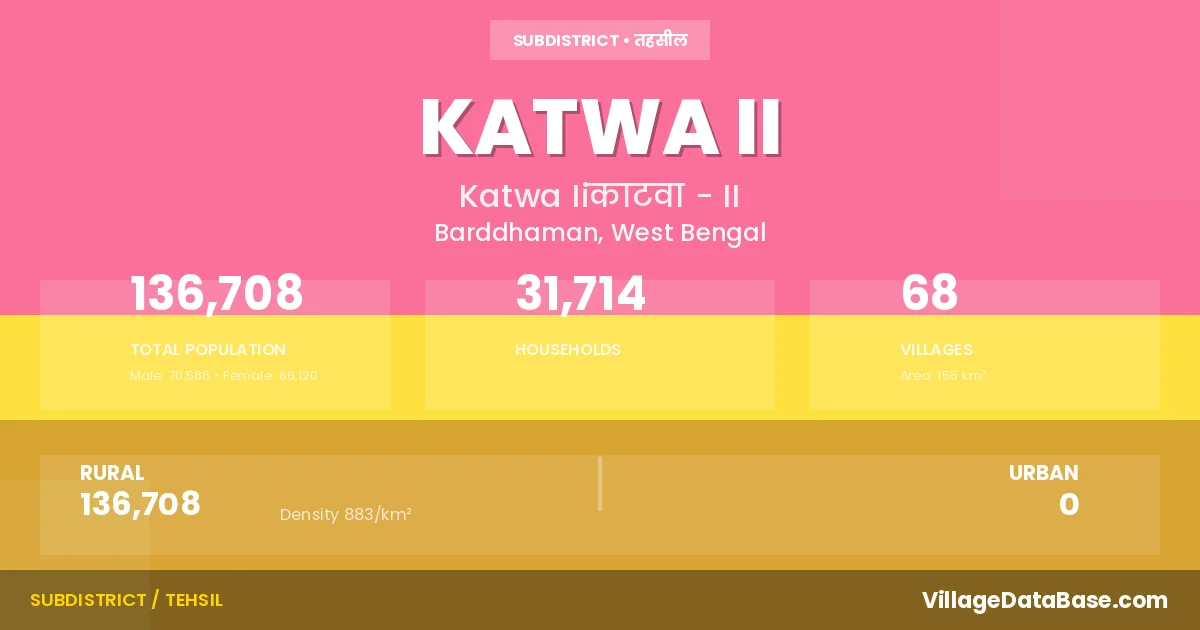
Katwa II is a town and Subdivision in the Barddhaman district of the West Bengal. In India, a Subdivision is a subdivision of a district responsible for the administration and revenue collection of a specific area within the district. Subdivisions play a crucial role in the local governance structure, contributing significantly to the development and administration of their communities.
According to the 2011 census The total area of Katwa II Subdivision is 155 km², with a population of 136708 people. The population density is 883 inhabitants per square kilometre, and there are approximately 31714 houses in the sub district.
Katwa II Subdivision comprises about 68 villages. Below is a list of these villages along with information about their respective gram panchayats and the nearest town:
| # | Village Name | Gram Panchayat | Nearest Town |
|---|---|---|---|
| 1 | Agradwip | Agradwip | Dainhat (12 km) |
| 2 | Akhra | Jagadanandspur | Dainhat (4 km) |
| 3 | Amdanga | Jagadanandspur | Dainhat (6 km) |
| 4 | Amul | Singi | Dainhat (29 km) |
| 5 | Auria | Palsona | Dainhat (19 km) |
| 6 | Baikunthapur | Sreebati | Katwa Ii |
| 7 | Bara Kulgachhi | Gazipur | Dainhat (10 km) |
| 8 | Bara Meigachhi | Singi | Dainhat (23 km) |
| 9 | Barakhanji | Jagadanandspur | Dainhat (4 km) |
| 10 | Benga | Jagadanandspur | Dainhat (2 km) |
| 11 | Bhatna Pekua | Singi | Dainhat (27 km) |
| 12 | Birbegun | Jagadanandspur | Dainhat (4 km) |
| 13 | Bishnupur | Jagadanandspur | Dainhat (5 km) |
| 14 | Chandpur | Singi | Dainhat (28 km) |
| 15 | Chanduli | Sreebati | Dainhat (8 km) |
| 16 | Char Brajanathpur | Agradwip | Dainhat (4 km) |
| 17 | Chhota Kulgachhi | Gazipur | Dainhat (10 km) |
| 18 | Chhota Meigachhi | Singi | Dainhat (14 km) |
| 19 | Deasin | Gazipur | Dainhat (13 km) |
| 20 | Deriapur | Palsona | Dainhat (12 km) |
| 21 | Dona | Karui | Dainhat (14 km) |
| 22 | Garagachhi | Gazipur | Dainhat (9 km) |
| 23 | Gaurdanga | Singi | Dainhat (24 km) |
| 24 | Gazipur | Gazipur | Dainhat (10 km) |
| 25 | Ghoranas | Jagadanandspur | Dainhat (6 km) |
| 26 | Ghumuria | Singi | Dainhat (31 km) |
| 27 | Islampur | Jagadanandspur | Dainhat (2 km) |
| 28 | Jagadanandapur | Jagadanandspur | Dainhat (3 km) |
| 29 | Jamuna Patai | Jagadanandspur | Dainhat (5 km) |
| 30 | Kabirajpur | Agradwip | Dainhat (9 km) |
| 31 | Kalikapur | Agradwip | Dainhat (8 km) |
| 32 | Karui | Karui | Kalna (14 km) |
| 33 | Khaspur | Gazipur | Dainhat (132 km) |
| 34 | Kshetpur Palashi | Agradwip | Dainhat (6 km) |
| 35 | Kuara | Palsona | Dainhat (16 km) |
| 36 | Kumri | Jagadanandspur | Dainhat (4 km) |
| 37 | Kurchi | Karui | Dainhat (10 km) |
| 38 | Makhaltor | Agradwip | Dainhat (6 km) |
| 39 | Malancha | Singi | Dainhat (14 km) |
| 40 | Mallikpur | Singi | Dainhat (28 km) |
| 41 | Mejhiari | Karui | Dainhat (14 km) |
| 42 | Mulgram | Sreebati | Dainhat (9 km) |
| 43 | Multi Krishnanagar | Sreebati | Dainhat (14 km) |
| 44 | Musthuli | Jagadanandspur | Dainhat (8 km) |
| 45 | Musthuli Chak | Jagadanandspur | Katwa Ii |
| 46 | Nandigram | Sreebati | Dainhata (10 km) |
| 47 | Nawapara | Jagadanandspur | Dainhat (2 km) |
| 48 | Nutangram | Sreebati | Dainhat (12 km) |
| 49 | Okarsha | Singi | Dainhat (23 km) |
| 50 | Okidattapur | Singi | Katwa Ii |
| 51 | Paikpara | Jagadanandspur | Dainhat |
| 52 | Palashani | Palsona | Kalna (19 km) |
| 53 | Panchberia | Jagadanandspur | Katwa Ii |
| 54 | Panjoa | Karui | Dainhat (14 km) |
| 55 | Parasurampur | Jagadanandspur | Dainhat (3 km) |
| 56 | Postgram | Sreebati | Dainhat (123 km) |
| 57 | Raghunathpur | Agradwip | Katwa Ii |
| 58 | Ramdaspur | Gazipur | Dainhat (7 km) |
| 59 | Ronda | Palsona | Dainhat (9 km) |
| 60 | Sagarpur | Singi | Katwa Ii |
| 61 | Sahapur | Agradwip | Dainhat (4 km) |
| 62 | Shila | Palsona | Dainhat (11 km) |
| 63 | Simulgachhi | Singi | Dainhat (27 km) |
| 64 | Singi | Singi | Dainhat (22 km) |
| 65 | Sribati | Sreebati | Dainhat (132 km) |
| 66 | Suagachhi | Gazipur | Dainhat (11 km) |
| 67 | Tantpara | Singi | Katwa Ii |
| 68 | Ulastikri | Karui | Dainhat (10 km) |
The population is distributed between urban and rural areas as follows:
| Particulars | Rural | Urban | Total |
|---|---|---|---|
| Total Population | 136708 | 0 | 136708 |
| Male Population | 70588 | 0 | 70588 |
| Female Population | 66120 | 0 | 66120 | Population Density | 883 / km² | 883 / km² |
The distribution of households in the Katwa II is:
| Rural Households | Urban Households | Total Households |
|---|---|---|
| 31714 | 0 | 31714 |
Q: What is Katwa II?
A: Katwa II is a town and in the Barddhaman district of the West Bengal.
Q: What is the total area of Katwa II Subdivision?
A: The total area of Katwa II Subdivision is 155 km².
Q: What is the population of Katwa II Subdivision according to the 2011 census?
A: According to the 2011 census, the population of Katwa II Subdivision is 136708.
Q: What is the population density of Katwa II Subdivision?
A: The population density of Katwa II Subdivision is 883 inhabitants per square kilometre.
Q: How many houses are there in Katwa II Subdivision?
A: There are approximately 31714 houses in Katwa II Subdivision.
Q: How many villages are there in Katwa II Subdivision?
A: There are about 68 villages in Katwa II Subdivision.
Q: Which is the largest village by population in Katwa II Subdivision?
A: The largest village by population in Katwa II Subdivision is Karui, with 10506 people.
Q: Which is the smallest village by population in Katwa II Subdivision?
A: The smallest village by population in Katwa II Subdivision is Musthuli Chak, with 0 people.
Q: Which is the largest village by area in Katwa II Subdivision?
A: The largest village by area in Katwa II Subdivision is Karui, with 1530 km².
Q: Which is the smallest village by area in Katwa II Subdivision?
A: The smallest village by area in Katwa II Subdivision is Birbegun, with 22 km².
Q: What is the population distribution between urban and rural areas in Katwa II Subdivision?
A: The population distribution in Katwa II Subdivision is entirely rural, with a total rural population of 136708.
Q: What is the male population of Katwa II Subdivision?
A: The male population of Katwa II Subdivision is 70588.
Q: What is the female population of Katwa II Subdivision?
A: The female population of Katwa II Subdivision is 66120.
Q: How is the household distribution in Katwa II Subdivision?
A: The household distribution in Katwa II Subdivision is entirely rural, with a total of 31714 households.
Q: How many villages in Katwa II Subdivision have a population of less than 100?
A: There are 9 villages in Katwa II Subdivision with a population of less than 100.
Q: How many villages in Katwa II Subdivision have a population between 100 and 499?
A: There are 5 villages in Katwa II Subdivision with a population between 100 and 499.
Q: How many villages in Katwa II Subdivision have a population between 500 and 999?
A: There are 12 villages in Katwa II Subdivision with a population between 500 and 999.
Q: How many villages in Katwa II Subdivision have a population between 1000 and 1999?
A: There are 14 villages in Katwa II Subdivision with a population between 1000 and 1999.
Q: How many villages in Katwa II Subdivision have a population between 2000 and 2999?
A: There is 11 village in Katwa II Subdivision with a population between 2000 and 2999.
Q: How many villages in Katwa II Subdivision have a population between 3000 and 3999?
A: There is 9 village in Katwa II Subdivision with a population between 3000 and 3999.
Q: How many villages in Katwa II Subdivision have a population between 4000 and 4999?
A: There is 4 village in Katwa II Subdivision with a population between 4000 and 4999.
Q: How many villages in Katwa II Subdivision have a population of 5000 and above?
A: There is 4 village in Katwa II Subdivision with a population of 5000 and above.
| Total Population | Villages in Sub District Of Katwa II |
|---|---|
| Less than 100 | 9 |
| 100-499 | 5 |
| 500-999 | 12 |
| 1000-1999 | 14 |
| 2000-2999 | 11 |
| 3000-3999 | 9 |
| 4000-4999 | 4 |
| 5000 And Above | 4 |