Ketugram I: A Town and Subdivision in Barddhaman district
District → Barddhaman
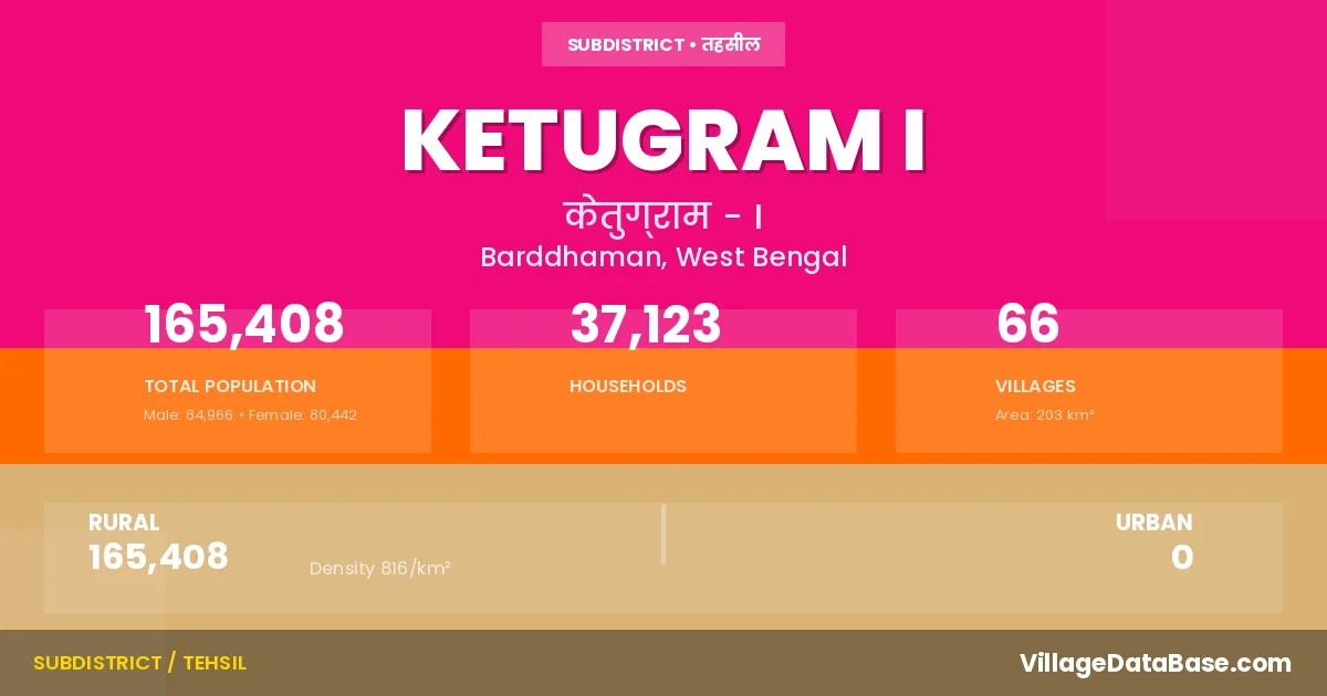
State → West Bengal
Ketugram I is a town and Subdivision in the Barddhaman district of the West Bengal. In India, a Subdivision is a subdivision of a district responsible for the administration and revenue collection of a specific area within the district. Subdivisions play a crucial role in the local governance structure, contributing significantly to the development and administration of their communities.
According to the 2011 census The total area of Ketugram I Subdivision is 203 km², with a population of 165408 people. The population density is 816 inhabitants per square kilometre, and there are approximately 37123 houses in the sub district.
Ketugram I Subdivision comprises about 66 villages. Below is a list of these villages along with information about their respective gram panchayats and the nearest town:
| # | Village Name | Gram Panchayat | Nearest Town |
|---|---|---|---|
| 1 | Agardanga | Agardanga | Katwa (30 km) |
| 2 | Aiyapur Chak | Palita | Ketugram I |
| 3 | Amgaria | Agardanga | Katwa (30 km) |
| 4 | Ankhona | Ankhona | Katura (38 km) |
| 5 | Argun | Rajur | Katwa (36 km) |
| 6 | Bahara | Rajur | Katwa (36 km) |
| 7 | Bakalsa | Pandugram | Katwa (45 km) |
| 8 | Bamundi | Murgram Gopalpur | Katwa (25 km) |
| 9 | Bankui | Palita | Katwa (46 km) |
| 10 | Beninagar | Murgram Gopalpur | Katwa (24 km) |
| 11 | Berugram | Berugram | Katura (36 km) |
| 12 | Bhandargaria | Pandugram | Katwa (42 km) |
| 13 | Bira | Palita | Katwa (45 km) |
| 14 | Biruri | Berugram | Katwa (30 km) |
| 15 | Chakdaha | Pandugram | Katwa (40 km) |
| 16 | Chakta | Ankhona | Katura (46 km) |
| 17 | Chechuri | Ankhona | Katura (40 km) |
| 18 | Chinispur | Berugram | Katura (32 km) |
| 19 | Dadhia | Palita | Katwa (40 km) |
| 20 | Ehiapur | Palita | Katwa (42 km) |
| 21 | Ganful | Pandugram | Katwa (42 km) |
| 22 | Ghatkuri | Pandugram | Katwa (40 km) |
| 23 | Gopalpur | Murgram Gopalpur | Katwa (26 km) |
| 24 | Haldi | Ankhona | Katura (41 km) |
| 25 | Hatpara | Pandugram | Katwa (40 km) |
| 26 | Ichhapur | Ankhona | Katura (40 km) |
| 27 | Jamalpur | Pandugram | Katwa (42 km) |
| 28 | Jamalpur Chak | Pandugram | Ketugram I |
| 29 | Kachutia | Agardanga | Katwa (30 km) |
| 30 | Kanchra | Pandugram | Katwa (34 km) |
| 31 | Kandara | Jyandas Kandara | Katwa (28 km) |
| 32 | Kantadihi | Berugram | Katwa (35 km) |
| 33 | Katandidanga | Murgram Gopalpur | Katwa (21 km) |
| 34 | Kechunia | Agardanga | Katwa (34 km) |
| 35 | Khalipur | Murgram Gopalpur | Katwa (24 km) |
| 36 | Khanji | Rajur | Katwa (31 km) |
| 37 | Khaspur | Rajur | Katwa (40 km) |
| 38 | Khatundi | Pandugram | Katwa (42 km) |
| 39 | Kojalsa | Berugram | Katwa (30 km) |
| 40 | Komarpur | Murgram Gopalpur | Katwa (25 km) |
| 41 | Kulai | Pandugram | Katwa (45 km) |
| 42 | Kulun | Pandugram | Katwa (36 km) |
| 43 | Kulutia | Berugram | Katwa (34 km) |
| 44 | Kurmadanga | Jyandas Kandara | Katwa (33 km) |
| 45 | Kushutia | Ankhona | Katura (40 km) |
| 46 | Mahula | Ankhona | Katura (40 km) |
| 47 | Majhina | Ankhona | Katura (44 km) |
| 48 | Malgram | Agardanga | Katwa (35 km) |
| 49 | Masundi | Rajur | Katwa (36 km) |
| 50 | Mauri | Ankhona | Katura (42 km) |
| 51 | Mitratikuri | Pandugram | Katwa (43 km) |
| 52 | Morgram | Berugram | Katura (36 km) |
| 53 | Murgram | Murgram Gopalpur | Katwa (22 km) |
| 54 | Murutia | Ankhona | Katura (40 km) |
| 55 | Narenga | Palita | Katwa (45 km) |
| 56 | Noapara | Pandugram | Katwa (38 km) |
| 57 | Palita | Palita | Katwa (44 km) |
| 58 | Pandugram | Pandugram | Katwa (42 km) |
| 59 | Panpara | Agardanga | Ketugram I |
| 60 | Panpara Chak | Agardanga | Ketugram I |
| 61 | Raikhan | Rajur | Katwa (32 km) |
| 62 | Rajur | Rajur | Katwa (30 km) |
| 63 | Serandi | Palita | Katwa (42 km) |
| 64 | Shrigram | Agardanga | Katwa (36 km) |
| 65 | Sripur | Jyandas Kandara | Katwa (30 km) |
| 66 | Ujalpur | Jyandas Kandara | Katwa (31 km) |
The population is distributed between urban and rural areas as follows:
| Particulars | Rural | Urban | Total |
|---|---|---|---|
| Total Population | 165408 | 0 | 165408 |
| Male Population | 84966 | 0 | 84966 |
| Female Population | 80442 | 0 | 80442 | Population Density | 816 / km² | 816 / km² |
The distribution of households in the Ketugram I is:
| Rural Households | Urban Households | Total Households |
|---|---|---|
| 37123 | 0 | 37123 |
Q: What is Ketugram I?
A: Ketugram I is a town and in the Barddhaman district of the West Bengal.
Q: What is the total area of Ketugram I Subdivision?
A: The total area of Ketugram I Subdivision is 203 km².
Q: What is the population of Ketugram I Subdivision according to the 2011 census?
A: According to the 2011 census, the population of Ketugram I Subdivision is 165408.
Q: What is the population density of Ketugram I Subdivision?
A: The population density of Ketugram I Subdivision is 816 inhabitants per square kilometre.
Q: How many houses are there in Ketugram I Subdivision?
A: There are approximately 37123 houses in Ketugram I Subdivision.
Q: How many villages are there in Ketugram I Subdivision?
A: There are about 66 villages in Ketugram I Subdivision.
Q: Which is the largest village by population in Ketugram I Subdivision?
A: The largest village by population in Ketugram I Subdivision is Kandara, with 11534 people.
Q: Which is the smallest village by population in Ketugram I Subdivision?
A: The smallest village by population in Ketugram I Subdivision is Aiyapur Chak, with 0 people.
Q: Which is the largest village by area in Ketugram I Subdivision?
A: The largest village by area in Ketugram I Subdivision is Kandara, with 1102 km².
Q: Which is the smallest village by area in Ketugram I Subdivision?
A: The smallest village by area in Ketugram I Subdivision is Jamalpur Chak, with 46 km².
Q: What is the population distribution between urban and rural areas in Ketugram I Subdivision?
A: The population distribution in Ketugram I Subdivision is entirely rural, with a total rural population of 165408.
Q: What is the male population of Ketugram I Subdivision?
A: The male population of Ketugram I Subdivision is 84966.
Q: What is the female population of Ketugram I Subdivision?
A: The female population of Ketugram I Subdivision is 80442.
Q: How is the household distribution in Ketugram I Subdivision?
A: The household distribution in Ketugram I Subdivision is entirely rural, with a total of 37123 households.
Q: How many villages in Ketugram I Subdivision have a population of less than 100?
A: There are 4 villages in Ketugram I Subdivision with a population of less than 100.
Q: How many villages in Ketugram I Subdivision have a population between 100 and 499?
A: There are 6 villages in Ketugram I Subdivision with a population between 100 and 499.
Q: How many villages in Ketugram I Subdivision have a population between 500 and 999?
A: There are 9 villages in Ketugram I Subdivision with a population between 500 and 999.
Q: How many villages in Ketugram I Subdivision have a population between 1000 and 1999?
A: There are 10 villages in Ketugram I Subdivision with a population between 1000 and 1999.
Q: How many villages in Ketugram I Subdivision have a population between 2000 and 2999?
A: There is 15 village in Ketugram I Subdivision with a population between 2000 and 2999.
Q: How many villages in Ketugram I Subdivision have a population between 3000 and 3999?
A: There is 10 village in Ketugram I Subdivision with a population between 3000 and 3999.
Q: How many villages in Ketugram I Subdivision have a population between 4000 and 4999?
A: There is 5 village in Ketugram I Subdivision with a population between 4000 and 4999.
Q: How many villages in Ketugram I Subdivision have a population of 5000 and above?
A: There is 7 village in Ketugram I Subdivision with a population of 5000 and above.
| Total Population | Villages in Sub District Of Ketugram I |
|---|---|
| Less than 100 | 4 |
| 100-499 | 6 |
| 500-999 | 9 |
| 1000-1999 | 10 |
| 2000-2999 | 15 |
| 3000-3999 | 10 |
| 4000-4999 | 5 |
| 5000 And Above | 7 |