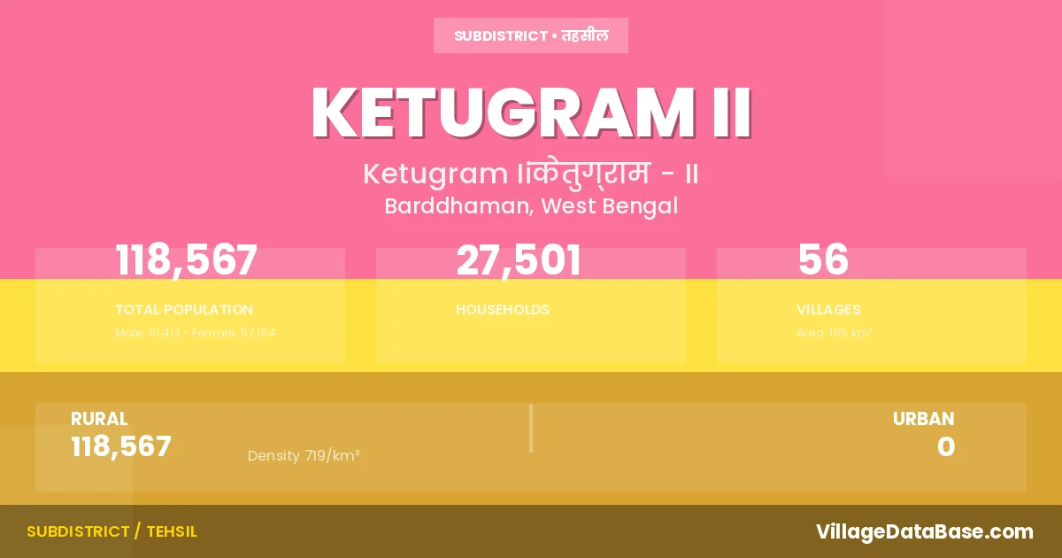
Ketugram II: A Town and Subdivision in Barddhaman district
District → Barddhaman
State → West Bengal
Ketugram II is a town and Subdivision in the Barddhaman district of the West Bengal. In India, a Subdivision is a subdivision of a district responsible for the administration and revenue collection of a specific area within the district. Subdivisions play a crucial role in the local governance structure, contributing significantly to the development and administration of their communities.
According to the 2011 census The total area of Ketugram II Subdivision is 165 km², with a population of 118567 people. The population density is 719 inhabitants per square kilometre, and there are approximately 27501 houses in the sub district.
Ketugram II Subdivision comprises about 56 villages. Below is a list of these villages along with information about their respective gram panchayats and the nearest town:
| # | Village Name | Gram Panchayat | Nearest Town |
|---|---|---|---|
| 1 | Ambalgram | Nabagram | Katwa (10 km) |
| 2 | Anantapur | Gangatikuri | Katwa (15 km) |
| 3 | Baharan | Gangatikuri | Katwa (13 km) |
| 4 | Balutia | Gangatikuri | Katwa (10 km) |
| 5 | Begunkola | Nabagram | Katwa (1 km) |
| 6 | Billeswar Rasui | Billeswar | Katwa (11 km) |
| 7 | Birahimpur | Gangatikuri | Katwa (15 km) |
| 8 | Bishnupur | Maugram | Katwa (10 km) |
| 9 | Brahmadanga | Ketugram | Katwa (3 km) |
| 10 | Chak Kharulia | Nabagram | Katwa (10 km) |
| 11 | Char Narayanpur | Maugram | Ketugram Ii |
| 12 | Char Sujapur | Maugram | Katwa (10 km) |
| 13 | Charkhi | Billeswar | Katwa (2 km) |
| 14 | Chitahati | Billeswar | Katwa (16 km) |
| 15 | Dakshindihi | Ketugram | Katwa (31 km) |
| 16 | Dattabati | Sitahati | Katwa (10 km) |
| 17 | Enayetpur | Sitahati | Katwa (4 km) |
| 18 | Gangatikuri | Gangatikuri | Katwa (10 km) |
| 19 | Gomai | Nabagram | Katwa (3 km) |
| 20 | Gurpara | Billeswar | Katwa (20 km) |
| 21 | Jhamatpur | Gangatikuri | Katwa (15 km) |
| 22 | Kalyanpur | Maugram | Katwa (10 km) |
| 23 | Kamalabari | Maugram | Katwa (10 km) |
| 24 | Kandanag | Ketugram | Katwa (24 km) |
| 25 | Kankurhati | Nabagram | Katwa (5 km) |
| 26 | Kauri | Billeswar | Katwa (17 km) |
| 27 | Ketugram | Ketugram | Katwa (19 km) |
| 28 | Keuguri | Sitahati | Katwa (13 km) |
| 29 | Khenaibanda | Billeswar | Katwa (15 km) |
| 30 | Komdanga | Billeswar | Katwa (12 km) |
| 31 | Kopa | Billeswar | Katwa (12 km) |
| 32 | Loharundi | Ketugram | Katwa (25 km) |
| 33 | Maliha | Billeswar | Katwa (16 km) |
| 34 | Maugram | Maugram | Katwa (10 km) |
| 35 | Murundi | Gangatikuri | Katwa (11 km) |
| 36 | Nabagram | Billeswar | Katwa (5 km) |
| 37 | Naihati | Sitahati | Katwa (7 km) |
| 38 | Naliapur | Sitahati | Katwa (10 km) |
| 39 | Narayanpur | Maugram | Katwa (10 km) |
| 40 | Nirol | Nirol | Katwa (27 km) |
| 41 | Nutangram | Maugram | Katwa (10 km) |
| 42 | Pachandi | Ketugram | Katwa (23 km) |
| 43 | Paschim Sujapur | Sitahati | Katwa (9 km) |
| 44 | Purulia | Nabagram | Katwa (10 km) |
| 45 | Raghupur | Maugram | Katwa (10 km) |
| 46 | Sankhai | Sitahati | Katwa (2 km) |
| 47 | Senpara | Nabagram | Katwa (10 km) |
| 48 | Shiblun | Nabagram | Katwa (5 km) |
| 49 | Shiruli | Sitahati | Katwa (14 km) |
| 50 | Sitahati | Sitahati | Katwa (8 km) |
| 51 | Srirampur | Nirol | Katwa (29 km) |
| 52 | Sujapur | Maugram | Katwa (10 km) |
| 53 | Taipur | Billeswar | Katwa (13 km) |
| 54 | Talari | Nabagram | Katwa' (10 km) |
| 55 | Teora | Billeswar | Katwa (13 km) |
| 56 | Uddharanpur | Sitahati | Katwa (5 km) |
The population is distributed between urban and rural areas as follows:
| Particulars | Rural | Urban | Total |
|---|---|---|---|
| Total Population | 118567 | 0 | 118567 |
| Male Population | 61413 | 0 | 61413 |
| Female Population | 57154 | 0 | 57154 | Population Density | 719 / km² | 719 / km² |
The distribution of households in the Ketugram II is:
| Rural Households | Urban Households | Total Households |
|---|---|---|
| 27501 | 0 | 27501 |
Showing 1 of 1 places
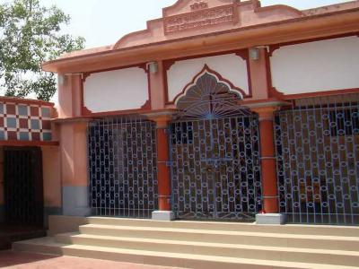
The Bahula Temple, West Benagl | Shakti Peeth is a prominent Temple dedicated to Goddess Shakti located in Ketugram, Ba
Q: What is Ketugram II?
A: Ketugram II is a town and in the Barddhaman district of the West Bengal.
Q: What is the total area of Ketugram II Subdivision?
A: The total area of Ketugram II Subdivision is 165 km².
Q: What is the population of Ketugram II Subdivision according to the 2011 census?
A: According to the 2011 census, the population of Ketugram II Subdivision is 118567.
Q: What is the population density of Ketugram II Subdivision?
A: The population density of Ketugram II Subdivision is 719 inhabitants per square kilometre.
Q: How many houses are there in Ketugram II Subdivision?
A: There are approximately 27501 houses in Ketugram II Subdivision.
Q: How many villages are there in Ketugram II Subdivision?
A: There are about 56 villages in Ketugram II Subdivision.
Q: Which is the largest village by population in Ketugram II Subdivision?
A: The largest village by population in Ketugram II Subdivision is Ketugram, with 9990 people.
Q: Which is the smallest village by population in Ketugram II Subdivision?
A: The smallest village by population in Ketugram II Subdivision is Char Narayanpur, with 0 people.
Q: Which is the largest village by area in Ketugram II Subdivision?
A: The largest village by area in Ketugram II Subdivision is Nabagram, with 882 km².
Q: Which is the smallest village by area in Ketugram II Subdivision?
A: The smallest village by area in Ketugram II Subdivision is Char Narayanpur, with 41 km².
Q: What is the population distribution between urban and rural areas in Ketugram II Subdivision?
A: The population distribution in Ketugram II Subdivision is entirely rural, with a total rural population of 118567.
Q: What is the male population of Ketugram II Subdivision?
A: The male population of Ketugram II Subdivision is 61413.
Q: What is the female population of Ketugram II Subdivision?
A: The female population of Ketugram II Subdivision is 57154.
Q: How is the household distribution in Ketugram II Subdivision?
A: The household distribution in Ketugram II Subdivision is entirely rural, with a total of 27501 households.
Q: How many villages in Ketugram II Subdivision have a population of less than 100?
A: There are 1 villages in Ketugram II Subdivision with a population of less than 100.
Q: How many villages in Ketugram II Subdivision have a population between 100 and 499?
A: There are 5 villages in Ketugram II Subdivision with a population between 100 and 499.
Q: How many villages in Ketugram II Subdivision have a population between 500 and 999?
A: There are 16 villages in Ketugram II Subdivision with a population between 500 and 999.
Q: How many villages in Ketugram II Subdivision have a population between 1000 and 1999?
A: There are 11 villages in Ketugram II Subdivision with a population between 1000 and 1999.
Q: How many villages in Ketugram II Subdivision have a population between 2000 and 2999?
A: There is 9 village in Ketugram II Subdivision with a population between 2000 and 2999.
Q: How many villages in Ketugram II Subdivision have a population between 3000 and 3999?
A: There is 6 village in Ketugram II Subdivision with a population between 3000 and 3999.
Q: How many villages in Ketugram II Subdivision have a population between 4000 and 4999?
A: There is 5 village in Ketugram II Subdivision with a population between 4000 and 4999.
Q: How many villages in Ketugram II Subdivision have a population of 5000 and above?
A: There is 3 village in Ketugram II Subdivision with a population of 5000 and above.
| Total Population | Villages in Sub District Of Ketugram II |
|---|---|
| Less than 100 | 1 |
| 100-499 | 5 |
| 500-999 | 16 |
| 1000-1999 | 11 |
| 2000-2999 | 9 |
| 3000-3999 | 6 |
| 4000-4999 | 5 |
| 5000 And Above | 3 |