Mangolkote: A Town and Subdivision in Barddhaman district
District → Barddhaman
State → West Bengal
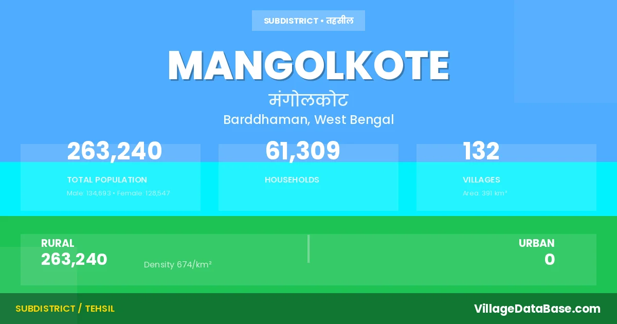
Mangolkote is a town and Subdivision in the Barddhaman district of the West Bengal. In India, a Subdivision is a subdivision of a district responsible for the administration and revenue collection of a specific area within the district. Subdivisions play a crucial role in the local governance structure, contributing significantly to the development and administration of their communities.
According to the 2011 census The total area of Mangolkote Subdivision is 391 km², with a population of 263240 people. The population density is 674 inhabitants per square kilometre, and there are approximately 61309 houses in the sub district.
Mangolkote Subdivision comprises about 132 villages. Below is a list of these villages along with information about their respective gram panchayats and the nearest town:
| # | Village Name | Gram Panchayat | Nearest Town |
|---|---|---|---|
| 1 | Amdob | Lakhuria | Gushkara (10 km) |
| 2 | Aogram | Gotistha | Gushkara (5 km) |
| 3 | Atghara | Lakhuria | Gushkara (20 km) |
| 4 | Babladihi | Jhilu Ii | Katwa (26 km) |
| 5 | Bakulia | Majigram | Katwa (25 km) |
| 6 | Balarampur | Kaichar I | Katwa (10 km) |
| 7 | Balidanga | Chanak | Gushkara (5 km) |
| 8 | Bamunara | Gotistha | Gushkara (5 km) |
| 9 | Bamungram | Kshirgram | Katwa (26 km) |
| 10 | Bankapasi | Kaichar Ii | Katwa (12 km) |
| 11 | Banpara | Jhilu Ii | Katwa (26 km) |
| 12 | Baruipara | Chanak | Gushkara (10 km) |
| 13 | Barulia | Paligram | Gushkara (10 km) |
| 14 | Bebucha | Jhilu I | Katwa (26 km) |
| 15 | Belgram | Nigan | Katwa (22 km) |
| 16 | Bhalugram | Bhalugram | Katwa (20 km) |
| 17 | Bhatpara | Jhilu Ii | Katwa (26 km) |
| 18 | Bhinbhina | Gotistha | Gushkara (10 km) |
| 19 | Brahmapur | Jhilu I | Katwa (27 km) |
| 20 | Buinchi | Bhalugram | Katwa (10 km) |
| 21 | Chaitanyapur | Shimulia I | Katwa (10 km) |
| 22 | Chak Kharija Kshirgram | Kshirgram | Katwa (23 km) |
| 23 | Chak Parag | Chanak | Gushkara (4 km) |
| 24 | Chak Pratappur | Lakhuria | Mangolkote |
| 25 | Chakdaha | Lakhuria | Gushkara (12 km) |
| 26 | Chakulia | Majigram | Katwa (25 km) |
| 27 | Chanak | Chanak | Gushkara (7 km) |
| 28 | Chandra | Gotistha | Gushkara (5 km) |
| 29 | Chhota Poshla | Nigan | Katwa (22 km) |
| 30 | Debagram | Paligram | Gushkara (5 km) |
| 31 | Deulia | Mongalkot | Gushkara (20 km) |
| 32 | Dhanyarukhi | Bhalugram | Katwa (12 km) |
| 33 | Dharsona | Kshirgram | Katwa (25 km) |
| 34 | Durmut | Kaichar Ii | Katwa (10 km) |
| 35 | Dwarshini | Gotistha | Gushkara (10 km) |
| 36 | Gatistha | Gotistha | Gushkara (10 km) |
| 37 | Gobardhanpur | Nigan | Katwa (23 km) |
| 38 | Gobindapur | Chanak | Gushkara (7 km) |
| 39 | Gohagram | Nigan | Katwa (21 km) |
| 40 | Gopalbera | Chanak | Gushkara (5 km) |
| 41 | Halimpur | Jhilu I | Katwa (26 km) |
| 42 | Haripur | Shimulia I | Katwa (10 km) |
| 43 | Ichhabargram | Shimulia Ii | Katwa (28 km) |
| 44 | Ita | Kshirgram | Katwa (24 km) |
| 45 | Jabagram | Kshirgram | Katwa (26 km) |
| 46 | Jagadishpur | Nigan | Katwa (23 km) |
| 47 | Jageswardihi | Kaichar Ii | Katwa (14 km) |
| 48 | Jalpara | Chanak | Gushkara (5 km) |
| 49 | Jartha | Jhilu I | Katwa (25 km) |
| 50 | Jaykrishnapur | Majigram | Katwa (23 km) |
| 51 | Jayrampur | Chanak | Gushkara (7 km) |
| 52 | Jhilera | Lakhuria | Gushkara (12 km) |
| 53 | Jhilu | Jhilu I | Katwa (26 km) |
| 54 | Kaichar | Kaichar I | Katwa (10 km) |
| 55 | Kalaipara | Chanak | Gushkara (5 km) |
| 56 | Kalyanpur | Lakhuria | Gushkara (20 km) |
| 57 | Kanaidanga | Kaichar I | Katwa (10 km) |
| 58 | Kankora | Majigram | Katwa (25 km) |
| 59 | Kashiara | Gotistha | Gushkara (10 km) |
| 60 | Keotsa | Majigram | Katwa (25 km) |
| 61 | Keshabpur | Paligram | Gushkara (5 km) |
| 62 | Kharija Kshirgram | Kshirgram | Katwa (23 km) |
| 63 | Kherua | Bhalugram | Katwa (28 km) |
| 64 | Khudrun | Shimulia Ii | Katwa (26 km) |
| 65 | Khurtuba | Mongalkot | Burdwan (30 km) |
| 66 | Kogram | Lakhuria | Gushkara (20 km) |
| 67 | Konarpur | Majigram | Katwa (22 km) |
| 68 | Kotalghosh | Lakhuria | Gushkara (12 km) |
| 69 | Krishnabati | Shimulia I | Katwa (10 km) |
| 70 | Krishnapur | Chanak | Gushkara (6 km) |
| 71 | Kshirgram | Kshirgram | Katwa (20 km) |
| 72 | Kulsuna | Bhalugram | Katwa (13 km) |
| 73 | Kunda | Jhilu I | Katwa (25 km) |
| 74 | Lakhuria | Lakhuria | Gushkara (12 km) |
| 75 | Lakshmipur | Bhalugram | Katwa (16 km) |
| 76 | Madhpur | Majigram | Katwa (24 km) |
| 77 | Mahartuba | Mongalkot | Burdwan (28 km) |
| 78 | Majigram | Majigram | Katwa (20 km) |
| 79 | Majkhanra | Paligram | Gushkara (12 km) |
| 80 | Maliara | Majigram | Katwa (25 km) |
| 81 | Mallikpur | Chanak | Gushkara (3 km) |
| 82 | Mangalkot | Jhilu I | Katwa (28 km) |
| 83 | Masaru | Nigan | Katwa (23 km) |
| 84 | Mathrun | Shimulia I | Katwa (10 km) |
| 85 | Mukha | Majigram | Katwa (21 km) |
| 86 | Murulia | Kaichar I | Katwa (14 km) |
| 87 | Nabagram | Jhilu I | Mangolkote |
| 88 | Narayanpur | Paligram | Gushkara (12 km) |
| 89 | Nawapara Irsanda | Chanak | Gushkara (10 km) |
| 90 | Nayapara | Gotistha | Gushkara (10 km) |
| 91 | Nigan | Nigan | Katwa (23 km) |
| 92 | Nutanhat | Mongalkot | Gushkara (20 km) |
| 93 | Palashi | Kshirgram | Katwa (28 km) |
| 94 | Paligram | Paligram | Gushkara (10 km) |
| 95 | Palisgram | Shimulia Ii | Katwa (26 km) |
| 96 | Palpara | Chanak | Gushkara (5 km) |
| 97 | Palsona | Nigan | Katwa (25 km) |
| 98 | Paschim Gopalpur | Gotistha | Gushkara (10 km) |
| 99 | Paschim Nabagram | Paligram | Gushkara (5 km) |
| 100 | Pilsoan | Gotistha | Gushkara (5 km) |
| 101 | Pindira | Bhalugram | Katwa (13 km) |
| 102 | Puratan Kurgram | Lakhuria | Gushkara (20 km) |
| 103 | Purbba Gopalpur | Kshirgram | Katwa (25 km) |
| 104 | Purbba Nayapara | Jhilu Ii | Katwa (25 km) |
| 105 | Radhanagar | Gotistha | Gushkara (10 km) |
| 106 | Raghunathpur | Paligram | Gushkara (5 km) |
| 107 | Ramnagar | Chanak | Gushkara (4 km) |
| 108 | Sagira | Lakhuria | Gushkara (20 km) |
| 109 | Sakona | Jhilu Ii | Katwa (27 km) |
| 110 | Salanda | Chanak | Gushkara (5 km) |
| 111 | Sankarpur | Jhilu Ii | Katwa (26 km) |
| 112 | Sanri | Majigram | Katwa (20 km) |
| 113 | Saota | Nigan | Katwa (23 km) |
| 114 | Sarangapur | Chanak | Gushkara (2 km) |
| 115 | Sarulia | Chanak | Gushkara (4 km) |
| 116 | Simulia | Shimulia I | Katwa (10 km) |
| 117 | Singat | Shimulia Ii | Katwa (25 km) |
| 118 | Sinut | Jhilu I | Katwa (25 km) |
| 119 | Sitahati | Lakhuria | Gushkara (20 km) |
| 120 | Sitalgram | Kaichar I | Katwa (10 km) |
| 121 | Siur | Lakhuria | Gushkara (12 km) |
| 122 | Sukhpukuria | Gotistha | Gushkara (5 km) |
| 123 | Syambazar | Bhalugram | Katwa (15 km) |
| 124 | Taldanga | Lakhuria | Gushkara (10 km) |
| 125 | Tantbandi | Paligram | Mangolkote |
| 126 | Thengapara | Jhilu Ii | Katwa (26 km) |
| 127 | Tikuri | Paligram | Gushkara (10 km) |
| 128 | Ujirpur | Chanak | Guskara (5 km) |
| 129 | Uniatatarpur | Paligram | Gushkara (10 km) |
| 130 | Uttar Banpara | Majigram | Katwa (24 km) |
| 131 | Uttar Belgram | Bhalugram | Katwa (12 km) |
| 132 | Uttar Brahmapur | Bhalugram | Katwa (20 km) |
The population is distributed between urban and rural areas as follows:
| Particulars | Rural | Urban | Total |
|---|---|---|---|
| Total Population | 263240 | 0 | 263240 |
| Male Population | 134693 | 0 | 134693 |
| Female Population | 128547 | 0 | 128547 | Population Density | 674 / km² | 674 / km² |
The distribution of households in the Mangolkote is:
| Rural Households | Urban Households | Total Households |
|---|---|---|
| 61309 | 0 | 61309 |
Q: What is Mangolkote?
A: Mangolkote is a town and in the Barddhaman district of the West Bengal.
Q: What is the total area of Mangolkote Subdivision?
A: The total area of Mangolkote Subdivision is 391 km².
Q: What is the population of Mangolkote Subdivision according to the 2011 census?
A: According to the 2011 census, the population of Mangolkote Subdivision is 263240.
Q: What is the population density of Mangolkote Subdivision?
A: The population density of Mangolkote Subdivision is 674 inhabitants per square kilometre.
Q: How many houses are there in Mangolkote Subdivision?
A: There are approximately 61309 houses in Mangolkote Subdivision.
Q: How many villages are there in Mangolkote Subdivision?
A: There are about 132 villages in Mangolkote Subdivision.
Q: Which is the largest village by population in Mangolkote Subdivision?
A: The largest village by population in Mangolkote Subdivision is Mangalkot, with 11537 people.
Q: Which is the smallest village by population in Mangolkote Subdivision?
A: The smallest village by population in Mangolkote Subdivision is Chak Pratappur, with 0 people.
Q: Which is the largest village by area in Mangolkote Subdivision?
A: The largest village by area in Mangolkote Subdivision is Mangalkot, with 1876 km².
Q: Which is the smallest village by area in Mangolkote Subdivision?
A: The smallest village by area in Mangolkote Subdivision is Chak Parag, with 45 km².
Q: What is the population distribution between urban and rural areas in Mangolkote Subdivision?
A: The population distribution in Mangolkote Subdivision is entirely rural, with a total rural population of 263240.
Q: What is the male population of Mangolkote Subdivision?
A: The male population of Mangolkote Subdivision is 134693.
Q: What is the female population of Mangolkote Subdivision?
A: The female population of Mangolkote Subdivision is 128547.
Q: How is the household distribution in Mangolkote Subdivision?
A: The household distribution in Mangolkote Subdivision is entirely rural, with a total of 61309 households.
Q: How many villages in Mangolkote Subdivision have a population of less than 100?
A: There are 4 villages in Mangolkote Subdivision with a population of less than 100.
Q: How many villages in Mangolkote Subdivision have a population between 100 and 499?
A: There are 15 villages in Mangolkote Subdivision with a population between 100 and 499.
Q: How many villages in Mangolkote Subdivision have a population between 500 and 999?
A: There are 25 villages in Mangolkote Subdivision with a population between 500 and 999.
Q: How many villages in Mangolkote Subdivision have a population between 1000 and 1999?
A: There are 40 villages in Mangolkote Subdivision with a population between 1000 and 1999.
Q: How many villages in Mangolkote Subdivision have a population between 2000 and 2999?
A: There is 21 village in Mangolkote Subdivision with a population between 2000 and 2999.
Q: How many villages in Mangolkote Subdivision have a population between 3000 and 3999?
A: There is 13 village in Mangolkote Subdivision with a population between 3000 and 3999.
Q: How many villages in Mangolkote Subdivision have a population between 4000 and 4999?
A: There is 3 village in Mangolkote Subdivision with a population between 4000 and 4999.
Q: How many villages in Mangolkote Subdivision have a population of 5000 and above?
A: There is 11 village in Mangolkote Subdivision with a population of 5000 and above.
| Total Population | Villages in Sub District Of Mangolkote |
|---|---|
| Less than 100 | 4 |
| 100-499 | 15 |
| 500-999 | 25 |
| 1000-1999 | 40 |
| 2000-2999 | 21 |
| 3000-3999 | 13 |
| 4000-4999 | 3 |
| 5000 And Above | 11 |