Rampurhat I: A Town and Subdivision in Birbhum district
District → Birbhum
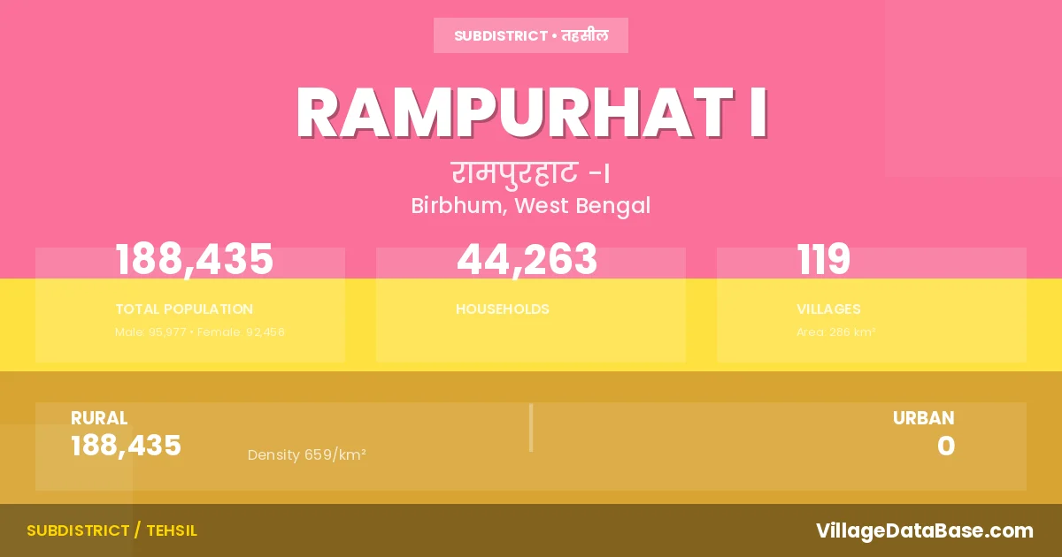
State → West Bengal
Rampurhat I is a town and Subdivision in the Birbhum district of the West Bengal. In India, a Subdivision is a subdivision of a district responsible for the administration and revenue collection of a specific area within the district. Subdivisions play a crucial role in the local governance structure, contributing significantly to the development and administration of their communities.
According to the 2011 census The total area of Rampurhat I Subdivision is 286 km², with a population of 188435 people. The population density is 659 inhabitants per square kilometre, and there are approximately 44263 houses in the sub district.
Rampurhat I Subdivision comprises about 119 villages. Below is a list of these villages along with information about their respective gram panchayats and the nearest town:
| # | Village Name | Gram Panchayat | Nearest Town |
|---|---|---|---|
| 1 | Akhira | Kusumba | Rampurhat (2 km) |
| 2 | Asanjola | Narayanpur | Rampurhat (18 km) |
| 3 | Atla | Kharun | Rampurhat (9 km) |
| 4 | Ayas | Ayas | Rampurhat (9 km) |
| 5 | Badha | Dakhalbati | Rampurhat (4 km) |
| 6 | Bagtui | Barshal | Rampurhat (2 km) |
| 7 | Baidara | Narayanpur | Rampurhat (13 km) |
| 8 | Baikunthapur | Barshal | Rampurhat (6 km) |
| 9 | Balarampur | Kusumba | Rampurhat (6 km) |
| 10 | Balia Mrityunjoypur | Narayanpur | Rampurhat (15 km) |
| 11 | Bamdebpur | Dakhalbati | Rampurhat (8 km) |
| 12 | Bamnigaon | Mashra | Mallarpur (11 km) |
| 13 | Banhat | Bonhat | Rampurhat (6 km) |
| 14 | Baragaon | Mashra | Mallarpur (7 km) |
| 15 | Barshal | Barshal | Rampurhat (5 km) |
| 16 | Bashuipara | Ayas | Rampurhat (10 km) |
| 17 | Batail | Dakhalbati | Rampurhat (4 km) |
| 18 | Belia | Kharun | Rampurhat (6 km) |
| 19 | Bhabki | Dakhalbati | Rampurhat (8 km) |
| 20 | Bhatina | Bonhat | Rampurhat (8 km) |
| 21 | Binodpur | Dakhalbati | Ramourhat (5 km) |
| 22 | Binora | Bonhat | Rampurhat (10 km) |
| 23 | Brahmanigram | Dakhalbati | Rampurhat I |
| 24 | Chakaipur | Kusumba | Rampurhat (8 km) |
| 25 | Chakpara | Kharun | Rampurhat (8 km) |
| 26 | Chandankantha | Barshal | Rampurhat (3 km) |
| 27 | Chandpur | Kusumba | Rampurhat (10 km) |
| 28 | Chhatma Dangal | Kharun | Rampurhat (9 km) |
| 29 | Chhitaspur | Ayas | Rampurhat (5 km) |
| 30 | Chhora | Kusumba | Rampurhat (10 km) |
| 31 | Chhota Kutubpur | Dakhalbati | Rampurhat (5 km) |
| 32 | Chichunri | Kasthogora | Rampurhat (21 km) |
| 33 | Chituri | Bonhat | Rampurhat (10 km) |
| 34 | Dadpur | Ayas | Rampurhat (5 km) |
| 35 | Dakhalbati | Dakhalbati | Rampurhat (4 km) |
| 36 | Dakshin Shibpur | Bonhat | Rampurhat (5 km) |
| 37 | Dangram | Dakhalbati | Rampurhat (5 km) |
| 38 | Debagram | Ayas | Rampurhat (17 km) |
| 39 | Debipur | Bonhat | Rampurhat (6 km) |
| 40 | Dekhuria | Barshal | Rampurhat (9 km) |
| 41 | Dhanmara | Kusumba | Rampurhat (9 km) |
| 42 | Ekpara | Narayanpur | Rampurhat (20 km) |
| 43 | Enta | Dakhalbati | Rampurhat (5 km) |
| 44 | Faridpur | Kharun | Rampurhat (10 km) |
| 45 | Garia | Mashra | Mallarpur (10 km) |
| 46 | Gobindapur | Dakhalbati | Rampurhat (7 km) |
| 47 | Gopalpur | Kasthogora | Rampurhat (21 km) |
| 48 | Gug | Kasthogora | Rampurhat (9 km) |
| 49 | Harioka | Barshal | Rampurhat (5 km) |
| 50 | Hastikanda | Kasthogora | Rampurhat (20 km) |
| 51 | Jagannathpur | Kasthogora | Rampurhat I |
| 52 | Jatla | Kasthogora | Rampurhat (22 km) |
| 53 | Jendur | Bonhat | Rampurhat (5 km) |
| 54 | Joykrishnapur | Dakhalbati | Rampurhat (5 km) |
| 55 | Junidpur | Kharun | Rampurhat (11 km) |
| 56 | Kabilpur | Ayas | Rampurhat (1 km) |
| 57 | Kadasin | Ayas | Rampurhat (6 km) |
| 58 | Kalikapur | Bonhat | Rampurhat (6 km) |
| 59 | Kalisara | Dakhalbati | Rampurhat I |
| 60 | Kamdebpur | Kharun | Rampurhat (9 km) |
| 61 | Kamikhya | Barshal | Rampurhat (6 km) |
| 62 | Kanaipur | Narayanpur | Rampurhat (18 km) |
| 63 | Kanduri | Bonhat | Rampurhat (8 km) |
| 64 | Karkaria | Kharun | Rampurhat (10 km) |
| 65 | Kashtagara | Kasthogora | Rampurhat (22 km) |
| 66 | Kauro | Kharun | Rampurhat (8 km) |
| 67 | Kharun | Kharun | Rampurhat (7 km) |
| 68 | Khedamara | Narayanpur | Rampurhat (22 km) |
| 69 | Khojapur | Mashra | Mallarpur (9 km) |
| 70 | Kumudda | Barshal | Rampurhat (3 km) |
| 71 | Kusumba | Kusumba | Rampurhat (6 km) |
| 72 | Kutigram | Dakhalbati | Rampurhat (11 km) |
| 73 | Kutubpur | Kasthogora | Rampurhat (12 km) |
| 74 | Lakshmibati | Ayas | Nalhati (8 km) |
| 75 | Madhya Gopalpur | Barshal | Rampurhat (5 km) |
| 76 | Magura | Bonhat | Rampurhat (5 km) |
| 77 | Mahendrapur | Dakhalbati | Rampurhat (4 km) |
| 78 | Majkhanda | Barshal | Rampurhat (3 km) |
| 79 | Mallikpur | Ayas | Rampurhat (4 km) |
| 80 | Malsa | Kharun | Rampurhat (10 km) |
| 81 | Mandala | Kusumba | Rampurhat (9 km) |
| 82 | Masanpur | Kasthogora | Rampurhat I |
| 83 | Masra | Mashra | Mallarpur (7 km) |
| 84 | Muradda | Kasthogora | Rampurhat (18 km) |
| 85 | Naishorgram | Narayanpur | Rampurhat (10 km) |
| 86 | Narayanpur | Narayanpur | Rampurhat (16 km) |
| 87 | Nirasia | Mashra | Rampurhat (10 km) |
| 88 | Nischintapur | Kusumba | Rampurhat (1 km) |
| 89 | Palsa | Kharun | Rampurhat (8 km) |
| 90 | Panisail | Ayas | Rampurhat (6 km) |
| 91 | Parkandi | Ayas | Rampurhat (5 km) |
| 92 | Paschim Anantapur | Ayas | Rampurhat (5 km) |
| 93 | Prahladpur | Kasthogora | Rampurhat (23 km) |
| 94 | Purandapur | Mashra | Mallarpur (10 km) |
| 95 | Radipur | Bonhat | Rampurhat (10 km) |
| 96 | Rajkhanda | Kharun | Rampurhat (8 km) |
| 97 | Ramrampur | Kusumba | Rampurhat (1 km) |
| 98 | Rangaipur | Ayas | Nalhati (9 km) |
| 99 | Ranipur | Kasthogora | Rampurhat (22 km) |
| 100 | Sadinpur | Ayas | Rampurhat (8 km) |
| 101 | Saipur | Ayas | Rampurhat (11 km) |
| 102 | Sakirpur | Barshal | Rampurhat (4 km) |
| 103 | Salgaria | Kasthogora | Rampurhat (23 km) |
| 104 | Saonsa | Kasthogora | Rampurhat (19 km) |
| 105 | Sarandhama | Mashra | Rampurhat I |
| 106 | Satgharia | Barshal | Rampurhat (7 km) |
| 107 | Senbandha | Mashra | Suri (48 km) |
| 108 | Serpur | Dakhalbati | Rampurhat (10 km) |
| 109 | Shriharibati | Dakhalbati | Rampurhat (8 km) |
| 110 | Shrikrishnapur Pakhuria | Barshal | Rampurhat (1 km) |
| 111 | Sialdanga | Barshal | Rampurhat I |
| 112 | Sibdaspur | Kusumba | Rampurhat (8 km) |
| 113 | Siura | Kusumba | Rampurhat (8 km) |
| 114 | Sundipur | Kusumba | Rampurhat (1 km) |
| 115 | Tarachua | Mashra | Rampurhat (36 km) |
| 116 | Teldaha | Kasthogora | Rampurhat (17 km) |
| 117 | Tilai | Dakhalbati | Rampurhat (10 km) |
| 118 | Udaypur | Barshal | Rampurhat (10 km) |
| 119 | Uttar Palsa | Ayas | Rampurhat (9 km) |
The population is distributed between urban and rural areas as follows:
| Particulars | Rural | Urban | Total |
|---|---|---|---|
| Total Population | 188435 | 0 | 188435 |
| Male Population | 95977 | 0 | 95977 |
| Female Population | 92458 | 0 | 92458 | Population Density | 659 / km² | 659 / km² |
The distribution of households in the Rampurhat I is:
| Rural Households | Urban Households | Total Households |
|---|---|---|
| 44263 | 0 | 44263 |
Q: What is Rampurhat I?
A: Rampurhat I is a town and in the Birbhum district of the West Bengal.
Q: What is the total area of Rampurhat I Subdivision?
A: The total area of Rampurhat I Subdivision is 286 km².
Q: What is the population of Rampurhat I Subdivision according to the 2011 census?
A: According to the 2011 census, the population of Rampurhat I Subdivision is 188435.
Q: What is the population density of Rampurhat I Subdivision?
A: The population density of Rampurhat I Subdivision is 659 inhabitants per square kilometre.
Q: How many houses are there in Rampurhat I Subdivision?
A: There are approximately 44263 houses in Rampurhat I Subdivision.
Q: How many villages are there in Rampurhat I Subdivision?
A: There are about 119 villages in Rampurhat I Subdivision.
Q: Which is the largest village by population in Rampurhat I Subdivision?
A: The largest village by population in Rampurhat I Subdivision is Balia Mrityunjoypur, with 9717 people.
Q: Which is the smallest village by population in Rampurhat I Subdivision?
A: The smallest village by population in Rampurhat I Subdivision is Jagannathpur, with 0 people.
Q: Which is the largest village by area in Rampurhat I Subdivision?
A: The largest village by area in Rampurhat I Subdivision is Tarachua, with 1707 km².
Q: Which is the smallest village by area in Rampurhat I Subdivision?
A: The smallest village by area in Rampurhat I Subdivision is Sarandhama, with 25 km².
Q: What is the population distribution between urban and rural areas in Rampurhat I Subdivision?
A: The population distribution in Rampurhat I Subdivision is entirely rural, with a total rural population of 188435.
Q: What is the male population of Rampurhat I Subdivision?
A: The male population of Rampurhat I Subdivision is 95977.
Q: What is the female population of Rampurhat I Subdivision?
A: The female population of Rampurhat I Subdivision is 92458.
Q: How is the household distribution in Rampurhat I Subdivision?
A: The household distribution in Rampurhat I Subdivision is entirely rural, with a total of 44263 households.
Q: How many villages in Rampurhat I Subdivision have a population of less than 100?
A: There are 5 villages in Rampurhat I Subdivision with a population of less than 100.
Q: How many villages in Rampurhat I Subdivision have a population between 100 and 499?
A: There are 25 villages in Rampurhat I Subdivision with a population between 100 and 499.
Q: How many villages in Rampurhat I Subdivision have a population between 500 and 999?
A: There are 31 villages in Rampurhat I Subdivision with a population between 500 and 999.
Q: How many villages in Rampurhat I Subdivision have a population between 1000 and 1999?
A: There are 25 villages in Rampurhat I Subdivision with a population between 1000 and 1999.
Q: How many villages in Rampurhat I Subdivision have a population between 2000 and 2999?
A: There is 16 village in Rampurhat I Subdivision with a population between 2000 and 2999.
Q: How many villages in Rampurhat I Subdivision have a population between 3000 and 3999?
A: There is 8 village in Rampurhat I Subdivision with a population between 3000 and 3999.
Q: How many villages in Rampurhat I Subdivision have a population between 4000 and 4999?
A: There is 4 village in Rampurhat I Subdivision with a population between 4000 and 4999.
Q: How many villages in Rampurhat I Subdivision have a population of 5000 and above?
A: There is 5 village in Rampurhat I Subdivision with a population of 5000 and above.
| Total Population | Villages in Sub District Of Rampurhat I |
|---|---|
| Less than 100 | 5 |
| 100-499 | 25 |
| 500-999 | 31 |
| 1000-1999 | 25 |
| 2000-2999 | 16 |
| 3000-3999 | 8 |
| 4000-4999 | 4 |
| 5000 And Above | 5 |