Panchla: A Town and Subdivision in Haora district
District → Haora
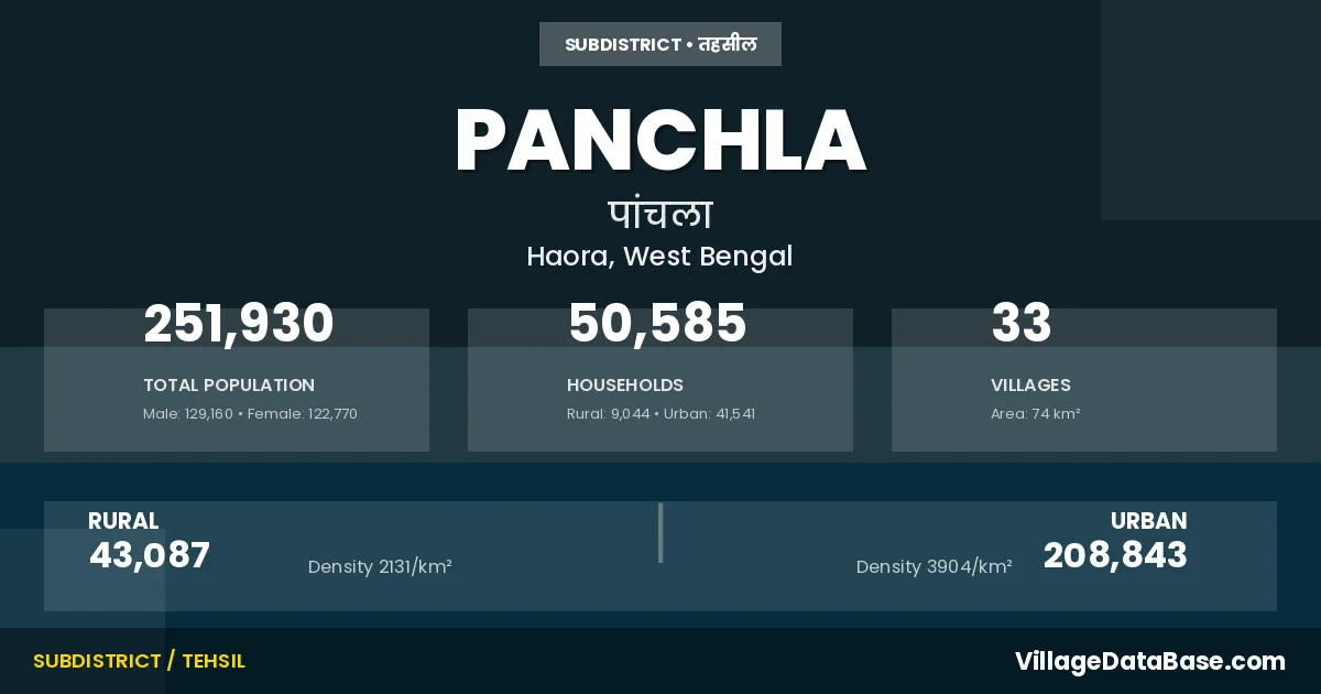
State → West Bengal
Panchla is a town and Subdivision in the Haora district of the West Bengal. In India, a Subdivision is a subdivision of a district responsible for the administration and revenue collection of a specific area within the district. Subdivisions play a crucial role in the local governance structure, contributing significantly to the development and administration of their communities.
According to the 2011 census The total area of Panchla Subdivision is 74 km², with a population of 251930 people. The population density is 3,418 inhabitants per square kilometre, and there are approximately 50585 houses in the sub district.
Panchla Subdivision comprises about 33 villages. Below is a list of these villages along with information about their respective gram panchayats and the nearest town:
| # | Village Name | Gram Panchayat | Nearest Town |
|---|---|---|---|
| 1 | Ban Harishpur | Banharishpur | Panchla |
| 2 | Beldubi | Beldubi | Panchla |
| 3 | Belkulai | Sahapur | Ulberia (20 km) |
| 4 | Bikihakola | Bikihakola | Panchla |
| 5 | Dakshin Panchla | Chara Panchla | Ulberia (15 km) |
| 6 | Deulpur | Deulpur | Panchla |
| 7 | Dhamsa | Sahapur | Ulberia (15 km) |
| 8 | Dhunki | Jalabiswanathpur | Panchla |
| 9 | Gabberia | Jalabiswanathpur | Panchla |
| 10 | Gangadharpur | Gangadharpur | Panchla |
| 11 | Gondalpara | Gangadharpur | Panchla |
| 12 | Jala Bishwanathpur | Jalabiswanathpur | Amta (15 km) |
| 13 | Jala Kendua | Beldubi | Panchla |
| 14 | Jaynagar | Gangadharpur | Panchla |
| 15 | Jayrampur | Deulpur | Andul (7 km) |
| 16 | Jujarsaha | Jujarsaha | Panchla |
| 17 | Khasjalalsi | Gangadharpur | Panchla |
| 18 | Khayjapur | Sahapur | Ulberia (20 km) |
| 19 | Kulai | Beldubi | Andul (15 km) |
| 20 | Kuldanga | Jujarsaha | Panchla |
| 21 | Kusadanga | Deulpur | Panchla |
| 22 | Mallik Bagan | Suvarara | Panchla |
| 23 | Nayachak | Banharishpur | Amta (10 km) |
| 24 | Panchla | Chara Panchla | Panchla |
| 25 | Paniara | Beldubi | Panchla |
| 26 | Paschim Panchla | Chara Panchla | Panchla |
| 27 | Ranihati | Bikihakola | Ulberia (20 km) |
| 28 | Sahapur | Sahapur | Panchla |
| 29 | Samanti | Banharishpur | Amta (10 km) |
| 30 | Sankhali | Bikihakola | Ulberia (20 km) |
| 31 | Satgharia | Sahapur | Andul (12 km) |
| 32 | Shuvararah | Suvarara | Panchla |
| 33 | Shyamchak | Banharishpur | Amta (10 km) |
The population is distributed between urban and rural areas as follows:
| Particulars | Rural | Urban | Total |
|---|---|---|---|
| Total Population | 43087 | 208843 | 251930 |
| Male Population | 22147 | 107013 | 129160 |
| Female Population | 20940 | 101830 | 122770 | Population Density | 2131 / km² | 3904 / km² | 3,418 / km² |
The distribution of households in the Panchla is:
| Rural Households | Urban Households | Total Households |
|---|---|---|
| 9044 | 41541 | 50585 |
Q: What is Panchla?
A: Panchla is a town and in the Haora district of the West Bengal.
Q: What is the total area of Panchla Subdivision?
A: The total area of Panchla Subdivision is 74 km².
Q: What is the population of Panchla Subdivision according to the 2011 census?
A: According to the 2011 census, the population of Panchla Subdivision is 251930.
Q: What is the population density of Panchla Subdivision?
A: The population density of Panchla Subdivision is 3,418 inhabitants per square kilometre.
Q: How many houses are there in Panchla Subdivision?
A: There are approximately 50585 houses in Panchla Subdivision.
Q: How many villages are there in Panchla Subdivision?
A: There are about 33 villages in Panchla Subdivision.
Q: Which is the largest village by population in Panchla Subdivision?
A: The largest village by population in Panchla Subdivision is Jala Bishwanathpur, with 8569 people.
Q: Which is the smallest village by population in Panchla Subdivision?
A: The smallest village by population in Panchla Subdivision is Ban Harishpur, with 0 people.
Q: Which is the largest village by area in Panchla Subdivision?
A: The largest village by area in Panchla Subdivision is Jala Bishwanathpur, with 457 km².
Q: Which is the smallest village by area in Panchla Subdivision?
A: The smallest village by area in Panchla Subdivision is Ban Harishpur, with 0 km².
Q: What is the male population of Panchla Subdivision?
A: The male population of Panchla Subdivision is 129160.
Q: What is the female population of Panchla Subdivision?
A: The female population of Panchla Subdivision is 122770.
Q: How many villages in Panchla Subdivision have a population of less than 100?
A: There are 20 villages in Panchla Subdivision with a population of less than 100.
Q: How many villages in Panchla Subdivision have a population between 100 and 499?
A: There are 2 villages in Panchla Subdivision with a population between 100 and 499.
Q: How many villages in Panchla Subdivision have a population between 2000 and 2999?
A: There is 3 village in Panchla Subdivision with a population between 2000 and 2999.
Q: How many villages in Panchla Subdivision have a population between 3000 and 3999?
A: There is 5 village in Panchla Subdivision with a population between 3000 and 3999.
Q: How many villages in Panchla Subdivision have a population between 4000 and 4999?
A: There is 2 village in Panchla Subdivision with a population between 4000 and 4999.
Q: How many villages in Panchla Subdivision have a population of 5000 and above?
A: There is 1 village in Panchla Subdivision with a population of 5000 and above.
| Total Population | Villages in Sub District Of Panchla |
|---|---|
| Less than 100 | 20 |
| 100-499 | 2 |
| 2000-2999 | 3 |
| 3000-3999 | 5 |
| 4000-4999 | 2 |
| 5000 And Above | 1 |