Sankrail: A Town and Subdivision in Haora district
District → Haora
State → West Bengal
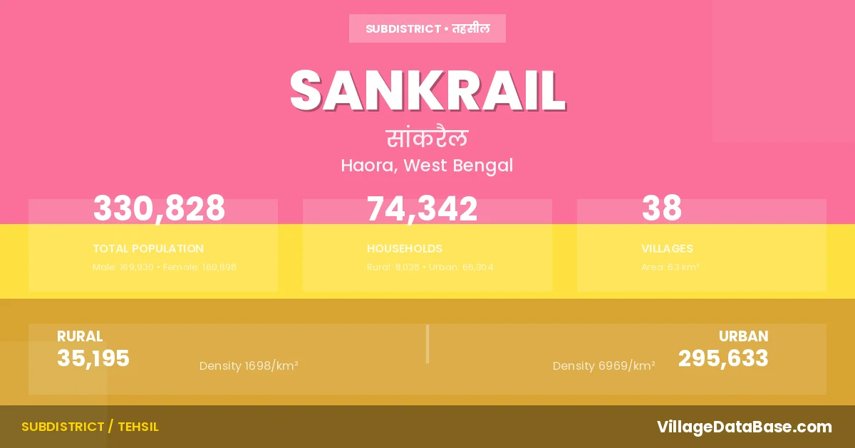
Sankrail is a town and Subdivision in the Haora district of the West Bengal. In India, a Subdivision is a subdivision of a district responsible for the administration and revenue collection of a specific area within the district. Subdivisions play a crucial role in the local governance structure, contributing significantly to the development and administration of their communities.
According to the 2011 census The total area of Sankrail Subdivision is 63 km², with a population of 330828 people. The population density is 5,239 inhabitants per square kilometre, and there are approximately 74342 houses in the sub district.
Sankrail Subdivision comprises about 38 villages. Below is a list of these villages along with information about their respective gram panchayats and the nearest town:
| # | Village Name | Gram Panchayat | Nearest Town |
|---|---|---|---|
| 1 | Alampur | Mashila | Haora (13 km) |
| 2 | Andul | Andul | Sankrail |
| 3 | Argari | Andul | Sankrail |
| 4 | Banupur | Banpur I | Sankrail |
| 5 | Betiari | Nalpur | Uluberia (12 km) |
| 6 | Bhagabatipur | Kandua | Haora (26 km) |
| 7 | Chak Radhadasi | Panchpara | Haora (12 km) |
| 8 | Chak Srikrishna | Raghudebbati | Sankrail |
| 9 | Chatur Bhujkathi | Kandua | Haora (15 km) |
| 10 | Dadpur | Nalpur | Uluberia (12 km) |
| 11 | Dhuilya | Duila | Sankrail |
| 12 | Dhulagari | Dhulagari | Sankrail |
| 13 | Ghoraghat | Dakshin Sankrail | Haora (16 km) |
| 14 | Hatgachha | Bangalpur | Sankrail |
| 15 | Jala Dhulagiri | Dhulagari | Haora (22 km) |
| 16 | Jangalpur | Andul | Haora (11 km) |
| 17 | Jhorhat | Jorhat | Sankrail |
| 18 | Kamranga | Jorhat | Sankrail |
| 19 | Kanyamani | Raghudebbati | Uluberia (13 km) |
| 20 | Kendua | Kandua | Sankrail |
| 21 | Mahishgot | Kandua | Haora (25 km) |
| 22 | Manikpur | Manikpur | Sankrail |
| 23 | Manoharpur | Nalpur | Uluberia (12 km) |
| 24 | Masila | Mashila | Sankrail |
| 25 | Mirjapur | Mashila | Sankrail |
| 26 | Nabghara | Kandua | Sankrail |
| 27 | Nalpur | Nalpur | Sankrail |
| 28 | Osmanpur | Bachhri | Sankrail |
| 29 | Panchpara | Panchpara | Sankrail |
| 30 | Podara | Thanamakua | Sankrail |
| 31 | Raghudebbati | Nalpur | Sankrail |
| 32 | Ramchandrapur | Durgapur Abhaynagar I | Sankrail |
| 33 | Sandhipur | Kandua | Haora (25 km) |
| 34 | Sankrail | Dakshin Sankrail | Sankrail |
| 35 | Sankrailjala | Dakshin Sankrail | Sankrail |
| 36 | Sarenga | Sarenga | Sankrail |
| 37 | Sulati | Kandua | Haora (25 km) |
| 38 | Ula | Nalpur | Sankrail |
The population is distributed between urban and rural areas as follows:
| Particulars | Rural | Urban | Total |
|---|---|---|---|
| Total Population | 35195 | 295633 | 330828 |
| Male Population | 18017 | 151913 | 169930 |
| Female Population | 17178 | 143720 | 160898 | Population Density | 1698 / km² | 6969 / km² | 5,239 / km² |
The distribution of households in the Sankrail is:
| Rural Households | Urban Households | Total Households |
|---|---|---|
| 8038 | 66304 | 74342 |
Q: What is Sankrail?
A: Sankrail is a town and in the Haora district of the West Bengal.
Q: What is the total area of Sankrail Subdivision?
A: The total area of Sankrail Subdivision is 63 km².
Q: What is the population of Sankrail Subdivision according to the 2011 census?
A: According to the 2011 census, the population of Sankrail Subdivision is 330828.
Q: What is the population density of Sankrail Subdivision?
A: The population density of Sankrail Subdivision is 5,239 inhabitants per square kilometre.
Q: How many houses are there in Sankrail Subdivision?
A: There are approximately 74342 houses in Sankrail Subdivision.
Q: How many villages are there in Sankrail Subdivision?
A: There are about 38 villages in Sankrail Subdivision.
Q: Which is the largest village by population in Sankrail Subdivision?
A: The largest village by population in Sankrail Subdivision is Alampur, with 4188 people.
Q: Which is the smallest village by population in Sankrail Subdivision?
A: The smallest village by population in Sankrail Subdivision is Andul, with 0 people.
Q: Which is the largest village by area in Sankrail Subdivision?
A: The largest village by area in Sankrail Subdivision is Jala Dhulagiri, with 371 km².
Q: Which is the smallest village by area in Sankrail Subdivision?
A: The smallest village by area in Sankrail Subdivision is Andul, with 0 km².
Q: What is the male population of Sankrail Subdivision?
A: The male population of Sankrail Subdivision is 169930.
Q: What is the female population of Sankrail Subdivision?
A: The female population of Sankrail Subdivision is 160898.
Q: How many villages in Sankrail Subdivision have a population of less than 100?
A: There are 24 villages in Sankrail Subdivision with a population of less than 100.
Q: How many villages in Sankrail Subdivision have a population between 500 and 999?
A: There are 1 villages in Sankrail Subdivision with a population between 500 and 999.
Q: How many villages in Sankrail Subdivision have a population between 1000 and 1999?
A: There are 4 villages in Sankrail Subdivision with a population between 1000 and 1999.
Q: How many villages in Sankrail Subdivision have a population between 2000 and 2999?
A: There is 4 village in Sankrail Subdivision with a population between 2000 and 2999.
Q: How many villages in Sankrail Subdivision have a population between 3000 and 3999?
A: There is 4 village in Sankrail Subdivision with a population between 3000 and 3999.
Q: How many villages in Sankrail Subdivision have a population between 4000 and 4999?
A: There is 1 village in Sankrail Subdivision with a population between 4000 and 4999.
| Total Population | Villages in Sub District Of Sankrail |
|---|---|
| Less than 100 | 24 |
| 500-999 | 1 |
| 1000-1999 | 4 |
| 2000-2999 | 4 |
| 3000-3999 | 4 |
| 4000-4999 | 1 |