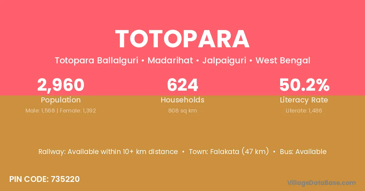
Totopara village is located in the Madarihat Subdivision of the Jalpaiguri district in West Bengal .
Block / Subdivision → Madarihat
District → Jalpaiguri
State → West Bengal
According to Census 2011 information, the village code of Totopara village is 735220.
Totopara village has a total population of 2,960 people, of which 1,568 are males and 1,392 are females.
The literacy rate of Totopara village is 50.20%. Male literacy stands at 59.69% and female literacy at 39.51%.
There are approximately 624 households in Totopara village.
Falakata (47 km) is the nearest town to Totopara village for major economic activities and is located approximately 47 km away.
The population of Totopara village is distributed between literate and illiterate residents as follows:
| Particulars | Male | Female | Total |
|---|---|---|---|
| Literate | 936 | 550 | 1,486 |
| Illiterate | 632 | 842 | 1,474 |
| Total | 1,568 | 1,392 | 2,960 |
Source: Census 2011
| Village | District |
|---|---|
| Ballalguri | Jalpaiguri |
| Dumchi Forest | Jalpaiguri |
| Dumchipara Tea Garden | Jalpaiguri |
| Garganda Tea Garden | Jalpaiguri |
| Hantupara Tea Garden | Jalpaiguri |
| Holapara Forest | Jalpaiguri |
| Madhya Khairbari | Jalpaiguri |
| Mujnai Tea Garden | Jalpaiguri |
| Purba Khairbari | Jalpaiguri |
| Titi Forest | Jalpaiguri |
| Uttar Khairbari | Jalpaiguri |
No reviews yet. Be the first to review this village!
Available within 10+ km distance
Available within village
Available within 5 - 10 km distance