Krishnagar II: A Town and Subdivision in Nadia district
District → Nadia
State → West Bengal
Krishnagar II is a town and Subdivision in the Nadia district of the West Bengal. In India, a Subdivision is a subdivision of a district responsible for the administration and revenue collection of a specific area within the district. Subdivisions play a crucial role in the local governance structure, contributing significantly to the development and administration of their communities.
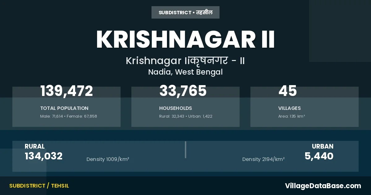
According to the 2011 census The total area of Krishnagar II Subdivision is 135 km², with a population of 139472 people. The population density is 1,031 inhabitants per square kilometre, and there are approximately 33765 houses in the sub district.
Krishnagar II Subdivision comprises about 45 villages. Below is a list of these villages along with information about their respective gram panchayats and the nearest town:
| # | Village Name | Gram Panchayat | Nearest Town |
|---|---|---|---|
| 1 | Armia | Noapara I | Krishnanagar (16 km) |
| 2 | Bahadurpur | Dhubulia Ii | Krishnagar (6 km) |
| 3 | Balainagar | Belpukur | Krishnanagar (30 km) |
| 4 | Bamanpara | Sadhanpara I | Krishnanagar (10 km) |
| 5 | Banagram | Dhubulia I | Krisanagar (12 km) |
| 6 | Bargara | Sadhanpara I | Krishnanagar (10 km) |
| 7 | Belgaon | Dhubulia I | Krishnagar (16 km) |
| 8 | Belpukur | Belpukur | Krishnanagar (17 km) |
| 9 | Bishnu Nagar | Dhubulia Ii | Nabadwip (5 km) |
| 10 | Char Behala | Belpukur | Krishnanagar (23 km) |
| 11 | Charmahatpur | Noapara Ii | Krishnanagar (12 km) |
| 12 | Chaugachhahansadanga | Dhubulia I | Krishnagar (1 km) |
| 13 | Chhagharia | Noapara I | Krishnagar (11 km) |
| 14 | Chuakhali | Noapara Ii | Krishnagar (22 km) |
| 15 | Chupipota | Sadhanpara I | Krishnanagar (10 km) |
| 16 | Dalai Molla | Belpukur | Krishnagar (11 km) |
| 17 | Debipur | Noapara I | Krishnagar (16 km) |
| 18 | Dhubulia | Dhubulia I | Krishnagar (11 km) |
| 19 | Durgabas | Belpukur | Krishnanagar (27 km) |
| 20 | Dwipchandrapur | Belpukur | Krishnanagar (16 km) |
| 21 | Gabarkuli | Sadhanpara Ii | Krishnaanagar (10 km) |
| 22 | Ghateswar | Sadhanpara I | Krishnanagar (10 km) |
| 23 | Harindanga | Noapara I | Krishnagar Ii |
| 24 | Kamarhati | Sadhanpara I | Krishnanagar (10 km) |
| 25 | Kanthaliamath | Belpukur | Krishnagar (13 km) |
| 26 | Khajuri | Sadhanpara I | Krishnanagar (10 km) |
| 27 | Krishna Chandrapur | Dhubulia Ii | Krishnagar (8 km) |
| 28 | Mayaral | Dhubulia Ii | Krishnagar (6 km) |
| 29 | Noapara | Noapara I | Krishnagar (18 km) |
| 30 | Parmedia | Dhubulia Ii | Krishnagar Ii |
| 31 | Paschim Panditpur | Dhubulia I | Krishnagar (21 km) |
| 32 | Pathradaha | Noapara Ii | Krishnagar (16 km) |
| 33 | Polta | Belpukur | Krishnanagar (16 km) |
| 34 | Purbapanditpur | Dhubulia Ii | Krishnagar (7 km) |
| 35 | Rakalgachhi | Sadhanpara I | Krishnanagar (10 km) |
| 36 | Rukunpur | Sadhanpara I | Krishnangar (10 km) |
| 37 | Rupdaha | Noapara Ii | Krishnagar (14 km) |
| 38 | Sadhanpara | Sadhanpara I | Krishnanagar (10 km) |
| 39 | Saheb Nagar | Dhubulia Ii | Krishnagar (8 km) |
| 40 | Singhati | Noapara I | Krishangar (11 km) |
| 41 | Sonadanga | Belpukur | Krishnanagar (16 km) |
| 42 | Sonatala | Noapara Ii | Krishnagar (16 km) |
| 43 | Sujanpur | Sadhanpara Ii | Krishnanagar (10 km) |
| 44 | Tatla | Sadhanpara Ii | Krishnanagar (10 km) |
| 45 | Uttarjhitkipota | Noapara I | Krishnagar (16 km) |
The population is distributed between urban and rural areas as follows:
| Particulars | Rural | Urban | Total |
|---|---|---|---|
| Total Population | 134032 | 5440 | 139472 |
| Male Population | 68826 | 2788 | 71614 |
| Female Population | 65206 | 2652 | 67858 | Population Density | 1009 / km² | 2194 / km² | 1,031 / km² |
The distribution of households in the Krishnagar II is:
| Rural Households | Urban Households | Total Households |
|---|---|---|
| 32343 | 1422 | 33765 |
Q: What is Krishnagar II?
A: Krishnagar II is a town and in the Nadia district of the West Bengal.
Q: What is the total area of Krishnagar II Subdivision?
A: The total area of Krishnagar II Subdivision is 135 km².
Q: What is the population of Krishnagar II Subdivision according to the 2011 census?
A: According to the 2011 census, the population of Krishnagar II Subdivision is 139472.
Q: What is the population density of Krishnagar II Subdivision?
A: The population density of Krishnagar II Subdivision is 1,031 inhabitants per square kilometre.
Q: How many houses are there in Krishnagar II Subdivision?
A: There are approximately 33765 houses in Krishnagar II Subdivision.
Q: How many villages are there in Krishnagar II Subdivision?
A: There are about 45 villages in Krishnagar II Subdivision.
Q: Which is the largest village by population in Krishnagar II Subdivision?
A: The largest village by population in Krishnagar II Subdivision is Dhubulia, with 11623 people.
Q: Which is the smallest village by population in Krishnagar II Subdivision?
A: The smallest village by population in Krishnagar II Subdivision is Harindanga, with 0 people.
Q: Which is the largest village by area in Krishnagar II Subdivision?
A: The largest village by area in Krishnagar II Subdivision is Krishna Chandrapur, with 870 km².
Q: Which is the smallest village by area in Krishnagar II Subdivision?
A: The smallest village by area in Krishnagar II Subdivision is Harindanga, with 0 km².
Q: What is the male population of Krishnagar II Subdivision?
A: The male population of Krishnagar II Subdivision is 71614.
Q: What is the female population of Krishnagar II Subdivision?
A: The female population of Krishnagar II Subdivision is 67858.
Q: How many villages in Krishnagar II Subdivision have a population of less than 100?
A: There are 4 villages in Krishnagar II Subdivision with a population of less than 100.
Q: How many villages in Krishnagar II Subdivision have a population between 100 and 499?
A: There are 1 villages in Krishnagar II Subdivision with a population between 100 and 499.
Q: How many villages in Krishnagar II Subdivision have a population between 500 and 999?
A: There are 3 villages in Krishnagar II Subdivision with a population between 500 and 999.
Q: How many villages in Krishnagar II Subdivision have a population between 1000 and 1999?
A: There are 13 villages in Krishnagar II Subdivision with a population between 1000 and 1999.
Q: How many villages in Krishnagar II Subdivision have a population between 2000 and 2999?
A: There is 9 village in Krishnagar II Subdivision with a population between 2000 and 2999.
Q: How many villages in Krishnagar II Subdivision have a population between 3000 and 3999?
A: There is 3 village in Krishnagar II Subdivision with a population between 3000 and 3999.
Q: How many villages in Krishnagar II Subdivision have a population between 4000 and 4999?
A: There is 5 village in Krishnagar II Subdivision with a population between 4000 and 4999.
Q: How many villages in Krishnagar II Subdivision have a population of 5000 and above?
A: There is 7 village in Krishnagar II Subdivision with a population of 5000 and above.
| Total Population | Villages in Sub District Of Krishnagar II |
|---|---|
| Less than 100 | 4 |
| 100-499 | 1 |
| 500-999 | 3 |
| 1000-1999 | 13 |
| 2000-2999 | 9 |
| 3000-3999 | 3 |
| 4000-4999 | 5 |
| 5000 And Above | 7 |