Basirhat I: A Town and Subdivision in North Twenty Four Parganas district
District → North Twenty Four Parganas
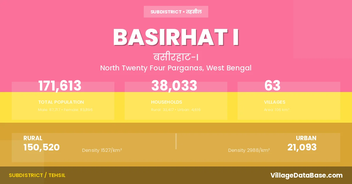
State → West Bengal
Basirhat I is a town and Subdivision in the North Twenty Four Parganas district of the West Bengal. In India, a Subdivision is a subdivision of a district responsible for the administration and revenue collection of a specific area within the district. Subdivisions play a crucial role in the local governance structure, contributing significantly to the development and administration of their communities.
According to the 2011 census The total area of Basirhat I Subdivision is 106 km², with a population of 171613 people. The population density is 1,625 inhabitants per square kilometre, and there are approximately 38033 houses in the sub district.
Basirhat I Subdivision comprises about 63 villages. Below is a list of these villages along with information about their respective gram panchayats and the nearest town:
| # | Village Name | Gram Panchayat | Nearest Town |
|---|---|---|---|
| 1 | Akharpur | Gochha Akharpur | Basirhat (7 km) |
| 2 | Amarkati | Sangrampur Shibhati | Basirhat (5 km) |
| 3 | Anantapur | Gotra | Basirhat (5 km) |
| 4 | Aswathakati | Sangrampur Shibhati | Basirhat (5 km) |
| 5 | Atkaria | Pifa | Basirbat (7 km) |
| 6 | Balipur | Nimdaria Kodalia | Basirhat (10 km) |
| 7 | Bansjhari Mallikpur | Sankchura Begundi | Basirhat (5 km) |
| 8 | Bibidia | Gochha Akharpur | Basirhat (12 km) |
| 9 | Biramnagar | Sangrampur Shibhati | Basirhat (5 km) |
| 10 | Byang Pukuria | Pifa | Basirhat (10 km) |
| 11 | Chak Kamardanga | Sangrampur Shibhati | Basirhat (5 km) |
| 12 | Chaura | Sangrampur Shibhati | Basirhat (5 km) |
| 13 | Dakshin Bagundi | Sankchura Begundi | Taki (4 km) |
| 14 | Dakshin Gulaichandi | Nimdaria Kodalia | Taki (4 km) |
| 15 | Dandirhat | Gotra | Basirhat I |
| 16 | Debhog | Pifa | Basirhat (8 km) |
| 17 | Dhaltitha | Sankchura Begundi | Basirhat (4 km) |
| 18 | Durgapur | Pifa | Basirhat (7 km) |
| 19 | Fatepur | Nimdaria Kodalia | Taki (5 km) |
| 20 | Gachha | Gochha Akharpur | Basirhat (10 km) |
| 21 | Gachharati | Sankchura Begundi | Taki (5 km) |
| 22 | Ghusuri | Nimdaria Kodalia | Basirhat (11 km) |
| 23 | Goalhati | Sankchura Begundi | Basirhat (11 km) |
| 24 | Goknashri Gobindapur | Gotra | Basirhat (10 km) |
| 25 | Gotra | Gotra | Basirhat (10 km) |
| 26 | Gulai Chandi | Nimdaria Kodalia | Basirhat (10 km) |
| 27 | Hariharpur | Sankchura Begundi | Basirhat (10 km) |
| 28 | Itinda | Itinda Panitore | Basirhat I |
| 29 | Jirakpur | Gotra | Basirhat (5 km) |
| 30 | Kathari | Sankchura Begundi | Taki (5 km) |
| 31 | Kathur | Pifa | Basirhat (10 km) |
| 32 | Khidirpore | Pifa | Basirhat (8 km) |
| 33 | Kodalia | Nimdaria Kodalia | Taki (10 km) |
| 34 | Lakshmankati | Gotra | Basirhat (8 km) |
| 35 | Matina | Gotra | Basirhat (6 km) |
| 36 | Merudandi | Sangrampur Shibhati | Basirhat (5 km) |
| 37 | Mukundakati | Gochha Akharpur | Basirhat (8 km) |
| 38 | Nalkora | Sankchura Begundi | Basirhat (4 km) |
| 39 | Nimdari | Nimdaria Kodalia | Taki (10 km) |
| 40 | Nonaghona | Nimdaria Kodalia | Taki (4 km) |
| 41 | Paikardanga | Gochha Akharpur | Basirhat |
| 42 | Paikpara | Pifa | Basirhat (5 km) |
| 43 | Panitar | Itinda Panitore | Basirhat (10 km) |
| 44 | Par Naihati | Sangrampur Shibhati | Basirhat (5 km) |
| 45 | Paschim Madhyampur | Nimdaria Kodalia | Basirhat (1 km) |
| 46 | Patilachandra | Nimdaria Kodalia | Basirhat (10 km) |
| 47 | Pipha | Pifa | Basirhat (7 km) |
| 48 | Prasannakati | Gochha Akharpur | Basirhat (8 km) |
| 49 | Purbba Madhyampur | Sankchura Begundi | Taki (4 km) |
| 50 | Ramnagar | Pifa | Basirhat (5 km) |
| 51 | Rangra | Sangrampur Shibhati | Basirhat I |
| 52 | Sangrampur | Sangrampur Shibhati | Basirhat (5 km) |
| 53 | Sarania | Nimdaria Kodalia | Taki (5 km) |
| 54 | Shankarpur | Nimdaria Kodalia | Taki (5 km) |
| 55 | Shankchura | Sankchura Begundi | Taki (5 km) |
| 56 | Shibhati | Sangrampur Shibhati | Basirhat (5 km) |
| 57 | Shripur | Nimdaria Kodalia | Taki (10 km) |
| 58 | Shwetpur | Pifa | Basirhat (7 km) |
| 59 | Soladana | Sankchura Begundi | Basirhat (4 km) |
| 60 | Subidpur | Pifa | Basirhat (8 km) |
| 61 | Tajpur | Pifa | Basirhat (9 km) |
| 62 | Uttar Bagundi | Gotra | Basirhat I |
| 63 | Zanmamudpur | Pifa | Basirhat (8 km) |
The population is distributed between urban and rural areas as follows:
| Particulars | Rural | Urban | Total |
|---|---|---|---|
| Total Population | 150520 | 21093 | 171613 |
| Male Population | 76930 | 10787 | 87717 |
| Female Population | 73590 | 10306 | 83896 | Population Density | 1527 / km² | 2988 / km² | 1,625 / km² |
The distribution of households in the Basirhat I is:
| Rural Households | Urban Households | Total Households |
|---|---|---|
| 33417 | 4616 | 38033 |
Q: What is Basirhat I?
A: Basirhat I is a town and in the North Twenty Four Parganas district of the West Bengal.
Q: What is the total area of Basirhat I Subdivision?
A: The total area of Basirhat I Subdivision is 106 km².
Q: What is the population of Basirhat I Subdivision according to the 2011 census?
A: According to the 2011 census, the population of Basirhat I Subdivision is 171613.
Q: What is the population density of Basirhat I Subdivision?
A: The population density of Basirhat I Subdivision is 1,625 inhabitants per square kilometre.
Q: How many houses are there in Basirhat I Subdivision?
A: There are approximately 38033 houses in Basirhat I Subdivision.
Q: How many villages are there in Basirhat I Subdivision?
A: There are about 63 villages in Basirhat I Subdivision.
Q: Which is the largest village by population in Basirhat I Subdivision?
A: The largest village by population in Basirhat I Subdivision is Panitar, with 13947 people.
Q: Which is the smallest village by population in Basirhat I Subdivision?
A: The smallest village by population in Basirhat I Subdivision is Dandirhat, with 0 people.
Q: Which is the largest village by area in Basirhat I Subdivision?
A: The largest village by area in Basirhat I Subdivision is Panitar, with 1244 km².
Q: Which is the smallest village by area in Basirhat I Subdivision?
A: The smallest village by area in Basirhat I Subdivision is Dandirhat, with 0 km².
Q: What is the male population of Basirhat I Subdivision?
A: The male population of Basirhat I Subdivision is 87717.
Q: What is the female population of Basirhat I Subdivision?
A: The female population of Basirhat I Subdivision is 83896.
Q: How many villages in Basirhat I Subdivision have a population of less than 100?
A: There are 6 villages in Basirhat I Subdivision with a population of less than 100.
Q: How many villages in Basirhat I Subdivision have a population between 100 and 499?
A: There are 4 villages in Basirhat I Subdivision with a population between 100 and 499.
Q: How many villages in Basirhat I Subdivision have a population between 500 and 999?
A: There are 8 villages in Basirhat I Subdivision with a population between 500 and 999.
Q: How many villages in Basirhat I Subdivision have a population between 1000 and 1999?
A: There are 12 villages in Basirhat I Subdivision with a population between 1000 and 1999.
Q: How many villages in Basirhat I Subdivision have a population between 2000 and 2999?
A: There is 18 village in Basirhat I Subdivision with a population between 2000 and 2999.
Q: How many villages in Basirhat I Subdivision have a population between 3000 and 3999?
A: There is 4 village in Basirhat I Subdivision with a population between 3000 and 3999.
Q: How many villages in Basirhat I Subdivision have a population between 4000 and 4999?
A: There is 4 village in Basirhat I Subdivision with a population between 4000 and 4999.
Q: How many villages in Basirhat I Subdivision have a population of 5000 and above?
A: There is 7 village in Basirhat I Subdivision with a population of 5000 and above.
| Total Population | Villages in Sub District Of Basirhat I |
|---|---|
| Less than 100 | 6 |
| 100-499 | 4 |
| 500-999 | 8 |
| 1000-1999 | 12 |
| 2000-2999 | 18 |
| 3000-3999 | 4 |
| 4000-4999 | 4 |
| 5000 And Above | 7 |