Habra I: A Town and Subdivision in North Twenty Four Parganas district
District → North Twenty Four Parganas
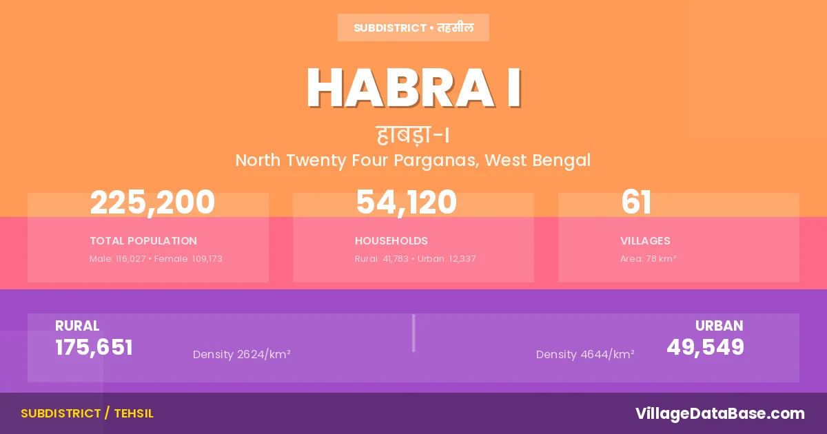
State → West Bengal
Habra I is a town and Subdivision in the North Twenty Four Parganas district of the West Bengal. In India, a Subdivision is a subdivision of a district responsible for the administration and revenue collection of a specific area within the district. Subdivisions play a crucial role in the local governance structure, contributing significantly to the development and administration of their communities.
According to the 2011 census The total area of Habra I Subdivision is 78 km², with a population of 225200 people. The population density is 2,902 inhabitants per square kilometre, and there are approximately 54120 houses in the sub district.
Habra I Subdivision comprises about 61 villages. Below is a list of these villages along with information about their respective gram panchayats and the nearest town:
| # | Village Name | Gram Panchayat | Nearest Town |
|---|---|---|---|
| 1 | Anarbaria | Prithiba | Habra I |
| 2 | Ankhola | Kumra | Habra (13 km) |
| 3 | Arbelia | Prithiba | Ashokenagar (5 km) |
| 4 | Atle | Prithiba | Habra (6 km) |
| 5 | Baluigachhi | Machhlandapur Ii | Habra (8 km) |
| 6 | Bamandanga | Machhlandapur I | Habra (19 km) |
| 7 | Bamhati | Prithiba | Habra (6 km) |
| 8 | Bamhati Raghabpur | Prithiba | Habra (5 km) |
| 9 | Baruihati | Prithiba | Habra (10 km) |
| 10 | Basir Hati | Rautara | Habra (15 km) |
| 11 | Baugachhi | Machhlandapur Ii | Habra (17 km) |
| 12 | Beleni | Bargoom I | Gobordanga |
| 13 | Bergum | Bargum Ii | Habra (9 km) |
| 14 | Betpuli | Machhlandapur I | Habra I |
| 15 | Boyerghata | Kumra | Habra (14 km) |
| 16 | Chakkultala | Prithiba | Habra (8 km) |
| 17 | Dakshin Sarai | Prithiba | Ashokenagar (6 km) |
| 18 | Dariasudi | Rautara | Habra (10 km) |
| 19 | Dhap Dhara | Rautara | Habra (15 km) |
| 20 | Gohalbati | Machhlandapur Ii | Habra (5 km) |
| 21 | Hades Bele | Prithiba | Ashokenagar (10 km) |
| 22 | Hirapol | Prithiba | Habra (5 km) |
| 23 | Ichhapur | Rautara | Habra (17 km) |
| 24 | Janaphul | Bargum Ii | Habra (5 km) |
| 25 | Jashur | Prithiba | Habra (6 km) |
| 26 | Jhanjhania | Bargoom I | Gobordanga (4 km) |
| 27 | Jioldanga | Prithiba | Habra (7 km) |
| 28 | Kashipur | Kumra | Habra (10 km) |
| 29 | Kharo | Kumra | Habra (10 km) |
| 30 | Kola | Rautara | Habra (16 km) |
| 31 | Krishna Nagar | Bargum Ii | Habra (11 km) |
| 32 | Kuchlia | Bargoom I | Gobordanga (3 km) |
| 33 | Kultala | Prithiba | Habra (10 km) |
| 34 | Kumra | Kumra | Habra (11 km) |
| 35 | Lakshmipul | Rautara | Habra (11 km) |
| 36 | Mahisha Machhlandapur | Kumra | Habra (8 km) |
| 37 | Maligram | Rautara | Habra (18 km) |
| 38 | Mallickpur | Bargoom I | Gobordanga (3 km) |
| 39 | Marakpur | Prithiba | Habra (14 km) |
| 40 | Maslandapur | Machhlandapur I | Habra I |
| 41 | Mathurapur | Rautara | Habra (8 km) |
| 42 | Metiagachi | Bargoom I | Gobordanga (3 km) |
| 43 | Nangla | Machhlandapur Ii | Habra (13 km) |
| 44 | Nokpul | Bargoom I | Habra I |
| 45 | Panchghara | Kumra | Habra (12 km) |
| 46 | Payragachhi | Bargum Ii | Habra (8 km) |
| 47 | Phultala | Machhlandapur Ii | Habra (8 km) |
| 48 | Prithiba | Prithiba | Habra (14 km) |
| 49 | Purbba Narayanpur | Rautara | Habra I |
| 50 | Raghabpur | Machhlandapur I | Habra (17 km) |
| 51 | Rajballabhpur | Machhlandapur Ii | Habra (14 km) |
| 52 | Ranidanga | Machhlandapur I | Habra (18 km) |
| 53 | Rautara | Rautara | Habra (14 km) |
| 54 | Rudrapur | Kumra | Habra (7 km) |
| 55 | Sadpur | Machhlandapur I | Habra I |
| 56 | Saltia | Machhlandapur Ii | Habra (4 km) |
| 57 | Salua | Machhlandapur Ii | Habra (12 km) |
| 58 | Simulpur | Machhlandapur Ii | Habra (13 km) |
| 59 | Sonakene | Kumra | Habra (12 km) |
| 60 | Tunighata | Kumra | Habra (9 km) |
| 61 | Uludanga | Machhlandapur I | Habra (16 km) |
The population is distributed between urban and rural areas as follows:
| Particulars | Rural | Urban | Total |
|---|---|---|---|
| Total Population | 175651 | 49549 | 225200 |
| Male Population | 90735 | 25292 | 116027 |
| Female Population | 84916 | 24257 | 109173 | Population Density | 2624 / km² | 4644 / km² | 2,902 / km² |
The distribution of households in the Habra I is:
| Rural Households | Urban Households | Total Households |
|---|---|---|
| 41783 | 12337 | 54120 |
Q: What is Habra I?
A: Habra I is a town and in the North Twenty Four Parganas district of the West Bengal.
Q: What is the total area of Habra I Subdivision?
A: The total area of Habra I Subdivision is 78 km².
Q: What is the population of Habra I Subdivision according to the 2011 census?
A: According to the 2011 census, the population of Habra I Subdivision is 225200.
Q: What is the population density of Habra I Subdivision?
A: The population density of Habra I Subdivision is 2,902 inhabitants per square kilometre.
Q: How many houses are there in Habra I Subdivision?
A: There are approximately 54120 houses in Habra I Subdivision.
Q: How many villages are there in Habra I Subdivision?
A: There are about 61 villages in Habra I Subdivision.
Q: Which is the largest village by population in Habra I Subdivision?
A: The largest village by population in Habra I Subdivision is Janaphul, with 9515 people.
Q: Which is the smallest village by population in Habra I Subdivision?
A: The smallest village by population in Habra I Subdivision is Anarbaria, with 0 people.
Q: Which is the largest village by area in Habra I Subdivision?
A: The largest village by area in Habra I Subdivision is Sonakene, with 647 km².
Q: Which is the smallest village by area in Habra I Subdivision?
A: The smallest village by area in Habra I Subdivision is Anarbaria, with 0 km².
Q: What is the male population of Habra I Subdivision?
A: The male population of Habra I Subdivision is 116027.
Q: What is the female population of Habra I Subdivision?
A: The female population of Habra I Subdivision is 109173.
Q: How many villages in Habra I Subdivision have a population of less than 100?
A: There are 6 villages in Habra I Subdivision with a population of less than 100.
Q: How many villages in Habra I Subdivision have a population between 1000 and 1999?
A: There are 14 villages in Habra I Subdivision with a population between 1000 and 1999.
Q: How many villages in Habra I Subdivision have a population between 2000 and 2999?
A: There is 20 village in Habra I Subdivision with a population between 2000 and 2999.
Q: How many villages in Habra I Subdivision have a population between 3000 and 3999?
A: There is 8 village in Habra I Subdivision with a population between 3000 and 3999.
Q: How many villages in Habra I Subdivision have a population between 4000 and 4999?
A: There is 2 village in Habra I Subdivision with a population between 4000 and 4999.
Q: How many villages in Habra I Subdivision have a population of 5000 and above?
A: There is 11 village in Habra I Subdivision with a population of 5000 and above.
| Total Population | Villages in Sub District Of Habra I |
|---|---|
| Less than 100 | 6 |
| 1000-1999 | 14 |
| 2000-2999 | 20 |
| 3000-3999 | 8 |
| 4000-4999 | 2 |
| 5000 And Above | 11 |