Daspur II: A Town and Subdivision in Paschim Medinipur district
District → Paschim Medinipur
State → West Bengal
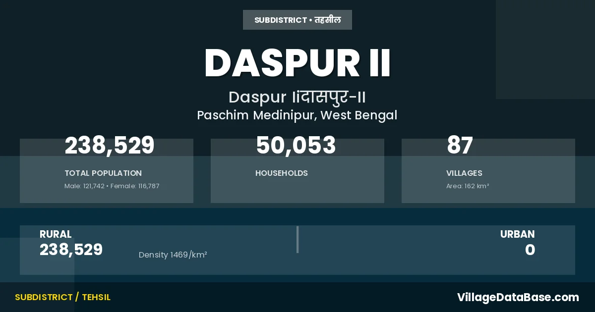
Daspur II is a town and Subdivision in the Paschim Medinipur district of the West Bengal. In India, a Subdivision is a subdivision of a district responsible for the administration and revenue collection of a specific area within the district. Subdivisions play a crucial role in the local governance structure, contributing significantly to the development and administration of their communities.
According to the 2011 census The total area of Daspur II Subdivision is 162 km², with a population of 238529 people. The population density is 1,469 inhabitants per square kilometre, and there are approximately 50053 houses in the sub district.
Daspur II Subdivision comprises about 87 villages. Below is a list of these villages along with information about their respective gram panchayats and the nearest town:
| # | Village Name | Gram Panchayat | Nearest Town |
|---|---|---|---|
| 1 | Adampur | Nishchintapur | Ghatal (10 km) |
| 2 | Ajurya | Palashpai | Ghatal (10 km) |
| 3 | Alipur | Kheputdakshnibarh | Ghatal (10 km) |
| 4 | Arit | Benai | Ghatal (10 km) |
| 5 | Benai | Benai | Ghatal (10 km) |
| 6 | Bhagaban Chak | Palashpai | Ghatal (10 km) |
| 7 | Bhagabatipur | Kamalpur | Ghatal (10 km) |
| 8 | Bhuta | Sahachak | Ghatal (10 km) |
| 9 | Bhuyanra | Benai | Ghatal (10 km) |
| 10 | Bishnupur | Sahachak | Ghatal (10 km) |
| 11 | Chak Dogachhia | Dudhkomra | Ghatal (10 km) |
| 12 | Chak Kishor | Gochhati | Ghatal (10 km) |
| 13 | Chak Madaria | Dudhkomra | Ghatal (10 km) |
| 14 | Chak Sultan | Gochhati | Ghatal (10 km) |
| 15 | Chanipat | Chaipat | Ghatal (10 km) |
| 16 | Dakshin Bar | Kheputdakshnibarh | Ghatal (10 km) |
| 17 | Dangabhanga | Jyotghanashyam | Ghatal (10 km) |
| 18 | Dari Ajodhya | Ranichak | Ghatal (10 km) |
| 19 | Dubrajpur | Khanjapur | Ghatal (10 km) |
| 20 | Dudhkonara | Dudhkomra | Ghatal (10 km) |
| 21 | Faridpur | Nishchintapur | Ghatal (10 km) |
| 22 | Garurna | Goura | Ghatal (10 km) |
| 23 | Gauri Chak | Jyotghanashyam | Ghatal (10 km) |
| 24 | Ghanashyambati | Sahachak | Ghatal (10 km) |
| 25 | Gomakpota | Jyotghanashyam | Kolaghat (10 km) |
| 26 | Gopalpur | Khanjapur | Ghatal (10 km) |
| 27 | Guchhati | Gochhati | Ghatal (10 km) |
| 28 | Hajraberya | Khanjapur | Ghatal (10 km) |
| 29 | Isabpur | Khanjapur | Ghatal (10 km) |
| 30 | Jagannathpur | Khukurdaha | Ghatal (10 km) |
| 31 | Jajpur | Gochhati | Ghatal (10 km) |
| 32 | Jayram Chak | Palashpai | Ghatal (10 km) |
| 33 | Jayrampur | Palashpai | Ghatal (10 km) |
| 34 | Jot Bhagaban | Gochhati | Ghatal (10 km) |
| 35 | Jot Ghanashyam | Jyotghanashyam | Ghatal (10 km) |
| 36 | Jot Gobardhan | Gochhati | Ghatal (20 km) |
| 37 | Jot Kanusamgar | Kamalpur | Ghatal (10 km) |
| 38 | Jot Keshab | Palashpai | Ghatal (10 km) |
| 39 | Jotmaniram | Kamalpur | Ghatal (10 km) |
| 40 | Juakhali | Gochhati | Ghatal (10 km) |
| 41 | Kaigerya | Khanjapur | Ghatal (10 km) |
| 42 | Kaijuri | Benai | Ghatal (10 km) |
| 43 | Kala Gechhya | Khanjapur | Ghatal (10 km) |
| 44 | Kamalpur | Kamalpur | Ghatal (10 km) |
| 45 | Kashinathpur | Khukurdaha | Ghatal (10 km) |
| 46 | Kashiyara | Dudhkomra | Ghatal (10 km) |
| 47 | Kelegoda | Gochhati | Ghatal (10 km) |
| 48 | Khanjapur | Khanjapur | Ghatal (10 km) |
| 49 | Khash Chak | Khukurdaha | Panskura (10 km) |
| 50 | Khudi Chak | Kamalpur | Ghatal (10 km) |
| 51 | Khukur Daha | Khukurdaha | Panskura (10 km) |
| 52 | Kismatsayla | Sahachak | Ghatal (10 km) |
| 53 | Kucha Mari | Khukurdaha | Panskura (10 km) |
| 54 | Kultikri | Dudhkomra | Ghatal (10 km) |
| 55 | Lakshman Chak | Goura | Ghatal (10 km) |
| 56 | Lakshya Kundu | Khukurdaha | Ghatal (10 km) |
| 57 | Maguria | Dudhkomra | Ghatal |
| 58 | Mahakal Pota | Sahachak | Ghatal (10 km) |
| 59 | Mahishghata | Kheputdakshnibarh | Ghatal (10 km) |
| 60 | Manikdipa | Kheputdakshnibarh | Ghatal (10 km) |
| 61 | Nabin Manua | Goura | Ghatal (10 km) |
| 62 | Naihati | Benai | Ghatal (10 km) |
| 63 | Narayan Chak | Jyotghanashyam | Ghatal (10 km) |
| 64 | Nischintapur | Nishchintapur | Ghatal (25 km) |
| 65 | Nonanarayan Chak | Jyotghanashyam | Ghatal (10 km) |
| 66 | Palashpai | Palashpai | Ghatal (10 km) |
| 67 | Panch Gechhia Part I | Nishchintapur | Ghatal (25 km) |
| 68 | Panch Gechhia Part Ii | Nishchintapur | Panskura (21 km) |
| 69 | Radha Ballabh Chak | Khukurdaha | Ghatal (10 km) |
| 70 | Ramkrishnapur | Kamalpur | Ghatal (10 km) |
| 71 | Ramnagar | Khanjapur | Ghatal (10 km) |
| 72 | Rampur | Goura | Ghatal (10 km) |
| 73 | Rana | Gochhati | Ghatal (10 km) |
| 74 | Ranichak | Ranichak | Ghatal (10 km) |
| 75 | Sahachak | Sahachak | Ghatal (10 km) |
| 76 | Salya | Sahachak | Ghatal (10 km) |
| 77 | Satpota | Jyotghanashyam | Ghatal (10 km) |
| 78 | Shripur | Khukurdaha | Panskura (10 km) |
| 79 | Shyam Chak | Goura | Ghatal (10 km) |
| 80 | Singhachak | Gochhati | Ghatal (10 km) |
| 81 | Sitapur | Goura | Ghatal (10 km) |
| 82 | Sona Khali | Gochhati | Ghatal (10 km) |
| 83 | Sonamui | Goura | Ghatal (10 km) |
| 84 | Sribara | Dudhkomra | Ghatal (10 km) |
| 85 | Sriramnagar | Khanjapur | Ghatal (10 km) |
| 86 | Udaychak | Sahachak | Ghatal (10 km) |
| 87 | Uttar Bar | Kheputdakshnibarh | Ghatal (10 km) |
The population is distributed between urban and rural areas as follows:
| Particulars | Rural | Urban | Total |
|---|---|---|---|
| Total Population | 238529 | 0 | 238529 |
| Male Population | 121742 | 0 | 121742 |
| Female Population | 116787 | 0 | 116787 | Population Density | 1469 / km² | 1,469 / km² |
The distribution of households in the Daspur II is:
| Rural Households | Urban Households | Total Households |
|---|---|---|
| 50053 | 0 | 50053 |
Q: What is Daspur II?
A: Daspur II is a town and in the Paschim Medinipur district of the West Bengal.
Q: What is the total area of Daspur II Subdivision?
A: The total area of Daspur II Subdivision is 162 km².
Q: What is the population of Daspur II Subdivision according to the 2011 census?
A: According to the 2011 census, the population of Daspur II Subdivision is 238529.
Q: What is the population density of Daspur II Subdivision?
A: The population density of Daspur II Subdivision is 1,469 inhabitants per square kilometre.
Q: How many houses are there in Daspur II Subdivision?
A: There are approximately 50053 houses in Daspur II Subdivision.
Q: How many villages are there in Daspur II Subdivision?
A: There are about 87 villages in Daspur II Subdivision.
Q: Which is the largest village by population in Daspur II Subdivision?
A: The largest village by population in Daspur II Subdivision is Chanipat, with 16345 people.
Q: Which is the smallest village by population in Daspur II Subdivision?
A: The smallest village by population in Daspur II Subdivision is Kucha Mari, with 144 people.
Q: Which is the largest village by area in Daspur II Subdivision?
A: The largest village by area in Daspur II Subdivision is Chanipat, with 1043 km².
Q: Which is the smallest village by area in Daspur II Subdivision?
A: The smallest village by area in Daspur II Subdivision is Nonanarayan Chak, with 17 km².
Q: What is the population distribution between urban and rural areas in Daspur II Subdivision?
A: The population distribution in Daspur II Subdivision is entirely rural, with a total rural population of 238529.
Q: What is the male population of Daspur II Subdivision?
A: The male population of Daspur II Subdivision is 121742.
Q: What is the female population of Daspur II Subdivision?
A: The female population of Daspur II Subdivision is 116787.
Q: How is the household distribution in Daspur II Subdivision?
A: The household distribution in Daspur II Subdivision is entirely rural, with a total of 50053 households.
Q: How many villages in Daspur II Subdivision have a population between 100 and 499?
A: There are 7 villages in Daspur II Subdivision with a population between 100 and 499.
Q: How many villages in Daspur II Subdivision have a population between 500 and 999?
A: There are 11 villages in Daspur II Subdivision with a population between 500 and 999.
Q: How many villages in Daspur II Subdivision have a population between 1000 and 1999?
A: There are 23 villages in Daspur II Subdivision with a population between 1000 and 1999.
Q: How many villages in Daspur II Subdivision have a population between 2000 and 2999?
A: There is 18 village in Daspur II Subdivision with a population between 2000 and 2999.
Q: How many villages in Daspur II Subdivision have a population between 3000 and 3999?
A: There is 10 village in Daspur II Subdivision with a population between 3000 and 3999.
Q: How many villages in Daspur II Subdivision have a population between 4000 and 4999?
A: There is 8 village in Daspur II Subdivision with a population between 4000 and 4999.
Q: How many villages in Daspur II Subdivision have a population of 5000 and above?
A: There is 10 village in Daspur II Subdivision with a population of 5000 and above.
| Total Population | Villages in Sub District Of Daspur II |
|---|---|
| 100-499 | 7 |
| 500-999 | 11 |
| 1000-1999 | 23 |
| 2000-2999 | 18 |
| 3000-3999 | 10 |
| 4000-4999 | 8 |
| 5000 And Above | 10 |