Bhangar II: A Town and Subdivision in South Twenty Four Parganas district
District → South Twenty Four Parganas
State → West Bengal
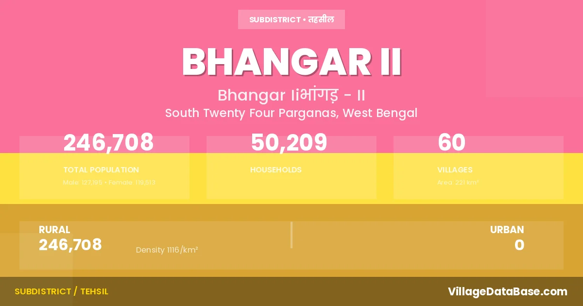
Bhangar II is a town and Subdivision in the South Twenty Four Parganas district of the West Bengal. In India, a Subdivision is a subdivision of a district responsible for the administration and revenue collection of a specific area within the district. Subdivisions play a crucial role in the local governance structure, contributing significantly to the development and administration of their communities.
According to the 2011 census The total area of Bhangar II Subdivision is 221 km², with a population of 246708 people. The population density is 1,116 inhabitants per square kilometre, and there are approximately 50209 houses in the sub district.
Bhangar II Subdivision comprises about 60 villages. Below is a list of these villages along with information about their respective gram panchayats and the nearest town:
| # | Village Name | Gram Panchayat | Nearest Town |
|---|---|---|---|
| 1 | Abua | Bhagawanpur | Dum Dum (21 km) |
| 2 | Anantapur | Polerhat I | Dum Dum (20 km) |
| 3 | Bamunia | Chaltaberia | Saltlake (25 km) |
| 4 | Baniara | Bhogali Ii | Dum Dum (32 km) |
| 5 | Bankachua | Bhogali Ii | Dum Dum (32 km) |
| 6 | Benota | Beenta I | Saltlake (14 km) |
| 7 | Bhaga Banpur | Bhagawanpur | Dum Dum (10 km) |
| 8 | Bhogali | Bhogali I | Dum Dum (30 km) |
| 9 | Chak Maricha | Chaltaberia | Dum Dum (30 km) |
| 10 | Chalta Beria | Chaltaberia | Dum Dum (40 km) |
| 11 | Chandakanthal Beria | Beenta Ii | Saltlake (20 km) |
| 12 | Chandi Hat | Shanpukur | Dum Dum (30 km) |
| 13 | Chariswar | Beenta I | Sealdaha (10 km) |
| 14 | Chilatala | Bhogali Ii | Dum Dum (32 km) |
| 15 | Dakshin Khayerpur | Bhagawanpur | Dum Dum (22 km) |
| 16 | Dakshin Swarup Nagar | Polerhat Ii | Dum Dum (20 km) |
| 17 | Dhapa Manpur | Bamanghata | Bhangar Ii |
| 18 | Dharmatala Pachuria | Beenta Ii | Saltlake (16 km) |
| 19 | Dheati | Shanpukur | Dum Dum (30 km) |
| 20 | Gara Gachha | Shanpukur | Dum Dum (30 km) |
| 21 | Hadia | Bamanghata | Saltlake (12 km) |
| 22 | Hat Gachha | Bamanghata | Saltlake (8 km) |
| 23 | Hatisala | Beenta Ii | Saltlake (16 km) |
| 24 | Jamirgachhi | Bhogali I | Dum Dum (30 km) |
| 25 | Jawpur | Chaltaberia | Dum Dum (30 km) |
| 26 | Jaynagar | Polerhat I | Dum Dum (20 km) |
| 27 | Jiran Gachhi | Bhagawanpur | Dum Dum (28 km) |
| 28 | Jot Bhim | Bamanghata | Saltlake (12 km) |
| 29 | Kachua | Chaltaberia | Dum Dum (34 km) |
| 30 | Kantadanga | Bhogali Ii | Dum Dum (32 km) |
| 31 | Koch Pukur | Bamanghata | Saltlake (10 km) |
| 32 | Krolbaria | Beenta I | Saltlake (16 km) |
| 33 | Kulberia | Beenta Ii | Saltlake (18 km) |
| 34 | Majerhat | Shanpukur | Dum Dum (28 km) |
| 35 | Nangalbeki | Bhagawanpur | Dum Dum (32 km) |
| 36 | Nangla Palpur | Bhogali I | Dum Dum (30 km) |
| 37 | Naoabad | Polerhat I | Dum Dum (17 km) |
| 38 | Nimkuria | Shanpukur | Dum Dum (32 km) |
| 39 | Paikan | Beenta Ii | Dum Dum (20 km) |
| 40 | Panapukur | Chaltaberia | Dum Dum (32 km) |
| 41 | Pitha Pukuria | Bhagawanpur | Bhangar Ii |
| 42 | Raghunathpur | Bhogali I | Dum Dum (24 km) |
| 43 | Rampur | Shanpukur | Dum Dum (27 km) |
| 44 | Saduli | Bhagawanpur | Dum Dum (32 km) |
| 45 | Sanpukuria | Shanpukur | Dum Dum (32 km) |
| 46 | Sat Bhaiya | Bhogali I | Dum Dum (30 km) |
| 47 | Shyamnagar | Polerhat Ii | Dum Dum (18 km) |
| 48 | Sonpur | Shanpukur | Dum Dum (26 km) |
| 49 | Suk Pukuria | Beenta I | Saltlake (15 km) |
| 50 | Swastayan Gachhi | Polerhat I | Dum Dum (17 km) |
| 51 | Tara Hadia | Bhagawanpur | Dum Dum (22 km) |
| 52 | Tona | Polerhat Ii | Bhangar Ii |
| 53 | Uriaparaur | Polerhat Ii | Dum Dum (20 km) |
| 54 | Uttar Gazipur | Polerhat Ii | Dum Dum (20 km) |
| 55 | Uttar Kasipur | Shanpukur | Dum Dum (24 km) |
| 56 | Uttar Kathalia | Bhogali Ii | Dum Dum (32 km) |
| 57 | Uttar Narikel Beria | Bhagawanpur | Dum Dum (30 km) |
| 58 | Uttar Rajapur | Shanpukur | Dum Dum (30 km) |
| 59 | Uttar Swarup Nagar | Polerhat Ii | Dum Dum (20 km) |
| 60 | Wari | Beenta Ii | Dum Dum (25 km) |
The population is distributed between urban and rural areas as follows:
| Particulars | Rural | Urban | Total |
|---|---|---|---|
| Total Population | 246708 | 0 | 246708 |
| Male Population | 127195 | 0 | 127195 |
| Female Population | 119513 | 0 | 119513 | Population Density | 1116 / km² | 1,116 / km² |
The distribution of households in the Bhangar II is:
| Rural Households | Urban Households | Total Households |
|---|---|---|
| 50209 | 0 | 50209 |
Q: What is Bhangar II?
A: Bhangar II is a town and in the South Twenty Four Parganas district of the West Bengal.
Q: What is the total area of Bhangar II Subdivision?
A: The total area of Bhangar II Subdivision is 221 km².
Q: What is the population of Bhangar II Subdivision according to the 2011 census?
A: According to the 2011 census, the population of Bhangar II Subdivision is 246708.
Q: What is the population density of Bhangar II Subdivision?
A: The population density of Bhangar II Subdivision is 1,116 inhabitants per square kilometre.
Q: How many houses are there in Bhangar II Subdivision?
A: There are approximately 50209 houses in Bhangar II Subdivision.
Q: How many villages are there in Bhangar II Subdivision?
A: There are about 60 villages in Bhangar II Subdivision.
Q: Which is the largest village by population in Bhangar II Subdivision?
A: The largest village by population in Bhangar II Subdivision is Bamunia, with 15582 people.
Q: Which is the smallest village by population in Bhangar II Subdivision?
A: The smallest village by population in Bhangar II Subdivision is Dheati, with 610 people.
Q: Which is the largest village by area in Bhangar II Subdivision?
A: The largest village by area in Bhangar II Subdivision is Dhapa Manpur, with 2418 km².
Q: Which is the smallest village by area in Bhangar II Subdivision?
A: The smallest village by area in Bhangar II Subdivision is Dakshin Khayerpur, with 52 km².
Q: What is the population distribution between urban and rural areas in Bhangar II Subdivision?
A: The population distribution in Bhangar II Subdivision is entirely rural, with a total rural population of 246708.
Q: What is the male population of Bhangar II Subdivision?
A: The male population of Bhangar II Subdivision is 127195.
Q: What is the female population of Bhangar II Subdivision?
A: The female population of Bhangar II Subdivision is 119513.
Q: How is the household distribution in Bhangar II Subdivision?
A: The household distribution in Bhangar II Subdivision is entirely rural, with a total of 50209 households.
Q: How many villages in Bhangar II Subdivision have a population between 500 and 999?
A: There are 4 villages in Bhangar II Subdivision with a population between 500 and 999.
Q: How many villages in Bhangar II Subdivision have a population between 1000 and 1999?
A: There are 14 villages in Bhangar II Subdivision with a population between 1000 and 1999.
Q: How many villages in Bhangar II Subdivision have a population between 2000 and 2999?
A: There is 5 village in Bhangar II Subdivision with a population between 2000 and 2999.
Q: How many villages in Bhangar II Subdivision have a population between 3000 and 3999?
A: There is 13 village in Bhangar II Subdivision with a population between 3000 and 3999.
Q: How many villages in Bhangar II Subdivision have a population between 4000 and 4999?
A: There is 7 village in Bhangar II Subdivision with a population between 4000 and 4999.
Q: How many villages in Bhangar II Subdivision have a population of 5000 and above?
A: There is 17 village in Bhangar II Subdivision with a population of 5000 and above.
| Total Population | Villages in Sub District Of Bhangar II |
|---|---|
| 500-999 | 4 |
| 1000-1999 | 14 |
| 2000-2999 | 5 |
| 3000-3999 | 13 |
| 4000-4999 | 7 |
| 5000 And Above | 17 |