Sagar: A Town and Subdivision in South Twenty Four Parganas district
District → South Twenty Four Parganas
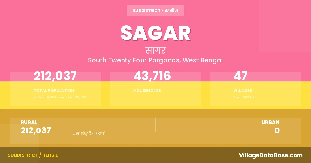
State → West Bengal
Sagar is a town and Subdivision in the South Twenty Four Parganas district of the West Bengal. In India, a Subdivision is a subdivision of a district responsible for the administration and revenue collection of a specific area within the district. Subdivisions play a crucial role in the local governance structure, contributing significantly to the development and administration of their communities.
According to the 2011 census The total area of Sagar Subdivision is 392 km², with a population of 212037 people. The population density is 541 inhabitants per square kilometre, and there are approximately 43716 houses in the sub district.
Sagar Subdivision comprises about 47 villages. Below is a list of these villages along with information about their respective gram panchayats and the nearest town:
| # | Village Name | Gram Panchayat | Nearest Town |
|---|---|---|---|
| 1 | Bamankhali | Muriganga Ii | Diamond Harbour (40 km) |
| 2 | Bankimnagar | Dhaspara Sumatinagar Ii | Diamond Harbour (69 km) |
| 3 | Bedford Island | Sagar | |
| 4 | Beguakhali | Gangasagar | Kakdwip (40 km) |
| 5 | Bisalakshmipur | Dhablat | Sagar |
| 6 | Bishnupur | Gangasagar | Kakdwip (42 km) |
| 7 | Chandipur | Gangasagar | Kakdwip (47 km) |
| 8 | Chemagari | Dhablat | Diamond Harbour (68 km) |
| 9 | Companir Char | Muriganga Ii | Diamond Harbour (45 km) |
| 10 | Debimathurapur | Dhaspara Sumatinagar I | Diamond Harbour (59 km) |
| 11 | Dhablat | Dhablat | Diamond Harbour (40 km) |
| 12 | Dhaspara | Dhaspara Sumatinagar I | Diamond Harbour (52 km) |
| 13 | Gangasagar | Gangasagar | Kakdwip (38 km) |
| 14 | Ghoramara | Ghoramara | Diamond Harbour (53 km) |
| 15 | Gobindapur | Dhaspara Sumatinagar I | Diamond Harbour (58 km) |
| 16 | Haradhanpur | Dhaspara Sumatinagar Ii | Diamond Harbour (65 km) |
| 17 | Harinbari | Ramkarchar | Diamond Harbour (64 km) |
| 18 | Kachubaria | Muriganga I | Diamond Harbour (53 km) |
| 19 | Kamalpur | Rudranagar | Diamond Harbour (65 km) |
| 20 | Kastala | Muriganga I | Diamond Harbour |
| 21 | Kaylapara | Dhaspara Sumatinagar I | Diamond Harbour (62 km) |
| 22 | Khan Saheber Abad | Ramkarchar | Diamond Harbour (68 km) |
| 23 | Khas Ramkarerchhar | Ramkarchar | Diamond Harbour (66 km) |
| 24 | Khasimara | Sagar | |
| 25 | Kirtankhali | Rudranagar | Diamond Harbour (80 km) |
| 26 | Krishnanagar | Ramkarchar | Diamond Harbour (60 km) |
| 27 | Lohachara | Sagar | |
| 28 | Mahendraganj | Dhaspara Sumatinagar I | Diamond Harbour (55 km) |
| 29 | Mahishamari | Gangasagar | Kakdwip (45 km) |
| 30 | Manasadwip 2nd Portion | Rudranagar | Diamond Harbour (65 km) |
| 31 | Mandirtala | Muriganga Ii | Diamond Harbour (56 km) |
| 32 | Mrityunjoynagar | Dhaspara Sumatinagar Ii | Diamond Harbour (65 km) |
| 33 | Muri Ganga | Muriganga I | Diamond Harbour (61 km) |
| 34 | Nagendraganj | Dhaspara Sumatinagar I | Diamond Harbour (57 km) |
| 35 | Naraharipur | Ramkarchar | Diamond Harbour (64 km) |
| 36 | Narayani Abad | Gangasagar | Kakdwip (40 km) |
| 37 | Natendrapur | Gangasagar | Kakdwip (40 km) |
| 38 | Phuldubi | Muriganga Ii | Diamond Harbour (56 km) |
| 39 | Purrusottampur | Dhablat | Diamond Harbour (64 km) |
| 40 | Radha Krishnapur | Rudranagar | Diamond Harbour (78 km) |
| 41 | Ramkrishnapur | Muriganga I | D/harbour (70 km) |
| 42 | Rudranagar | Rudranagar | Diamond Harbour |
| 43 | Sagar | Gangasagar | Sagar |
| 44 | Sapkhali | Muriganga I | Diamond Harbour (52 km) |
| 45 | Sibpur | Dhablat | Sagar |
| 46 | Sikarpur | Muriganga I | D/harbour (70 km) |
| 47 | Sumatinagar | Dhaspara Sumatinagar Ii | Sagar |
The population is distributed between urban and rural areas as follows:
| Particulars | Rural | Urban | Total |
|---|---|---|---|
| Total Population | 212037 | 0 | 212037 |
| Male Population | 109468 | 0 | 109468 |
| Female Population | 102569 | 0 | 102569 | Population Density | 541 / km² | 541 / km² |
The distribution of households in the Sagar is:
| Rural Households | Urban Households | Total Households |
|---|---|---|
| 43716 | 0 | 43716 |
Q: What is Sagar?
A: Sagar is a town and in the South Twenty Four Parganas district of the West Bengal.
Q: What is the total area of Sagar Subdivision?
A: The total area of Sagar Subdivision is 392 km².
Q: What is the population of Sagar Subdivision according to the 2011 census?
A: According to the 2011 census, the population of Sagar Subdivision is 212037.
Q: What is the population density of Sagar Subdivision?
A: The population density of Sagar Subdivision is 541 inhabitants per square kilometre.
Q: How many houses are there in Sagar Subdivision?
A: There are approximately 43716 houses in Sagar Subdivision.
Q: How many villages are there in Sagar Subdivision?
A: There are about 47 villages in Sagar Subdivision.
Q: Which is the largest village by population in Sagar Subdivision?
A: The largest village by population in Sagar Subdivision is Gangasagar, with 10340 people.
Q: Which is the smallest village by population in Sagar Subdivision?
A: The smallest village by population in Sagar Subdivision is Bedford Island, with 0 people.
Q: Which is the largest village by area in Sagar Subdivision?
A: The largest village by area in Sagar Subdivision is Gangasagar, with 1226 km².
Q: Which is the smallest village by area in Sagar Subdivision?
A: The smallest village by area in Sagar Subdivision is Bedford Island, with 0 km².
Q: What is the population distribution between urban and rural areas in Sagar Subdivision?
A: The population distribution in Sagar Subdivision is entirely rural, with a total rural population of 212037.
Q: What is the male population of Sagar Subdivision?
A: The male population of Sagar Subdivision is 109468.
Q: What is the female population of Sagar Subdivision?
A: The female population of Sagar Subdivision is 102569.
Q: How is the household distribution in Sagar Subdivision?
A: The household distribution in Sagar Subdivision is entirely rural, with a total of 43716 households.
Q: How many villages in Sagar Subdivision have a population of less than 100?
A: There are 5 villages in Sagar Subdivision with a population of less than 100.
Q: How many villages in Sagar Subdivision have a population between 100 and 499?
A: There are 1 villages in Sagar Subdivision with a population between 100 and 499.
Q: How many villages in Sagar Subdivision have a population between 1000 and 1999?
A: There are 3 villages in Sagar Subdivision with a population between 1000 and 1999.
Q: How many villages in Sagar Subdivision have a population between 2000 and 2999?
A: There is 5 village in Sagar Subdivision with a population between 2000 and 2999.
Q: How many villages in Sagar Subdivision have a population between 3000 and 3999?
A: There is 6 village in Sagar Subdivision with a population between 3000 and 3999.
Q: How many villages in Sagar Subdivision have a population between 4000 and 4999?
A: There is 4 village in Sagar Subdivision with a population between 4000 and 4999.
Q: How many villages in Sagar Subdivision have a population of 5000 and above?
A: There is 23 village in Sagar Subdivision with a population of 5000 and above.
| Total Population | Villages in Sub District Of Sagar |
|---|---|
| Less than 100 | 5 |
| 100-499 | 1 |
| 1000-1999 | 3 |
| 2000-2999 | 5 |
| 3000-3999 | 6 |
| 4000-4999 | 4 |
| 5000 And Above | 23 |