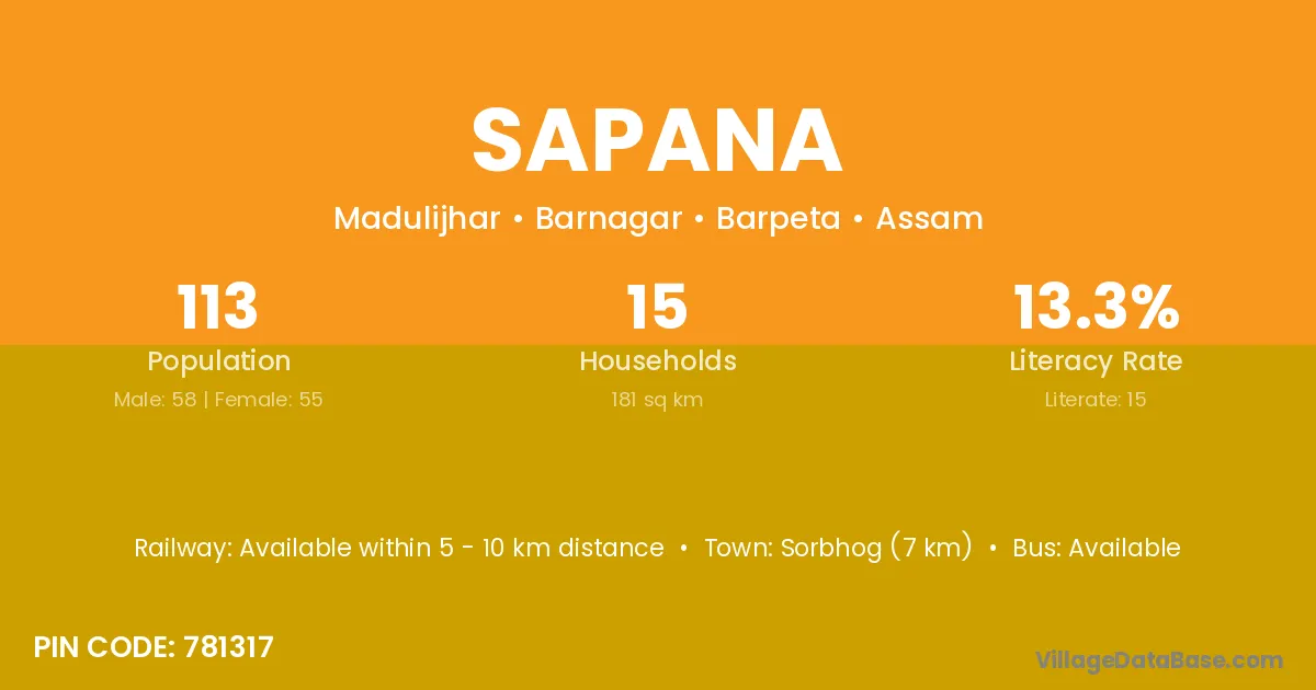
Sapana village is located in the Barnagar Subdivision of the Barpeta district in Assam .
Block / Subdivision → Barnagar
District → Barpeta
State → Assam
According to Census 2011 information, the village code of Sapana village is 781317.
Sapana village has a total population of 113 people, of which 58 are males and 55 are females.
The literacy rate of Sapana village is 13.27%. Male literacy stands at 15.52% and female literacy at 10.91%.
There are approximately 15 households in Sapana village.
Sorbhog (7 km) is the nearest town to Sapana village for major economic activities and is located approximately 7 km away.
The population of Sapana village is distributed between literate and illiterate residents as follows:
| Particulars | Male | Female | Total |
|---|---|---|---|
| Literate | 9 | 6 | 15 |
| Illiterate | 49 | 49 | 98 |
| Total | 58 | 55 | 113 |
Source: Census 2011
| Village | District |
|---|---|
| Barharid | Barpeta |
| Chal Chalia | Barpeta |
| Dakshin Bher Bheri | Barpeta |
| Dwarika | Barpeta |
| Dwarika | Baleshwar |
| Dwarika | Baleshwar |
| Dwarika | Deoria |
| Dwarika | Bankura |
| Ghilajari | Barpeta |
| Ghilajari | Barpeta |
| Jakua Para | Barpeta |
| Kurobaha | Baksa |
| Kurobaha | Barpeta |
| Kurobaha | Barpeta |
| Madulijar | Barpeta |
| Meda Gaon | Barpeta |
| Saru Harid | Barpeta |
| Tenga Gaon | Barpeta |
| Tenga Gaon | Lakhimpur |
| Tenga Gaon | Tinsukia |
No reviews yet. Be the first to review this village!
Available within 5 - 10 km distance
Available within 5 - 10 km distance
Available within 5 - 10 km distance