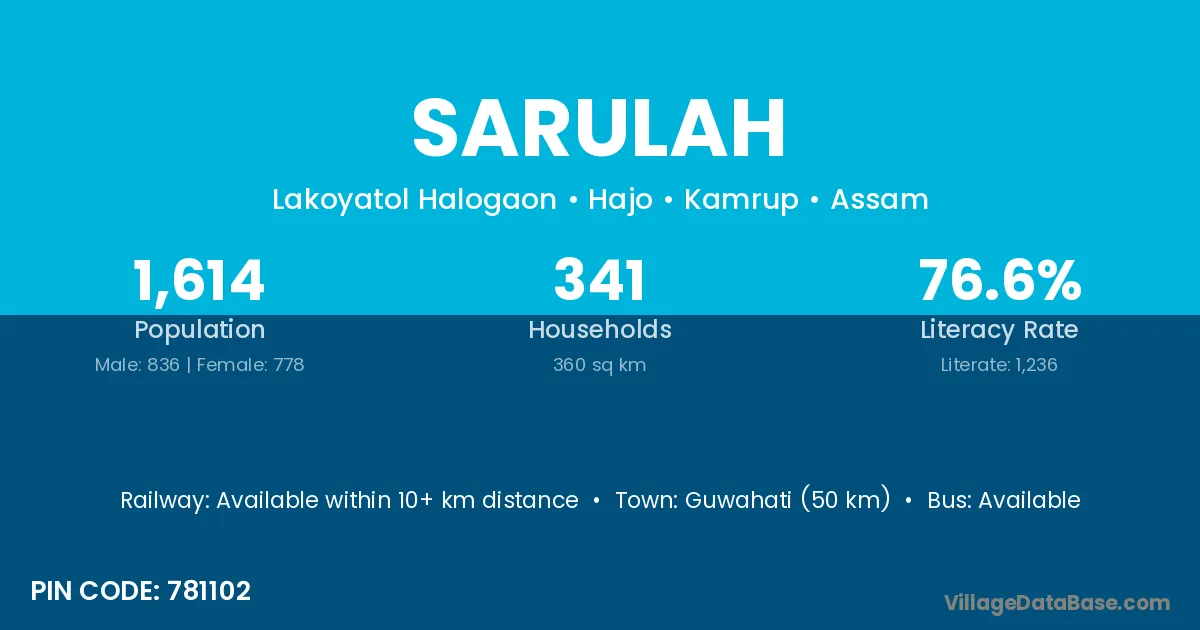
Sarulah village is located in the Hajo Subdivision of the Kamrup district in Assam .
Block / Subdivision → Hajo
District → Kamrup
State → Assam
According to Census 2011 information, the village code of Sarulah village is 781102.
Sarulah village has a total population of 1,614 people, of which 836 are males and 778 are females.
The literacy rate of Sarulah village is 76.58%. Male literacy stands at 82.30% and female literacy at 70.44%.
There are approximately 341 households in Sarulah village.
Guwahati (50 km) is the nearest town to Sarulah village for major economic activities and is located approximately 50 km away.
The population of Sarulah village is distributed between literate and illiterate residents as follows:
| Particulars | Male | Female | Total |
|---|---|---|---|
| Literate | 688 | 548 | 1,236 |
| Illiterate | 148 | 230 | 378 |
| Total | 836 | 778 | 1,614 |
Source: Census 2011
| Village | District |
|---|---|
| Bansar | Kamrup |
| Bansar | Bhadrak |
| Bansar | Jhansi |
| Bansar | Dehradun |
| Bardampur | Kamrup |
| Bathan | Kamrup |
| Bathan | Kamrup |
| Bathan | Umaria |
| Bathan | Solapur |
| Bathan | Sangrur |
| Bathan Pam | Kamrup |
| No 1 Halo Gaon | Kamrup |
| No 1 Shrihati | Kamrup |
| No 2 Halogaon | Kamrup |
| No 2 Sarudam Pur | Kamrup |
| No 2 Shrihati | Kamrup |
| No 3 Shrihati | Kamrup |
| Sanpara Parbat | Kamrup |
No reviews yet. Be the first to review this village!
Available within 10+ km distance
Available within village
Available within <5 km distance