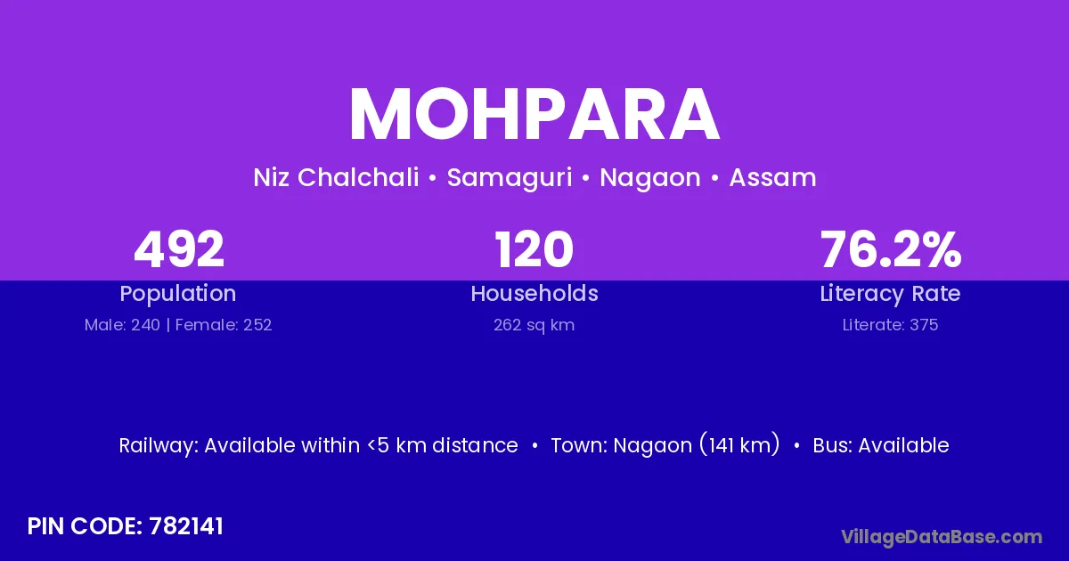
Mohpara village is located in the Samaguri Subdivision of the Nagaon district in Assam .
Block / Subdivision → Samaguri
District → Nagaon
State → Assam
According to Census 2011 information, the village code of Mohpara village is 782141.
Mohpara village has a total population of 492 people, of which 240 are males and 252 are females.
The literacy rate of Mohpara village is 76.22%. Male literacy stands at 78.75% and female literacy at 73.81%.
There are approximately 120 households in Mohpara village.
Nagaon (141 km) is the nearest town to Mohpara village for major economic activities and is located approximately 141 km away.
The population of Mohpara village is distributed between literate and illiterate residents as follows:
| Particulars | Male | Female | Total |
|---|---|---|---|
| Literate | 189 | 186 | 375 |
| Illiterate | 51 | 66 | 117 |
| Total | 240 | 252 | 492 |
Source: Census 2011
| Village | District |
|---|---|
| Ahomar Duba | Nagaon |
| Auniati Jalah | Nagaon |
| Baljuri Gaon | Nagaon |
| Bamuni Gaon | Kamrup |
| Bamuni Gaon | Kamrup |
| Bamuni Gaon | Kamrup |
| Bamuni Gaon | Kamrup |
| Bamuni Gaon | Nagaon |
| Bherbheri | Dhubri |
| Bherbheri | Kamrup |
| Bherbheri | Kamrup |
| Bherbheri | Nagaon |
| Bherbheri | Nagaon |
| Bherbheri | Koch Bihar |
| Chalchali Jalah | Nagaon |
| Dakhinpat Khat | Nagaon |
| Deuri Ati | Nagaon |
| Halowa Gaon | Nagaon |
| Halowa Gaon | Nagaon |
| Niz Chalchali | Nagaon |
| Saraguri | Nagaon |
No reviews yet. Be the first to review this village!
Available within <5 km distance
Available within <5 km distance
Available within <5 km distance