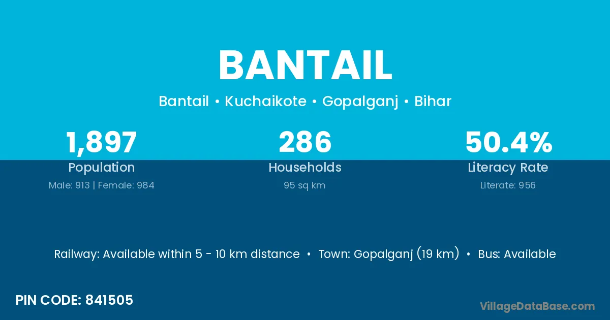
Bantail village is located in the Kuchaikote Subdivision of the Gopalganj district in Bihar .
Block / Subdivision → Kuchaikote
District → Gopalganj
State → Bihar
According to Census 2011 information, the village code of Bantail village is 841505.
Bantail village has a total population of 1,897 people, of which 913 are males and 984 are females.
The literacy rate of Bantail village is 50.40%. Male literacy stands at 59.69% and female literacy at 41.77%.
There are approximately 286 households in Bantail village.
Gopalganj (19 km) is the nearest town to Bantail village for major economic activities and is located approximately 19 km away.
The population of Bantail village is distributed between literate and illiterate residents as follows:
| Particulars | Male | Female | Total |
|---|---|---|---|
| Literate | 545 | 411 | 956 |
| Illiterate | 368 | 573 | 941 |
| Total | 913 | 984 | 1,897 |
Source: Census 2011
| Village | District |
|---|---|
| Bel Banwa | Gopalganj |
| Bindwalia | Gopalganj |
| Bindwalia | Deoria |
| Bindwalia | Ghazipur |
| Bindwalia | Kushinagar |
| Bindwalia | Mahrajganj |
| Chauranw | Gopalganj |
| Chauranw | Gopalganj |
| Doman Banjaria | Gopalganj |
| Kawalban Chak | Gopalganj |
| Malahi | Gopalganj |
| Malahi | Purba Champaran |
| Malahi | Saran |
| Malahi | Sitamarhi |
| Malahi | Sitamarhi |
| Malahi | Vaishali |
| Mateya Khas | Gopalganj |
| Mateya Nathu | Gopalganj |
| Mathia Khas | Gopalganj |
| Parsauni Panre | Gopalganj |
| Tola Guman Ray | Gopalganj |
No reviews yet. Be the first to review this village!
Available within 5 - 10 km distance
Available within 5 - 10 km distance
Available within village