District → Chamba
State → Himachal Pradesh
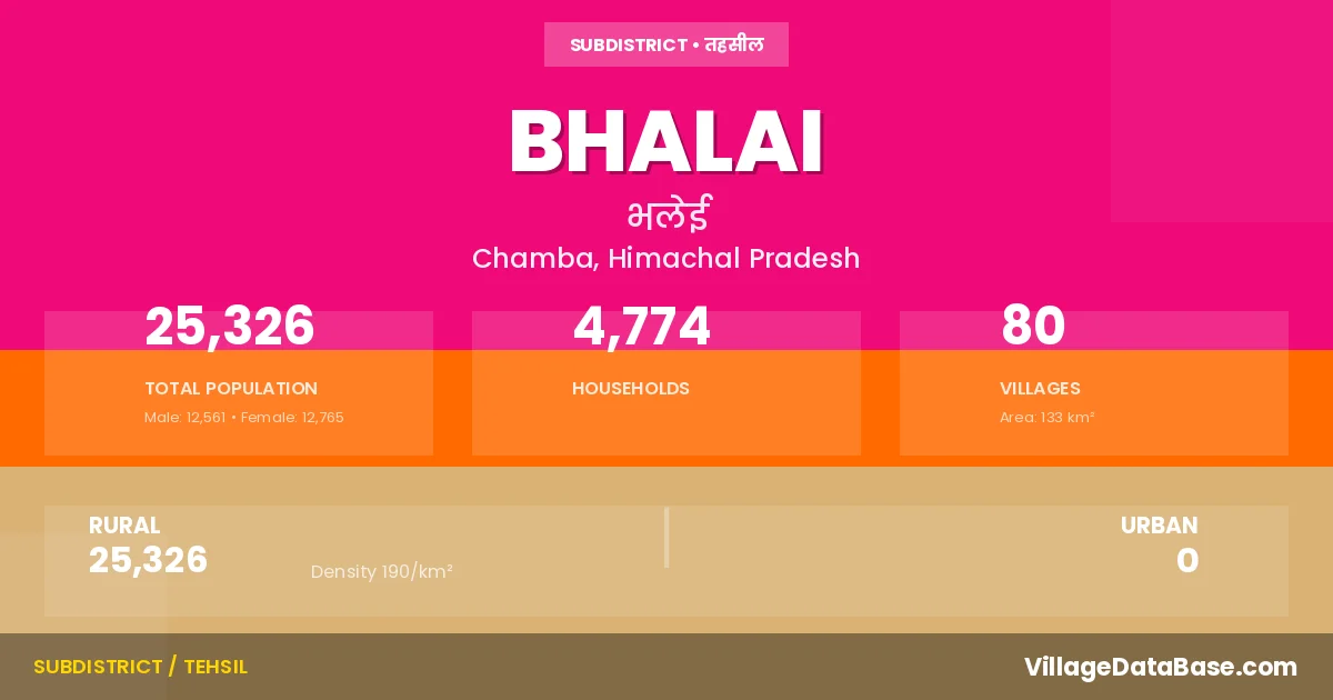
Bhalai is a town and Tehsil in the Chamba district of the Himachal Pradesh. In India, a Tehsil is a subdivision of a district responsible for the administration and revenue collection of a specific area within the district. Tehsils play a crucial role in the local governance structure, contributing significantly to the development and administration of their communities.
According to the 2011 census The total area of Bhalai Tehsil is 133 km², with a population of 25326 people. The population density is 190 inhabitants per square kilometre, and there are approximately 4774 houses in the sub district.
Bhalai Tehsil comprises about 80 villages. Below is a list of these villages along with information about their respective gram panchayats and the nearest town:
| # | Village Name | Gram Panchayat | Nearest Town |
|---|---|---|---|
| 1 | Andral | Seri | Chamba (35 km) |
| 2 | Baggi | Kanged | Dalhousie (25 km) |
| 3 | Banetu | Auhra | Dalhousie (25 km) |
| 4 | Basa | Kanged | Dalhousie (28 km) |
| 5 | Bhairoie | Badka | Chamba (62 km) |
| 6 | Bhajotra | Bhajotra | Chamba (65 km) |
| 7 | Bhalai | Bhalei | Chamba (45 km) |
| 8 | Bhalogi | Bhunad | Chamba (60 km) |
| 9 | Bhing | Gawalu | Chamba (32 km) |
| 10 | Bihali | Karwal | Chamba (57 km) |
| 11 | Bilauta | Gawalu | Chamba (40 km) |
| 12 | Brangal | Brangal | Chamba (50 km) |
| 13 | Bunhad | Bhunad | Chamba (50 km) |
| 14 | Chamoh | Simni | Chamba (50 km) |
| 15 | Chhananu | Simni | Chamba (40 km) |
| 16 | Chhatrel | Seri | Chamba (48 km) |
| 17 | Chhudra | Thakri Matti | Chamba (25 km) |
| 18 | D P F Galeni | Gawalu | Chamba (35 km) |
| 19 | D P F Nangali | Karwal | Chamba (62 km) |
| 20 | Dandi | Badka | Chamba (54 km) |
| 21 | Dei Kund | Bhunad | Chamba (60 km) |
| 22 | Dhar | Gawalu | Chamba (55 km) |
| 23 | Drabila | Simni | Chamba (40 km) |
| 24 | Drekri | Drekadi | Chamba (35 km) |
| 25 | Dror | Bhajotra | Chamba (71 km) |
| 26 | Dughar | Brangal | Chamba (52 km) |
| 27 | Gahua | Bhunad | Chamba (52 km) |
| 28 | Gri Jindu | Bhajotra | Chamba (65 km) |
| 29 | Gul | Naddal | Chamba (75 km) |
| 30 | Hadla | Brangal | Chamba (48 km) |
| 31 | Jandrera | Simni | Chamba (40 km) |
| 32 | Janna | Thakri Matti | Chamba (26 km) |
| 33 | Jhaura | Badka | Chamba (56 km) |
| 34 | Jutrahan | Naddal | Chamba (60 km) |
| 35 | Kamandi | Wangal | Chamba (35 km) |
| 36 | Kandi | Bhalei | Chamba (50 km) |
| 37 | Kanhar | Bhalei | Chamba (50 km) |
| 38 | Kantha | Wangal | Chamba (40 km) |
| 39 | Kaphlian | Auhra | Dalhousie (39 km) |
| 40 | Kareu | Kanged | Dalhousie (46 km) |
| 41 | Karwal | Karwal | Chamba (48 km) |
| 42 | Khajura | Simni | Chamba (50 km) |
| 43 | Khal | Naddal | Chamba (70 km) |
| 44 | Khaloh | Bhajotra | Chamba (68 km) |
| 45 | Khankur | Drekadi | Chamba (40 km) |
| 46 | Khilgran | Kanged | Dalhousie (22 km) |
| 47 | Kilor | Gawalu | Chamba (57 km) |
| 48 | Kiyani | Naddal | Chamba (50 km) |
| 49 | Kund | Manjhali | Chamba (35 km) |
| 50 | Kunda | Naddal | Chamba (70 km) |
| 51 | Lohad | Wangal | Dalhousie (39 km) |
| 52 | Malal | Manjhali | Chamba (30 km) |
| 53 | Malur | Gawalu | Chamba (43 km) |
| 54 | Mandoh | Auhra | Chamba (54 km) |
| 55 | Manjhal | Manjhali | Chamba (28 km) |
| 56 | Nadal | Naddal | Chamba (50 km) |
| 57 | Nagor | Naddal | Chamba (58 km) |
| 58 | Naled | Bhalei | Chamba (51 km) |
| 59 | Nangali | Karwal | Chamba (60 km) |
| 60 | Panjola | Bhunad | Chamba (60 km) |
| 61 | Parchhi | Kanged | Chamba (45 km) |
| 62 | R F Bhajotra | Bhajotra | Chamba |
| 63 | Sagoti | Bhajotra | Chamba (75 km) |
| 64 | Salori | Bhalei | Chamba (45 km) |
| 65 | Sama | Kanged | Dalhousie (45 km) |
| 66 | Sandwar | Karwal | Chamba (51 km) |
| 67 | Sangrut | Auhra | Dalhousie (40 km) |
| 68 | Sapan | Brangal | Chamba (50 km) |
| 69 | Saren | Auhra | Dalhousie (51 km) |
| 70 | Seri | Seri | Chamba (36 km) |
| 71 | Sikaryah | Auhra | Chamba (60 km) |
| 72 | Simini | Simni | Chamba (45 km) |
| 73 | Taleru | Brangal | Chamba (45 km) |
| 74 | Thal | Bhunad | Chamba (55 km) |
| 75 | Tiari | Thakri Matti | Chamba (27 km) |
| 76 | Tikar | Karwal | Chamba (55 km) |
| 77 | Toga | Karwal | Chamba (45 km) |
| 78 | Trer | Seri | Chamba (45 km) |
| 79 | Tunhi | Thakri Matti | Chamba (25 km) |
| 80 | Wangal | Wangal | Chamba (35 km) |
The population is distributed between urban and rural areas as follows:
| Particulars | Rural | Urban | Total |
|---|---|---|---|
| Total Population | 25326 | 0 | 25326 |
| Male Population | 12561 | 0 | 12561 |
| Female Population | 12765 | 0 | 12765 | Population Density | 190 / km² | 190 / km² |
The distribution of households in the Bhalai is:
| Rural Households | Urban Households | Total Households |
|---|---|---|
| 4774 | 0 | 4774 |
Q: What is Bhalai?
A: Bhalai is a town and in the Chamba district of the Himachal Pradesh.
Q: What is the total area of Bhalai Tehsil?
A: The total area of Bhalai Tehsil is 133 km².
Q: What is the population of Bhalai Tehsil according to the 2011 census?
A: According to the 2011 census, the population of Bhalai Tehsil is 25326.
Q: What is the population density of Bhalai Tehsil?
A: The population density of Bhalai Tehsil is 190 inhabitants per square kilometre.
Q: How many houses are there in Bhalai Tehsil?
A: There are approximately 4774 houses in Bhalai Tehsil.
Q: How many villages are there in Bhalai Tehsil?
A: There are about 80 villages in Bhalai Tehsil.
Q: Which is the largest village by population in Bhalai Tehsil?
A: The largest village by population in Bhalai Tehsil is Simini, with 758 people.
Q: Which is the smallest village by population in Bhalai Tehsil?
A: The smallest village by population in Bhalai Tehsil is D P F Nangali, with 0 people.
Q: Which is the largest village by area in Bhalai Tehsil?
A: The largest village by area in Bhalai Tehsil is Sagoti, with 547 km².
Q: Which is the smallest village by area in Bhalai Tehsil?
A: The smallest village by area in Bhalai Tehsil is D P F Nangali, with 9 km².
Q: What is the population distribution between urban and rural areas in Bhalai Tehsil?
A: The population distribution in Bhalai Tehsil is entirely rural, with a total rural population of 25326.
Q: What is the male population of Bhalai Tehsil?
A: The male population of Bhalai Tehsil is 12561.
Q: What is the female population of Bhalai Tehsil?
A: The female population of Bhalai Tehsil is 12765.
Q: How is the household distribution in Bhalai Tehsil?
A: The household distribution in Bhalai Tehsil is entirely rural, with a total of 4774 households.
Q: How many villages in Bhalai Tehsil have a population of less than 100?
A: There are 10 villages in Bhalai Tehsil with a population of less than 100.
Q: How many villages in Bhalai Tehsil have a population between 100 and 499?
A: There are 54 villages in Bhalai Tehsil with a population between 100 and 499.
Q: How many villages in Bhalai Tehsil have a population between 500 and 999?
A: There are 16 villages in Bhalai Tehsil with a population between 500 and 999.
| Total Population | Villages in Sub District Of Bhalai |
|---|---|
| Less than 100 | 10 |
| 100-499 | 54 |
| 500-999 | 16 |