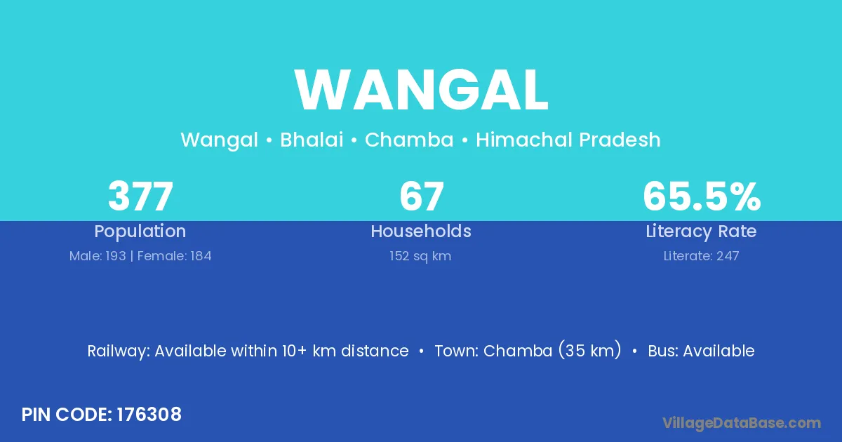
Wangal village is located in the Bhalai Tehsil of the Chamba district in Himachal Pradesh .
Block / Tehsil → Bhalai
District → Chamba
State → Himachal Pradesh
According to Census 2011 information, the village code of Wangal village is 176308.
Wangal village has a total population of 377 people, of which 193 are males and 184 are females.
The literacy rate of Wangal village is 65.52%. Male literacy stands at 76.68% and female literacy at 53.80%.
There are approximately 67 households in Wangal village.
Chamba (35 km) is the nearest town to Wangal village for major economic activities and is located approximately 35 km away.
The population of Wangal village is distributed between literate and illiterate residents as follows:
| Particulars | Male | Female | Total |
|---|---|---|---|
| Literate | 148 | 99 | 247 |
| Illiterate | 45 | 85 | 130 |
| Total | 193 | 184 | 377 |
Source: Census 2011
| Village | District |
|---|---|
| Chhananu | Chamba |
| Drabila | Chamba |
| Dughar | Chamba |
| Dughar | Una |
| Dughar | Thane |
| Hadla | Chamba |
| Hadla | Barddhaman |
| Hadla | Paschim Medinipur |
| Hadla | Puruliya |
| Hadla | Paschim Medinipur |
| Hadla | Puruliya |
| Kamandi | Chamba |
| Kanhar | Chamba |
| Kanhar | Mandla |
| Kanhar | Morena |
| Kantha | Gandhinagar |
| Kantha | Panch Mahals |
| Kantha | Chamba |
| Kantha | Baudh |
| Kantha | Unnao |
| Kantha | Rudraprayag |
| Kaphlian | Chamba |
| Lohad | Chamba |
| Sapan | Chamba |
| Taleru | Chamba |
No reviews yet. Be the first to review this village!
Available within 10+ km distance
Available within village
Available within village